Sources
Coordinates: 27°16′12″S31°38′06″E / 27.270°S 31.635°E
| | This Eswatini location article is a stub. You can help Wikipedia by expanding it. |
Salitje is a populated place in the south of Eswatini, by the border with South Africa, about 25 kilometres south of Hluthi.
Coordinates: 27°16′12″S31°38′06″E / 27.270°S 31.635°E
| | This Eswatini location article is a stub. You can help Wikipedia by expanding it. |

South Africa occupies the southern tip of Africa, its coastline stretching more than 2,850 kilometres from the desert border with Namibia on the Atlantic (western) coast southwards around the tip of Africa and then northeast to the border with Mozambique on the Indian Ocean. The low-lying coastal zone is narrow for much of that distance, soon giving way to a mountainous escarpment that separates the coast from the high inland plateau. In some places, notably the province of KwaZulu-Natal in the east, a greater distance separates the coast from the escarpment. Although much of the country is classified as semi-arid, it has considerable variation in climate as well as topography. The total land area is 1,220,813 km2 (471,359 sq mi). It has the 23rd largest Exclusive Economic Zone of 1,535,538 km2 (592,875 sq mi).
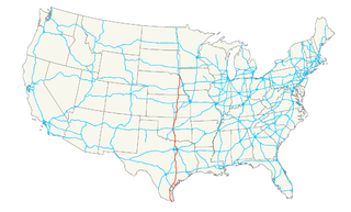
Interstate 70 (I-70) is a major east–west Interstate Highway in the United States that runs from I-15 near Cove Fort, Utah, to a Park and Ride lot just east of I-695 in Baltimore, Maryland. I-70 approximately traces the path of U.S. Route 40 east of the Rocky Mountains. West of the Rockies, the route of I-70 was derived from multiple sources. The Interstate runs through or near many major cities, including Denver, Topeka, Kansas City, St. Louis, Indianapolis, Columbus, Pittsburgh, and Baltimore. The sections of the interstate in Missouri and Kansas have laid claim to be the first interstate in the United States. The Federal Highway Administration has claimed the section of I-70 through Glenwood Canyon, Colorado, completed in 1992, to be the last piece of the Interstate Highway system, as originally planned, to open to traffic. The construction of I-70 in Colorado and Utah is considered an engineering marvel, as the route passes through the Eisenhower Tunnel, Glenwood Canyon, and the San Rafael Swell. The Eisenhower Tunnel is the highest point along the Interstate Highway system, with an elevation of 11,158 ft (3,401 m).

Sabine County is a county located on the central eastern border of the U.S. state of Texas. As of the 2010 census, its population was 10,834. Its county seat is Hemphill. The county was organized on December 14, 1837, and named for the Sabine River, which forms its eastern border.

South Taft is a census-designated place (CDP) in Kern County, California, United States. South Taft is located 0.5 miles (0.8 km) south of Taft, at an elevation of 1,017 feet (310 m). The population was 2,169 at the 2010 census, up from 1,898 at the time of the 2000 census.

Somerset is a village in St. Croix County, Wisconsin, along the Apple River. The population was 2,635 at the 2010 census. The village is located within the Town of Somerset.

The Ubangi River, also spelled Oubangui, is the largest right-bank tributary of the Congo River in the region of Central Africa. It begins at the confluence of the Mbomou and Uele Rivers and flows west, forming the border between Central African Republic (CAR) and Democratic Republic of the Congo. Subsequently, the Ubangi bends to the southwest and passes through Bangui, the capital of the CAR, after which it flows south – forming the border between Democratic Republic of the Congo and Republic of Congo. The Ubangi finally joins the Congo River at Liranga.
U.S. Route 77 is a major north–south United States Numbered Highway which extends for 1,305 miles (2,100 km) in the central United States. As of 2005, Its southern terminus is in Brownsville, Texas, at Veteran's International Bridge on the Mexican border, where it connects with both Mexican Federal Highway 101 and Mexican Federal Highway 180, and the highway's northern terminus is in Sioux City, Iowa, at an interchange with Interstate 29 (I-29).
Interstate 635 (I-635) is a 37-mile-long (60 km) partial loop around Dallas, Texas, in the United States between I-20 in Balch Springs and State Highway 121 (SH 121) at the north entrance of the Dallas-Fort Worth International Airport in Grapevine. It intersects I-35E at exits 27B–C, but does not connect with I-35W. A small part of I-635 and I-20 is collectively designated as the Lyndon B. Johnson Freeway; known locally as the LBJ Freeway, or simply LBJ. The roadway is named after Lyndon B. Johnson, the former U.S. Senator from Texas, 37th Vice President, and the 36th President of the United States. Where I-635 ends at I-20, I-20 continues the LBJ Freeway designation heading west.

The Palmiet Pumped Storage Scheme consists of two 200 megawatts (270,000 hp) turbine units located 2 kilometres (1.2 mi) upstream of the Kogelberg Dam on the Palmiet River near Cape Town, South Africa. The pumped-storage hydroelectricity plant is capable of responding to a surge in peak power demand in minutes. At night, excess power on the grid generated by conventional coal and nuclear plants is used to pump water to the Upper Reservoir overlooking Gordon's Bay.

A stack interchange is a particular, free-flowing type of design for interchanges, meaning grade-separated road junctions. It is referred to as a directional interchange in the American Association of State Highway and Transportation Officials Policy on Geometric Design of Highways and Streets.

Zululand is one of the 11 district municipalities ("districts") of KwaZulu-Natal province. The seat of Zululand is Ulundi. The majority of its 803,575 people speak IsiZulu. The district code is DC26. It is part of a larger historical area also known as Zululand.

Northwest Dallas is an area consisting of many communities and neighborhoods in Dallas, Texas, (USA).

Border Cave is a rock shelter on the western scarp of the Lebombo Mountains in KwaZulu-Natal near the border between South Africa and Swaziland. Border Cave has a remarkably continuous stratigraphic record of occupation spanning about 200 ka. Anatomically modern Homo sapiens skeletons together with stone tools and chipping debris were recovered. Dating by carbon-14, amino acid racemisation and electron spin resonance (ESR) places the oldest sedimentary ash at some 200 kiloannum.
The 2010 Currie Cup First Division was contested from 16 July through to 15 October 2010. The tournament is the second tier of South Africa's premier domestic rugby union competition, featuring teams representing either entire provinces or substantial regions within provinces.

Nkomazi Local Municipality, is a municipality of South Africa, located in the Ehlanzeni District Municipality, Mpumalanga. Malalane is the seat of the municipality.

The Kamerun Campaign took place in the German colony of Kamerun in the African theatre of the First World War when the British, French and Belgians invaded the German colony from August 1914 to March 1916. Most of the campaign took place in Kamerun but skirmishes also broke out in British Nigeria. By the Spring of 1916, following Allied victories, the majority of German troops and the civil administration fled to the neighbouring neutral colony of Spanish Guinea. The campaign ended in a defeat for Germany and the partition of its former colony between France and Britain.
The 2014 Currie Cup First Division was contested between 29 August and 17 October 2014. The tournament was the second tier of South Africa's premier domestic rugby union competition, featuring teams representing either entire provinces or substantial regions within provinces.
The 2016 Currie Cup qualification series was a South African rugby union competition organised by the South African Rugby Union which was played between 9 April and 23 July 2016. It featured all fourteen South African provincial unions plus the Welwitschias from Namibia and served as a qualifying competition for the 2016 Currie Cup, the 78th edition of South Africa's premier domestic rugby union competition. Nine teams from this competition advanced to the 2016 Currie Cup Premier Division, while the remaining six teams progressed to the 2016 Currie Cup First Division.
The iSimangaliso Marine Protected Area is a coastal and offshore marine protected area in KwaZulu-Natal from the South Africa-Mozambique border in the north to Cape St Lucia lighthouse in the south.

Heraclea at Latmus, or simply Heraclea or Herakleia (Ἡράκλεια), also transliterated as Heracleia, was a town on the confines between ancient Caria and Ionia, situated at the western foot of Mount Latmus on the Gulf of Latmus, which has since silted up. During the Hellenistic period it bore the name Pleistarcheia, probably after Pleistarchus. It was a small place in the south-east of Miletus, and south-west of Amyzon. In its neighbourhood a cave was shown with the tomb of Endymion. Ruins of this town still exist at the foot of mount Latmus on the borders of Lake Bafa, which is probably a portion of the ancient Sinus Latmicus, formed by the deposits of the river Maeander.