Related Research Articles

Shimla is the capital and the largest city of the northern Indian state of Himachal Pradesh. In 1864, Shimla was declared the summer capital of British India. After independence, the city became the capital of East Punjab and was later made the capital city of Himachal Pradesh. It is the principal commercial, cultural and educational centre of the state.
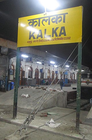
Kalka is a town in the Panchkula district of Haryana, India. It is near Panchkula city. The name of the town is derived from the Hindu goddess Kali. Kalka is situated in the foothills of the Himalayas and is a gateway to the neighbouring state of Himachal Pradesh; it is located on the National Highway 5 between Chandigarh and Shimla, and it is the terminus of the Kalka-Shimla Railway. To the south of Kalka is Pinjore, and the industrial village of Parwanoo is to the north on NH 22. Railways and Industrial development have led to a continuous urban belt from Pinjore to Parwanoo, but Kalka gained major economic benefits due to being the only highway destination until 2010 from Shimla. It is the tehsil of 253 nearby sub-villages. Nearby is Chandimandir Cantonment, where the Western Command of the Indian army is based. In 2013, the municipal committee of Kalka was dissolved and the administration was reassigned to Panchkula Municipal Corporation.

Harishchandra Fort is a hill fort in the Ahilyanagar(Ahmednagar) district of India. Its history is linked with that of Malshej Ghat, Kothale village and it has played a role in guarding and controlling the surrounding region.

Roha is a town and taluka in the Raigad district of the Maharashtra state of India. It is located 120 km southeast of Mumbai. It is the starting point of Konkan railways and end point of central railways (Mumbai). Many chemical industries have opened up their manufacturing bases in Roha. Roha is located between the banks of the Kundalika River and the hills of Kalasgiri. It has a population of over 20,849. Roha is connected to Mumbai by Panvel-Roha railway line. Roha is also the northern end of the Konkan Railway. Roha is off of the Mumbai Goa Highway, via the Kolad road.

Nahan is a town in Himachal Pradesh in India and is the headquarters of the Sirmaur District. It was the capital of the former Sirmur princely state. Nahan is also known as the "town of ponds".
Junnar is a city in the Pune district of the Indian state of Maharashtra. The city has history dating back to the first millennium. The nearby fort of Shivneri was the birthplace of Maratha king Shivaji, the founder of the Maratha Empire. Junnar was declared the first tourism taluka in Pune district by the government of Maharashtra on 9 January 2018.
Maihar is a city in the Maihar district of the Indian state of Madhya Pradesh. It's Administrative Headquarter of Maihar District. Maihar is known for the Maa Sharda Mandir situated in the city.
Kendrapara is a Town and a municipality in the Kendrapara district of the Indian state of Odisha. It is the headquarters of Kendrapara district.
Darwha is a town and a municipal council in Yavatmal district in the state of Maharashtra, India.
Rajgarh is a town and a nagar panchayat in Sirmaur district in the Indian state of Himachal Pradesh. It was a Princely State ruled by Raja of Raghuvanshi lineage.
Churdhar Sanctuary is located in the Sirmaur district of the Indian state of Himachal Pradesh. The total covered area of this sanctuary is 56.16 square kilometers, as notified on November 15, 1985. The fauna includes Himalayan black bear, Barking deer, Musk deer, Langur and Leopards. The work of administration at Churdhar is taken care by Chureshwar Sewa Samiti.

Sarahan is a small town in Himachal Pradesh of India. It is the site of the Bhimakali Temple, originally known as Bhimadevi Temple, dedicated to the mother goddess Bhimakali, presiding deity of the rulers of the former Bushahr State. The temple is situated about 170 kilometres from Shimla and is one of 51 Shakti Peethas. The town is known as the "gateway of Kinnaur" it being near the old Indo-Tibetan Road. Seven kilometers below Sarahan is the river Satluj. Sarahan is identified with the Shonitpur mentioned in Puranas. Sarahan Bushahr has been the summer capital of Bushahr kingdom, with Rampur Bushahr considered the winter capital. The former Chief Minister of Himachal Pradesh Shree Virbhadra Singh is a member of royal family and is popularly known as "Raja Sahab" at Sarahann. He has been member of the Assembly/Parliament since 1962 and has held the post of Chief Minister six times. His wife Rani Pratibha Devi is also a member of Assembly.
Haripurdhar is a small town in Sirmour, Himachal Pradesh, India. The town is situated on a high ridge overlooking a deep valley at an altitude of 2500 metres above sea level. It was earlier known as 'Dungbhangayani' and was the summer capital of Sirmour. In the months of May and June temperatures reach 0 to 5°C. In winters there is a view of snowfall. The town has three or four hotels and a guest house. A temple is situated on the border of Shimla and Sirmour. There are around 30 rooms with basic facilities in the temple premises. Maa Bhangayani Temple. There are many old temples of many deities in the adjoining villages.

Mahasu Devta Temple, is located on the Tyuni-Mori road at Hanol, Dehradun district, Uttarakhand, India and was built in the 9th century. The temple is dedicated to Mahasu Devta. The temple was constructed in the Kath-Kuni or Koti-Banal style of architecture and is included in the Archaeological Survey of India's list of the ancient temple in the Dehradun circle, Uttarakhand.
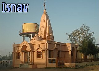
Isnav is a little village from one of the 22 Gam Patidar Samaj, situated at coordinates: 22°31'59"N | 72°45'51"E just nearby small town called Sojitra. Isnav is surrounded by natural countryside. The village has an entrance from the State Highway 83 in Gujarat. From the Gateway, off the highway just after 0.80 km drive is the village Isnav.
Kohoj is a medieval military fortification located near Palghar in Palghar district in Maharashtra, India.

Kasor is a village in Sojitra Taluka and Anand District, in Gujarat, India. The village has an entrance from the State Highway 83 in Gujarat. Entrance Gate of Kasor came off the highway just after 2.5 km drive. The 400 K.V.SS Power Station is considered as being in this village.

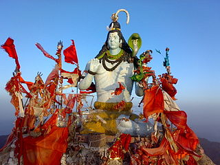
Hatu Peak is located in the Shimla district of Himachal Pradesh in India. It is one of the highest peaks in the region, standing at an elevation of 3400 meters (11,152ft) above sea level. The peak is surrounded by a dense forest of conifers, oaks, and maples.

Rohida fort / Vichitragad Fort is a fort located 10 km from Bhor, Pune district, of Maharashtra. This fort is an important fort in Pune district. The fort restoration is done by the Shree Shivdurga Samvardhan committee with the help of forest dept. and local villagers.

Kenjalgad Fort in Wai, Maharashtra is a fort eleven miles (18 km) north-west of Wai. It is located on the Mandhardev spur of the Mahadev hill range. The fort is visible from quite a long distance as a stone scarp 30–40 feet high rising as a cap on the irregular hill. The fort is rhomboid in shape with 388m long axis and 175m short axis.