The history of the Falkland Islands goes back at least five hundred years, with active exploration and colonisation only taking place in the 18th century. Nonetheless, the Falkland Islands have been a matter of controversy, as they have been claimed by the French, British, Spaniards and Argentines at various points.

Stanley is the capital city of the Falkland Islands. It is located on the island of East Falkland, on a north-facing slope in one of the wettest parts of the islands. At the 2016 census, the city had a population of 2,460. The entire population of the Falkland Islands was 3,398 on Census Day on 9 October 2016.

Weddell Island is one of the Falkland Islands in the South Atlantic, lying off the southwest extremity of West Falkland. It is situated 1,545 km (960 mi) west-northwest of South Georgia Island, 1,165 km (724 mi) north of Livingston Island, 606 km (377 mi) northeast of Cape Horn, 358 km (222 mi) northeast of Isla de los Estados, and 510 km (320 mi) east of the Atlantic entrance to Magellan Strait.

Speedwell Island is one of the Falkland Islands, lying in the Falkland Sound, southwest of Lafonia, East Falkland.

Carcass Island is the largest of the West Point Island Group of the Falkland Islands.

The Jason Islands are an archipelago in the Falkland Islands, lying to the far north-west of West Falkland. Three of the islands, Steeple Jason, Grand Jason and Clarke's Islet, are private nature reserves owned by the Wildlife Conservation Society of New York City. Other islands in the group are National Nature Reserves owned by the Falkland Islands Government.

Pebble Island is one of the Falkland Islands, situated north of West Falkland. It is possibly named after the peculiarly spherical pebbles found at its western tip.

San Carlos is a settlement in northwestern East Falkland, lying south of Port San Carlos on San Carlos Water. It is sometimes nicknamed "JB" after a former owner, Jack Bonner. The settlement consists of a number of properties including a dwelling with a small cafe which also provides craft facilities. As noted in the history section, there is a small museum that pays homage to the Falklands Conflict as well as local nature and culture.

The Camp is the term used in the Falkland Islands to refer to any part of the islands outside the islands' only significant town, Stanley, and often the large RAF base at Mount Pleasant. It is derived from the Spanish word campo, for "countryside".
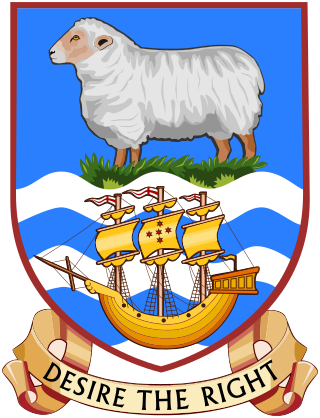
The coat of arms of the Falkland Islands is the heraldic device consisting of a shield charged with a ram on tussock grass in a blue field at the top and a sailing ship on white and blue wavy lines underneath. Adopted in 1948, it has been the coat of arms of the Falkland Islands since 29 September of that year, except for the two-month occupation of the territory during the Falklands War in 1982. The escutcheon is featured on the flag of the territory. The ram represents the territory's past primary industry of sheep farming, while the ship symbolises the Desire which reportedly first sighted the islands at the end of the 16th century. The grass indicates the vegetation of the Falklands.
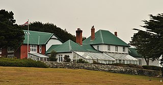
Government House in Stanley has been the home of the Falkland Islands' Governors since the mid-19th century. The official residence was built in 1845.

Port Egmont was the first British settlement in the Falkland Islands, on Saunders Island off West Falkland, and is named after the Earl of Egmont.

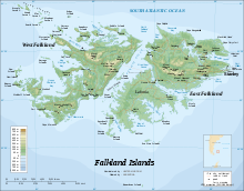
The Falkland Islands is an archipelago in the South Atlantic Ocean on the Patagonian Shelf. The principal islands are about 300 mi (480 km) east of South America's southern Patagonian coast and about 752 mi (1,210 km) from Cape Dubouzet at the northern tip of the Antarctic Peninsula, at a latitude of about 52°S. The archipelago, with an area of 4,700 sq mi (12,000 km2), comprises East Falkland, West Falkland, and 776 smaller islands. As a British overseas territory, the Falklands have internal self-governance, but the United Kingdom takes responsibility for their defence and foreign affairs. The capital and largest settlement is Stanley on East Falkland.
Port Patterson is a settlement on Carcass Island in the western Falkland Islands. It takes its name from the bay it is on, on the south west coast of the island. It was founded in the late 19th century.
The Falkland Islands have a complex history stretching over five hundred years. Active exploration and colonisation began in the 18th century but a self-supporting colony was not established till the latter part of the 19th century. Nonetheless, the islands have been a matter of controversy, as due to their strategic position in the 18th century their sovereignty was claimed by the French, Spaniards, British and Argentines at various points.

Duplicate: List of Falkland Islands-related topics
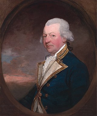
John MacBride was a British officer of the Royal Navy and a politician who saw service during the Seven Years' War, the American War of Independence and the French Revolutionary Wars, eventually rising to the rank of Admiral of the Blue.

The Capture of Port Egmont on 10 June 1770 was a Spanish expedition that seized the British fort of Port Egmont on the Falkland Islands, garrisoned since 1765. The incident nearly led to war between Great Britain and Spain, known as the Falklands Crisis.

Hope Harbour is an inlet at the north-west of West Falkland in the Falkland Islands of the South Atlantic Ocean. About 4 km long and 1.3 km wide, it is sheltered by the promontory of Grave Cove Camp in the south, a narrow ridge terminating in Hope Point to the north, Bramble Point Camp to the east, and West Point Island at its entrance to the west. Carcass Island lies 8 km north-east of Hope Point.