Machhermo

Last updated

Machermo river and Machermo Glacier Machermo, Kyajo Ri, Nepal.jpg
Machermo river and Machermo Glacier

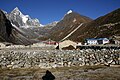
Machermo is a small village in the Khumbu region of eastern Nepal. It lies in the Dudh Kosi River valley just north of Dole and south of Gokyo at an altitude of 4470m, [1] just below the terminal moraine of the Ngozumpa glacier, the longest glacier in the Himalayas. [2]

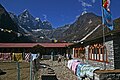
Machhermo is often a stopping point for trekkers on their way to Sagarmartha (Mount Everest) via the Gokyo Ri route. Its primary function is to support the tourism industry and as such consists of a number of guesthouses.


See also

Related Research Articles

<span class="mw-page-title-main">Khumbu</span> Region in northeastern Nepal

Khumbu is a region of northeastern Nepal on the Nepalese side of Mount Everest. It is part of the Solukhumbu District, which in turn is part of Koshi Pradesh. Khumbu is one of three subregions of the main Kirat Kulung and Sherpa settlement of the Himalaya, the other two being Solu and Pharak. It includes the town of Namche Bazaar as well as the villages of Thame, Khumjung, Pangboche, Pheriche and Kunde. The famous Buddhist monastery at Tengboche is also located in Khumbu.

<span class="mw-page-title-main">Khumjung</span> Former Village Development Committee in Nepal

Khumjung is a village in Khumbu Pasanglhamu rural municipality of Solukhumbu District in Province No. 1 of north-eastern Nepal. It is located in the Khumbu sub-region inside Sagarmatha National Park, a world heritage site. The village lies at an elevation of 3,790 metres above sea level, near Mount Khumbila.

<span class="mw-page-title-main">Dudh Koshi</span> River in Nepal

Dudh Koshi is a river in eastern Nepal. It is the highest river in terms of elevation. Dudh Koshi originates from the glacier lakes at the height of 5,100 meters above sea level and meets Sapta Koshi at the altitude of 1,245 meters.

<span class="mw-page-title-main">Khumbu Glacier</span> Highest glacier in the Himalayas

The Khumbu Glacier is located in the Khumbu region of northeastern Nepal between Mount Everest and the Lhotse-Nuptse ridge. With elevations of 4,900 m (16,100 ft) at its terminus to 7,600 m (24,900 ft) at its source, it is the world's highest glacier. The Khumbu Glacier is followed for the final part of the trail to one of the Everest Base Camps. The start of the glacier is in the Western Cwm near Everest. The glacier has a large icefall, the Khumbu Icefall, at the west end of the lower Western Cwm. This icefall is the first major obstacle—and among the more dangerous—on the standard south col route to the Everest summit. It is also the largest glacier in Nepal.

<span class="mw-page-title-main">Shackleton Glacier</span> Glacier in Antarctica

Shackleton Glacier is a major Antarctic glacier, over 60 nautical miles long and from 5 to 10 nautical miles wide, descending from the Antarctic Plateau from the vicinity of Roberts Massif and flowing north through the Queen Maud Mountains to enter the Ross Ice Shelf between Mount Speed and Waldron Spurs. Discovered by the United States Antarctic Service (USAS) (1939–41) and named by the Advisory Committee on Antarctic Names (US-ACAN) for Sir Ernest Shackleton, British Antarctic explorer.

<span class="mw-page-title-main">Taylor Glacier</span> Antarctic glacier

The Taylor Glacier is a glacier in Antarctica about 35 nautical miles long, flowing from the plateau of Victoria Land into the western end of Taylor Valley, north of the Kukri Hills. It flows to the south of the Asgard Range. The middle part of the glacier is bounded on the north by the Inland Forts and on the south by Beacon Valley.

<span class="mw-page-title-main">Ngozumpa glacier</span> Longest glacier in the Himalayas

The Ngozumpa glacier, below the sixth highest mountain in the world Cho Oyu in Nepal, at 36 kilometres (22 mi), is the longest glacier in the Himalayas. Ngozumpa Glacier is a large persistent body of ice. It flows slowly due to stresses induced by its weight.

<span class="mw-page-title-main">Everest base camps</span> Staging areas at Mount Everest

There are two base camps on Mount Everest, on opposite sides of the mountains: South Base Camp is in Nepal at an altitude of 5,364 metres (17,598 ft), while North Base Camp is in Tibet at 5,150 metres (16,900 ft).

<span class="mw-page-title-main">Dole, Nepal</span>

Dole is a small village in the Khumbu region of Nepal. It lies in the Dudh Kosi River valley just north of Khumjung and south of Machhermo at an altitude of 4038m.

<span class="mw-page-title-main">Gokyo Ri</span> Mountain in Nepal

Gokyo Peak is a 5,357 m (17,575 ft)-high peak in the Khumbu region of the Nepal Himalayas. It is located on the west side of the Ngozumpa glacier, which is the largest glacier in Nepal and reputed to be the largest in the whole Himalayas. Gokyo, at the base of Gokyo Ri, is a small village with several houses and lodges, and is one of the highest settlements in the world. From the summit of Gokyo Ri it is possible to see four 8,000-metre peaks: Mount Everest, Lhotse, Makalu and Cho Oyu. The Gokyo Lakes are in the area. Other mountains, such as Pumori and Nuptse are also visible from the top, along with five tranquil glacier lakes named together as gokyo lakes. The Gokyo-Ri summit is a 3-hour hike from the nearest village.

<span class="mw-page-title-main">Scott Glacier (Transantarctic Mountains)</span> Glacier in Antarctica

The Scott Glacier is a major glacier, 120 nautical miles long, that drains the East Antarctic Ice Sheet through the Queen Maud Mountains to the Ross Ice Shelf. The Scott Glacier is one of a series of major glaciers flowing across the Transantarctic Mountains, with the Amundsen Glacier to the west and the Leverett and Reedy glaciers to the east.

The Mariner Glacier is a major glacier over 60 nautical miles long, descending southeast from the plateau of Victoria Land, Antarctica, between Mountaineer Range and Malta Plateau, and terminating at Lady Newnes Bay, Ross Sea, where it forms the floating Mariner Glacier Tongue.

<span class="mw-page-title-main">Gokyo Lakes</span> Lakes in Nepal

Gokyo Lakes are oligotrophic lakes in Nepal's Sagarmatha National Park, located at an altitude of 4,700–5,000 m (15,400–16,400 ft) above sea level. Lakes and resorts were named after Gokyo Ri peak. These lakes are the world's highest freshwater lake system comprising six main lakes, of which Thonak Lake is the largest. In September 2007, Gokyo and its associated wetlands of 7,770 ha (30.0 sq mi) have been designated a Ramsar site.

Ambulapcha Glacier is a glacier of the Himalayas in the Solukhumbu District of Nepal. It adjoins Imja Glacier to its south and with Lhotse Shar Glacier forms three major glaciers. It forms the Ambulapcha Tsho glacial lake, located at 27°53′35″N86°54′47″E.

<span class="mw-page-title-main">Dughla</span> Geographical area in Nepal

Dughla is a small hamlet in Solukhumbu District in the Himalayas of Nepal, to the south of Khumbu Glacier. The settlement, consisting of several huts, is located at an elevation of 4,620 metres (15,160 ft), making it one of the highest settlements in the world, but likely not permanently inhabited all year around as it is essentially a collection of huts catering to hikers. Gokyo to the northwest is a little higher in elevation than Dughla. The village lies in an elevated position above and to the northeast of the lake, obscured from views of the lake by a rocky precipice. The village is best viewed on Google Earth at 27°55′27″N86°48′18″E. There also exists a glacial lake Tshola Tsho and Cho La Pass nearby.

<span class="mw-page-title-main">Gokyo</span> Village in Nepal

Gokyo is a small village in Solukhumbu District in the Himalayas of Nepal, at the foot of Gokyo Ri and located on the eastern shore of the third Gokyo Lake, Dudh Pokhari. To the southeast is the village of Chharchung. Gokyo is best viewed on Google Earth at 27°57′16″N86°41′43″E.

Chharchung is a small village in Solukhumbu District in the Himalayas of Nepal. It lies to the southeast of the Gokyo Lakes and Gokyo village and north of Khumjung. The village is located at an altitude of 4,502 metres (14,770 ft), making it one of the highest settlements in Nepal and in the world. The village is best viewed on Google Earth at 27°55′26″N86°43′24″E which reveals areas under cultivation, suggesting a permanent settlement. It is not a known village along the hiking route to Gokyo, lying across the valley.

<span class="mw-page-title-main">Cho La (Nepal)</span> Mountain pass in Nepal

Cho La is a summit pass located 5,420 metres (17,782 ft) above sea level in the Solukhumbu District in northeastern Nepal. It connects the village of Dzongla to the east and the village of Thagnak to the west.

<span class="mw-page-title-main">Monjo, Nepal</span> Village in Nepal

Monjo is a small village in the Khumbu region of Nepal. It lies in the Dudh Kosi river valley just north of Phakding and south of Jorsale, at an altitude of 2,835 m, just below the Sagarmatha National Park entrance gate and check-point, one of the UNESCO World Heritage Site since 1979. As per the census of 2011, Monjo village has a population of 114 people. All of them are followers of Buddhism and engaged in the tourism business.

<span class="mw-page-title-main">Jorsale</span> Village in the Khumbu region of Nepal

Jorsale is a small village in the Khumbu region of Nepal. It lies in the west side of the Dudh Kosi river, just north of Monjo and south of Namche Bazaar, at an altitude of 2,740 m,

References

  1. Archived 7 February 2011 at the Wayback Machine Nepal Map Publisher Ltd.& ISBN   978-9937-8062-1-3;
  2. "Glacial research frozen". Nepali Times, 30 December 2005 – 5 January 2006. Archived from the original on 25 July 2011. Retrieved 29 May 2010.

27°50′N86°42′E / 27.833°N 86.700°E / 27.833; 86.700