Transportation in Malawi is poorly developed. The country of almost 14 million has 39 airports, 6 with paved runways and 33 with unpaved runways. It has 495 miles (797 km) of railways, all narrow-gauge and about 45 percent of its roads are paved. Though it is landlocked, Malawi also has 435 miles (700 km) of waterways on Lake Malawi and along the Shire River.
Tete is a province of Mozambique. It has an area of 98,417 km² and a population of 2,764,169.

Beira is the capital and largest city of Sofala Province, where the Pungwe River meets the Indian Ocean, in the central region of Mozambique. It is the fourth-largest city by population in Mozambique, after Maputo, Matola and Nampula. Beira had a population of 397,368 in 1997, which grew to 530,604 in 2019. A coastal city, it holds the regionally significant Port of Beira, which acts as a gateway for both the central interior portion of the country as well as the land-locked nations of Zimbabwe, Zambia and Malawi.

Matola is the largest suburb of the Mozambique capital, Maputo, adjacent to its westernmost side. It is the nation's most populated city. Matola is the capital of Maputo Province and has had its own elected municipal government since 1998. It has a port and also the biggest industrial area in Mozambique. The population of Matola was, according to the 2007 census, 671,556 inhabitants, having increased to a 2017 census population of 1,616,267.
Langfang, is a prefecture-level city of Hebei Province, which was known as Tianjin Prefecture until 1973. It was renamed Langfang Prefecture after Tianjin became a municipality and finally upgraded into a prefecture-level city in 1988. Langfang is located approximately midway between Beijing and Tianjin. At the 2010 census, the population of Langfang was 4,358,839, of whom 868,066 lived in the built-up area made of Guangyang and Anci districts; its total area is around 6,417.28 km2 (2,477.73 sq mi). Langfang borders Baoding to the southwest, Cangzhou to the south, Beijing to the north and Tianjin to the east. Sanhe City and Dachang Hui County are now conurbated with Beijing, so that they form part of the same built-up area. Langfang is the smallest prefecture-level city of Hebei Province by land area.
Kamarajar Port Limited, formerly Ennore Port, is located on the Coromandel Coast about 24 km north of Chennai Port, Chennai, it is the 12th major port of India, and the first port in India which is a public company. The Kamarajar Port Limited is the only corporatised major port and is registered as a company. The Centre holds a stake of about 68 per cent in the Kamarajar Port Limited and the remaining 32 per cent is held by the Chennai Port Trust. The port has been able to attract an investment of ₹ 26,000 million by private entrepreneurs on various terminals and harbour craft. Kamarajar Port Limited, designed as Asia's energy port, is the first corporatised port in India and has only 86 employees. Envisaged being a satellite port to decongest and improve the environmental quality at the bustling Chennai Port, Kamarajar Port Limited is evolving itself into a full-fledged port with the capacity to handle a wide range of products. With a permissible draught of 13.5 m, the port handled a total volume of 11.01 million tonnes in 2010–11, up by 2.86 per cent from the previous year.

Mtwara is the capital city of Mtwara Region in southeastern Tanzania. In the 1940s, it was planned and constructed as the export facility for the disastrous Tanganyika groundnut scheme, but was somewhat neglected when the scheme was abandoned in 1951. The city is spread out over a large area planned to accommodate up to 200,000 people. The present population is around 80,000. As part of the development associated with the failed Tanganyika groundnut scheme, Mtwara features a deep-water port that can accommodate ocean-going vessels, and a range of large municipal buildings, including a post office. Recent improvements in the port made it possible for big container ships to berth there.
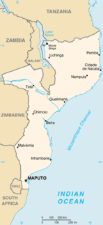
Moatize is the principal town and administrative center of Moatize District in western Mozambique's Tete Province. It is located on the eastern side of the Zambezi River at the confluence of the Moatize and Revuboe Rivers. After Tete, it is the second largest urban area, by population, in western Mozambique.

Cẩm Phả is a city of Quảng Ninh Province in the north-east region of Vietnam. It is an important coal exporting port of Vietnam. As of February 2012, the city had a population of 195,800. The city covers an area of 486 km². The city was promoted from Cẩm Phả District by February, 2012. Cẩm Phả was the site of one of the biggest coal mines in south of Asia which has been exploited for almost a century. The coal mine featured on a special commemorative Vietnam stamp in March 1959. Coal still forms the basis of Cẩm Phả's local economy, with other industries including quarrying, lime production, port, agriculture, forestry and fisheries.
Eswatini Railways (ESR), formerly known as Swaziland Railway or Swazi Rail, is the national railway corporation of Eswatini.

Kooragang is the northernmost and largest suburb of the city of Newcastle, in the Hunter Region of New South Wales, Australia. Dominated by Kooragang Island, the eastern part of the suburb is primarily industrial, while the western part of the suburb consists of nature reserves. Covering an area of 35.4 km2 (13.7 sq mi), at the 2016 census, there were no people living in the suburb.
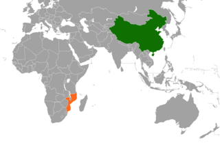
China–Mozambique relations date back to the 1960s, when China began to support the struggle of Mozambique's Marxist-oriented FRELIMO party against Portuguese colonialism. Diplomatic relations were formally established on 25 June 1975, soon after Mozambique gained independence from Portugal. In November 2006, Mozambique became the thirteenth African country to be added to China's official list of tourism destinations.

Matutuíne District is a district of Maputo Province in southern Mozambique. The principal town is Bela Vista. The district is located in the south of the province, and borders with the city of Maputo in the north, the province of KwaZulu-Natal of South Africa in the south, Swaziland in the west, and with Namaacha and Boane Districts in the northwest. In the east, the district is limited by the Indian Ocean. The area of the district is 5,387 square kilometres (2,080 sq mi). This is the southernmost district of Mozambique. It has a population of 37,165 as of 2007.
The mineral industry of Mozambique plays a significant role in the world’s production of aluminium, beryllium, and tantalum. In 2006, Mozambique's share of the world's tantalum mine output amounted to 6%; beryllium, 5%; and aluminium, 2%. Other domestically significant mineral processing operations included cement and natural gas.
Railway stations in Colombia.
Some of the more notable coal companies in Australia are the following:

The Mtwara Development Project is a major infrastructure development project involving southern Tanzania, northern Mozambique, eastern Malawi and Eastern Zambia. The goal of this project is to provide road, rail and waterway access from the surrounding region to the Port of Mtwara. The region and the corridor has been neglected by the respective governments for over 40 years and the recent discovery of oil, gas and various minerals has kick started the development of the project. A road and rail link is to be built from the port of Mtwara to Mbamba Bay on Lake Nyasa to link Malawi to the corridor and further road links into Mozambique will facilitate access to northern Mozambique.