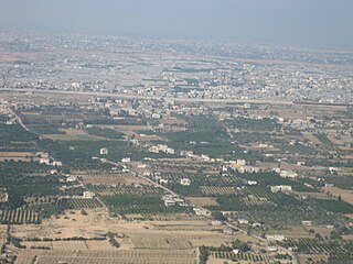
Rafah is a Palestinian city in the southern Gaza Strip. It is the capital of the Rafah Governorate of the State of Palestine, located 30 kilometers (19 mi) south-west of Gaza City. In 2017, Rafah had a population of 171,889. As a result of massive bombardment and ground assaults in Gaza City and Khan Yunis by Israel during the Israel–Hamas war, about 1.4 million Palestinians are believed to be sheltering in Rafah as of February 2024.

Demographic features of the population of the area commonly described as Palestinian territories includes information on ethnicity, education level, health of the populace, economic status, religious affiliations and other aspects of that population.

The North Gaza Governorate is one of the five Governorates of Palestine in the Gaza Strip which is administered by Palestine, aside from its border with Israel, airspace and maritime territory. According to the Palestinian Central Bureau of Statistics, the Governorate had a population of 270,245 with 40,262 households in mid-year 2007 encompassing three municipalities, two rural districts and one refugee camp.
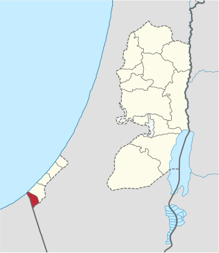
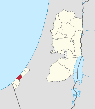
The Rafah Governorate is a Governorate of Palestine in the southernmost portion of the Gaza Strip. Its district capital or muhfaza is the city of Rafah located on the border with Egypt. According to the Palestinian Central Bureau of Statistics, the governorate had a population of 267,635 in mid-year 2022. It contains the closed down Yasser Arafat International Airport.

The Gaza Governorate, also alternatively known as Gaza City Governorate, is one of the 16 Governorates of Palestine, located in the north central Gaza Strip. Gaza is claimed by the State of Palestine, but the land is under the control of Hamas, while its border with Israel, airspace and maritime territory are controlled by the IDF. According to the Palestinian Central Bureau of Statistics, the district's population was 505,700 in 2006. All of its seats were won by Hamas members in the 2006 parliamentary elections. It is governed by Mohammed Qadoura.

The Khan Yunis Governorate is one of 16 Governorates of Palestine, located in the southern Gaza Strip. Its district capital is Khan Yunis. According to the Palestinian Central Bureau of Statistics, the governorate had a population of 426,056 in mid-2022. Its land area is 69.61% urban, 12.8% rural, and 17.57% comprising the Khan Yunis refugee camp.
The Deir al-Balah Governorate, also referred to as Central Gaza Governorate is one of 16 Governorates of Palestine in the central Gaza Strip which is administered by Palestine aside from its border with Israel, airspace, and maritime territory. Its total land area consists of 56 sq. kilometers. According to the Palestinian Central Bureau of Statistics, in mid-year 2022 it had a population of 310,820 inhabitants distributed between eight localities.
Al-Arroub is a Palestinian refugee camp located adjacent to the town of Shuyukh al-Arrub in the southern West Bank along the Hebron-Jerusalem road, in the Hebron Governorate of the State of Palestine. Al-Arroub is 15 kilometers south of Bethlehem, with a total land area of 240 dunums.
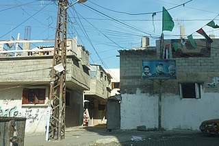
Al-Shati, also known as Shati or Beach camp, is a Palestinian refugee camp located in the northern Gaza Strip along the Mediterranean Sea coastline in the Gaza Governorate, and more specifically Gaza City.
Wadi as-Salqa is a Palestinian agricultural town in the Deir al-Balah Governorate, located south of Deir al-Balah. According to the Palestinian Central Bureau of Statistics (PCBS), the municipality had a population of 6,715 in 2017.
Al-Mughraqa is a Palestinian town in the Gaza Governorate of the Gaza Strip, located six kilometers southwest of Gaza City. According to the Palestinian Central Bureau of Statistics (PCBS), al-Mughraqa had a population of 11,458 in 2017. The town's alternate name, "Abu Middein" derives from the Bedouin Abu Middein tribe that inhabits the area, part of the larger al-Hanajreh tribal confederation.
Shokat as-Sufi is a Palestinian town in the southern Gaza Strip, south of Rafah and adjacent to the inoperable Yasser Arafat International Airport. It is one of the poorest localities in the Gaza Strip, and has underdeveloped infrastructure.
Juhor ad-Dik is a Palestinian farming village in the Gaza Governorate, south of Gaza City, in the central Gaza Strip. According to the Palestinian Central Bureau of Statistics (PCBS), the village had a population of 4,586 inhabitants in 2017. This area is controlled by Israel due to the Israel–Hamas war. In May, 2024, the Washington Post reported that the village had been destroyed in order to construct the Netzarim Corridor.
Az-Zawayda, also spelled Zawaida, is a Palestinian town in the Gaza Strip, in the Deir al-Balah Governorate of the State of Palestine. It is located about three kilometers northeast of the city of Deir al-Balah and just west of Maghazi refugee camp. According to the Palestinian Central Bureau of Statistics (PCBS) 2017 census, there were 23,841 residents.
Al-Musaddar is a Palestinian village in the central Gaza Strip, part of the Deir al-Balah Governorate east of Deir al-Balah, south of the Maghazi refugee camp and west of the border with Israel. In the 1997 census its population was 1,277. Al-Musaddar had a population of 2,587 in 2017 according to the Palestinian Central Bureau of Statistics (PCBS).
Qizan an-Najjar is a Palestinian village in the southern Gaza Strip, part of the Khan Yunis Governorate. It is located along the Salah al-Din Road between Khan Yunis and Rafah. In the 1997 census by the Palestinian Central Bureau of Statistics (PCBS) Qizan an-Najjar had a population of 2,733. Its population rose to 3,889 in the 2006 estimate by the PCBS.
Al-Bayuk is a Palestinian village in the Rafah Governorate located south of Rafah in the southern Gaza Strip. According to the Palestinian Central Bureau of Statistics (PCBS), it had a population of 5,648 in 2006.
Om al-Nasr or Al-Qaraya al-Badawiya is an area within the northern Gaza governorate in Palestine. The population of the village was about 4,737 according to Palestinian Central Bureau of Statistics (PCBS) in 2017. The village was established in 1997 on an area of 800 dunums.
Awda or al-Awda may refer to:
