Madron Well and Madron Well Chapel

Last updated

Madron Well and Madron Well Chapel
Madron Well - geograph.org.uk - 237874.jpg
Madron well
Southwest Cornwall UK location map.svg
Archaeological site icon (red).svg
Shown within Southwest Cornwall
Location Cornwall
Coordinates 50°08′23″N5°34′33″W / 50.13985°N 5.57587°W / 50.13985; -5.57587 Coordinates: 50°08′23″N5°34′33″W / 50.13985°N 5.57587°W / 50.13985; -5.57587
TypeChapel and well
History
Periods Medieval
Site notes
OwnershipBolitho Estate
Public accessYes

Madron Well and Madron Well Chapel is a scheduled Ancient Monument in the civil parish of Madron, Cornwall, UK.

Contents

Madron Well Chapel (grid reference SW446328 ) is the ruin of a 12th- or 14th-century chapel dedicated to St Madern and occupies the site of a much older Celtic structure. Madron Well (grid reference SW445327 ) is a spring 200 m to the west. Clouties, or offerings, can be seen on the path to the chapel, near the holy well.

Location

The chapel and well are 1 mile (1,600 m) to the north-west of the village of Madron and is within the civil parish of the same name. [1] The Bolitho estate owns the monument. [2]

History and description

The remains of Madron Well Chapel Remains of Madron Well Chapel - geograph.org.uk - 230766.jpg
The remains of Madron Well Chapel
The altar stone in the chapel The altar stone in Madron Chapel - geograph.org.uk - 1185878.jpg
The altar stone in the chapel

In 1846 the building's measurements were published in The Archaeological Journal and the roofless building's internal measurements were 20 feet (6.1 m) long by 10 feet (3.0 m) wide, and the walls are 2 feet (61 cm) thick and 8 or 9 feet (2.4 or 2.7 m) high. [3]

Measurements published in The Cornishman newspaper of 15 May 1879 gave the external length as 25 feet by 16 feet breadth (7.6 × 4.9 m) and the walls 2 feet (61 cm) thick. The granite altar stone is 5 ft 10 in (178 cm) long, 2 ft 7 in (79 cm) wide and stands 2 ft 10 in (86 cm) above the floor. There is a depression of 9 by 8 inches (23 by 20 centimetres) to contain the portable mensa for the celebration of mass. [4] The altar appears to date from the first half or middle of the 12th century as do the stone seats and chancel. There is no evidence for any part of the structure being older but the existing structure does suggest an early Christian foundation. [3] The building was partially destroyed by Major Ceely, during the English Civil War. [4] At the 1886 annual meeting of the Penzance Natural History and Antiquarian Society, concern was shown for the removal of stone from here, as well as Kenidjack Castle and Chûn Castle. [5]

A stream flows through the building and until the 18th century the well and stream were the only source of water for Madron and Penzance. The stream's course dictates the unusual placing of the entrance which is on the north wall instead of the normal, west of centre. [6]

The chapel was first scheduled on 30 November 1926; it is currently scheduled under the Ancient Monuments and Archaeological Areas Act 1979 and is considered to be of national importance. [7]

It is a classic site for the nationally scarce Cornish moneywort ( Sibthorpia europaea ), first reported here in 1824. [8] [9]

Well

Clouties tied to a tree near Madron Well Clouties near madron well.jpg
Clouties tied to a tree near Madron Well

The nearby Madron Well, which is now concealed in shrubs and undergrowth, is an example of a Cornish Celtic sacred site and is a ground level natural spring. [6] The well is said to have healing properties and a 17th-century written account tells how, before 1641, John Trelille, a poor cripple, was cured here when he bathed in the water, then slept on a grassy hillock. The hillock was remade every year and was called St Maderne's bed. [6] An old May Day tradition, which was still being observed in 1879, was for many young folks (mainly girls) to head from Penzance before sunrise, to perform a ceremony, to learn the number of years they have to wait before they get married. Two grass stems or straw, each about an inch long were fastened together with a pin and dropped into the water. Any rising bubbles denote the number of years before they get married. The ceremony was no longer held on May Day, but on a Sunday, because the girls work during the week. [10] A tradition at this site persists to this day whereby people attach pieces of rag (clouties) to the nearby bushes as a symbol of appeasement to the spirits within the well (see also Clootie well ) – according to a contemporary report in The Cornishman newspaper that tradition was no longer carried out in 1879. [10]

In 1882 there was a proposal to pipe water from the well to Madron Churchtown at a cost of £150, Mr T S Bolitho offered to contribute to the cost. [11]

Related Research Articles

<span class="mw-page-title-main">Chûn Castle</span> Iron Age hillfort in Cornwall, England

Chûn Castle is a large Iron Age hillfort (ringfort) near Penzance in Cornwall, England, United Kingdom. The fort was built about 2,500 years ago, and fell into disuse until the early centuries AD when it was possibly re-occupied to protect the nearby tin mines. It stands beside a prehistoric trackway that was formerly known as the Old St Ives Road and the Tinners’ Way. The name Chûn derives from Cornish: Chi an Woon. The area is now sometimes known as Chûn Downs. Nearby is Chûn Quoit.

<span class="mw-page-title-main">Penzance</span> Town in Cornwall, England

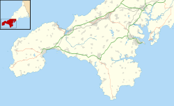
Penzance is a town, civil parish and port in the Penwith district of Cornwall, United Kingdom. It is the most westerly major town in Cornwall and is about 64 miles (103 km) west-southwest of Plymouth and 255 miles (410 km) west-southwest of London. Situated in the shelter of Mount's Bay, the town faces south-east onto the English Channel, is bordered to the west by the fishing port of Newlyn, to the north by the civil parish of Madron and to the east by the civil parish of Ludgvan. The civil parish includes the town of Newlyn and the villages of Mousehole, Paul, Gulval, and Heamoor. Granted various royal charters from 1512 onwards and incorporated on 9 May 1614, it has a population of 21,200.

<span class="mw-page-title-main">Towednack</span> Human settlement in England

Towednack is a churchtown and civil parish in Cornwall, England, United Kingdom. The parish is bounded by those of Zennor in the west, Gulval in the south, Ludgvan in the west and south, and St Ives and the Atlantic Ocean in the north and east. The church is about two miles (3 km) from St Ives and six miles (10 km) from Penzance.

<span class="mw-page-title-main">Madron</span> Human settlement in England

Madron is a civil parish and village in west Cornwall, Great Britain. Madron is named after Saint Madern's Church. Its annual Trafalgar Service commemorating the death of Vice Admiral Horatio Nelson was started on 27 October 1946, following a local tradition that his death was first announced on British soil in the Union Hotel, Penzance.

<span class="mw-page-title-main">St Levan</span> Human settlement in England

St Levan is a civil parish in Cornwall, England, United Kingdom. The parish is rural with a number of hamlets of varying size with Porthcurno probably being the best known. Hewn out of the cliff at Minack Point and overlooking the sea to the Logan Rock is the open-air Minack Theatre, the inspiration of Rowena Cade in the early 1930s.

<span class="mw-page-title-main">Sancreed</span> Human settlement in England

Sancreed is a village and civil parish in Cornwall, England, approximately three miles (5 km) west of Penzance.

<span class="mw-page-title-main">Trengwainton Garden</span> Country House (private) and National Trust Garden in Penzance, England

Trengwainton is a garden situated in Madron, near Penzance, Cornwall, England, UK, which has been in the ownership of the National Trust since 1961. The garden is noted for its collection of exotic trees and shrubs and offers views over Mount's Bay and The Lizard. The house is not open to the public.

<span class="mw-page-title-main">Gulval</span> Village in Cornwall, England

Gulval is a village in Cornwall, England, United Kingdom. Although historically a parish in its own right, Gulval was incorporated into the parishes of Ludgvan, Madron and Penzance in 1934, and is now considered to be a suburb of Penzance. Gulval still maintains its status as an ecclesiastical parish and parts of the village church date back to the 12th-century. Together with Heamoor, Gulval still retains its status as an electoral ward. The ward population at the 2011 census was 4,185.

<span class="mw-page-title-main">Heamoor</span> Village in Cornwall, England

Heamoor is a village in Cornwall, England. Formerly a secondary settlement of the village of Madron, Heamoor is situated approximately one-and-a half kilometres northwest of Penzance town centre.

<span class="mw-page-title-main">Chyandour</span>

Chyandour is a small settlement within the town of Penzance in west Cornwall, United Kingdom. It is on the north-east edge of the town straddling the A30 trunk road. The Chyandour Brook rises near Carfury and flows into Mount's Bay at Chyandour. Before 1934 Chyandour was in the parish of Madron and was the site of a large tin smelting works.

<span class="mw-page-title-main">Wherrytown</span>

Wherrytown is a small settlement in west Cornwall, United Kingdom, on the east side of the Laregan River, between Newlyn and Penzance. It was formerly in the civil parish of Madron and was incorporated into the Borough of Penzance in 1934 when local government was reorganised.

<span class="mw-page-title-main">Castle Horneck</span> Historic site

Castle Horneck is a Grade II* listed building, and refurbished Georgian mansion to the west of the Cornish town of Penzance. It is currently owned by the Youth Hostels Association (YHA) and has been used as a youth hostel since 1950.

<span class="mw-page-title-main">Tregavarah</span> Hamlet in west Cornwall, England

Tregavarah is a small hamlet in the parish of Madron in west Cornwall, England, U K. It is approximately 2 miles west of Penzance. Tregavarah Downs is nearby.

<span class="mw-page-title-main">Gurnard's Head</span> Headland on the north coast of Cornwall, England

Gurnard's Head is a prominent headland on the north coast of the Penwith peninsula in Cornwall, England, UK. The name is supposed to reflect that the rocky peninsula resembles the head of the gurnard fish.

<span class="mw-page-title-main">Penlee House</span>

Penlee House is a museum and art gallery located in the town of Penzance in Cornwall, and is home to a great many paintings by members of the Newlyn School, including many by Stanhope Forbes, Norman Garstin, Walter Langley and Lamorna Birch. Penlee House is currently operated by Penzance Town Council in association with Cornwall Council. Its most well-known painting is The Rain It Raineth Every Day by Norman Garstin who lived for many years in Wellington Terrace, on the edge of the park.

<span class="mw-page-title-main">A3071 road</span> Road in Cornwall

The A3071 is a minor 'A' road in the English county of Cornwall, which links St Just to Penzance and the A30. It is 6.2 miles long.

Sir Edward Hoblyn Warren Bolitho was a Cornish landowner and politician. He was Chairman of Cornwall County Council from 1941 to 1952 and Lord Lieutenant of Cornwall from 1936 to 1962, for some years serving in both roles simultaneously.

<span class="mw-page-title-main">Lanyon (Madron)</span> Human settlement in England

Lanyon is a hamlet in the parish of Madron in Cornwall, England, UK. It is situated on a north facing slope on the Madron to Morvah road. The nearest town is Penzance 4 miles (6.4 km) to the south.

<span class="mw-page-title-main">St Mary's Church, Penzance</span> Church in Cornwall, England

St Mary's Church, Penzance is a Grade II* listed parish church in the Church of England in Penzance, Cornwall.

<span class="mw-page-title-main">Egyptian House, Penzance</span>

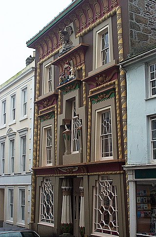
The Egyptian House is a grade I listed building in the Cornish town of Penzance. It is built in the style of Egyptian Revival architecture and has been in the ownership of the Landmark Trust since the 1970s. The current building dates from 1835 to 1836.

References

  1. OS Explorer Map 102. Land's End. Southampton: Ordnance Survey. 2005. ISBN   0 319 23703 6.
  2. Preston-Jones, Ann. "Scheduled Monument Management Project, 1999-2000". Cornwall Archaeology. 39: 210.
  3. 1 2 Historic England. "Madron Well and Madron Well Chapel (424435)". Research records (formerly PastScape). Retrieved 10 January 2016.
  4. 1 2 "Madron Well". The Cornishman. No. 44. 15 May 1879. p. 5.
  5. Bolitho, W (18 November 1886). "The Voluntary Institutions of Penzance: or Self-help Rather Than State Direction". The Cornishman. No. 436. p. 4.
  6. 1 2 3 Charles Thomas (1974). Christian Sites in West Penwith Excursion Guide. Redruth: Institute of Cornish Studies. pp. 3–7. ISBN   0 903686 04 X.
  7. Historic England. "Medieval chapel known as Madron Well Chapel associated with Madron holy well (1006728)". National Heritage List for England . Retrieved 10 January 2016.
  8. Paris, J A (1824). Guide to Mount's Bay and Land's End (Second ed.). ISBN   978-1507837238.
  9. French, Colin N; Murphy, Rosaline J; Atkinson, Mary G C (1999). Flora of Cornwall. Camborne: Wheal Seton Press. ISBN   978-0953461301.
  10. 1 2 "Madron Well. May Day There". The Cornishman. No. 43. 8 May 1879. p. 4.
  11. "Churchtown-Stream". The Cornishman. No. 216. 31 August 1882. p. 5.