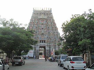
Kumbakonam, or Kudanthai, is a city municipal corporation in the Thanjavur district in the Indian state of Tamil Nadu. It is located 40 km (25 mi) from Thanjavur and 282 km (175 mi) from Chennai and is the headquarters of the Kumbakonam taluk of Thanjavur district. It is the second largest city in the district after Thanjavur. The city is bounded by two rivers, the Kaveri River to the north and Arasalar River to the south. Kumbakonam is known as a "Temple town" due to the prevalence of a number of temples here and is noted for its Mahamaham festival, which happens once in 12 years, attracting people from all over the country.

The Carnatic region is the peninsular South Indian region between the Eastern Ghats and the Bay of Bengal, in the erstwhile Madras Presidency and in the modern Indian states of Tamil Nadu and southern coastal Andhra Pradesh. During the British era, demarcation was different and the region included current day Karnataka and the whole region south of the Deccan.

The Pandyan dynasty, also referred to as the Pandyas of Madurai, was an ancient Tamil dynasty of South India, and among the four great kingdoms of Tamilakam, the other three being the Pallavas, the Cholas and the Cheras. Existing since at least the 4th to 3rd centuries BCE, the dynasty passed through two periods of imperial dominance, the 6th to 10th centuries CE, and under the 'Later Pandyas'. Under Jatavarman Sundara Pandyan I and Maravarman Kulasekara Pandyan I, the Pandyas ruled extensive territories including regions of present-day South India and northern Sri Lanka through vassal states subject to Madurai.

Karur is a town in the Indian state of Tamil Nadu. It is the administrative headquarters of Karur district and is administered by the Karur Municipal Corporation. It is located on the banks of the rivers Amaravathi, Kaveri and Noyyal. It is situated at about 395 km (245 mi) southwest of the state capital Chennai.

Rajaraja I, also known as Rajaraja the Great, was a Chola emperor who reigned from 985 CE to 1014 CE. He is known for his conquests of South India and parts of Sri Lanka, and increasing Chola influence across the Indian Ocean.

Kulottunga Chola I also spelt Kulothunga, born Rajendra Chalukya, was a Chola Emperor who reigned from 1070 to 1122 succeeding his cousin Athirajendra Chola. He also served as the Eastern Chalukya monarch from 1061 to 1118, succeeding his father Rajaraja Narendra. He is related to the Chola dynasty through his mother's side and the Eastern Chalukyas through his father's side. His mother, Ammangaidevi, was a Chola princess and the daughter of emperor Rajendra Chola I. His father was king Rajaraja Narendra of the Eastern Chalukya dynasty who was the nephew of Rajendra and maternal grandson of Rajaraja Chola I. According to historian Sailendra Nath Sen, his accession marked the beginning of a new era and ushered in a period of internal peace and benevolent administration. He was succeeded by his son Vikrama Chola

Chola Nadu is a cultural region of the Tamil Nadu state in southern India. It encompasses the lower reaches of the Kaveri River and its delta, and formed the cultural homeland and political base of the Chola Dynasty which ruled large parts of South India and parts of Sri Lanka between the 9th and 13th centuries CE. Uraiyur served as the early Chola capital, then medieval Cholas shifted to Thanjavur and later cholas king Rajendra Chola I moved the capital to Gangaikonda Cholapuram in Ariyalur in the 11th century CE.

The Chera dynasty, was a Sangam age Tamil dynasty which unified various regions of the western coast and western ghats in southern India to form the early Chera empire. The dynasty, known as one of the Three Crowned Kings of Tamilakam alongside the Chola and Pandya, has been documented as early as the 4th to 3rd centuries BCE. Their governance extended over diverse territories until the 12th century CE.

Karur District is one of the 38 districts in the Indian state of Tamil Nadu. The main town in Karur District is the city of Karur, which is also the district headquarters. The district has a population of 1,064,493 with a sex-ratio of 1,015 females for every 1,000 males, according to 2011 census.

The region of Tamil Nadu in the southeast of modern India, shows evidence of having had continuous human habitation from 15,000 BCE to 10,000 BCE. Throughout its history, spanning the early Upper Paleolithic age to modern times, this region has coexisted with various external cultures.

Kulithalai is a municipality in Karur district & Sub-urb of Tiruchirapalli City in the Indian state of Tamil Nadu. The recorded history of Kulithalai is known from Cheras, followed by medieval Chola period of the 9th century and has been ruled, at different times, by the Medieval Cholas, Later Cholas, Later Pandyas, Vijayanagar Empire and the British.

Needamangalam (Nidamangalam) formerly Yamunambalpuram, is a town panchayat in Thiruvarur district in the Cauvery Delta of Indian state of Tamil Nadu. Needamangalam was originally part of the composite Tanjore Dist during British Raj until 1997 AD. In the 18th and 19th century, it was also called Yamunambalpuram. Needamangalam is the headquarters of the Needamangalam Taluk. The town is located 20 km east of Thanjavur, 80 km east of Tiruchirappalli and 318 km south of Chennai. Needamangalam is a junction for two busy highways, (i) National Highway 67 is a National Highway in Southern Indian states of Tamil Nadu and Karnataka that runs from Nagapattinam, a sea-side town in Tamil Nadu to Gundlupet, Karnataka (ii) State Highway SH-66 connecting Kumbakonam with Adirampattinam via Mannargudi in Cauvery Delta.

The Nellaiappar Temple is a Hindu temple dedicated to the deity Shiva, located in Tirunelveli, a city in the South Indian state of Tamil Nadu. Shiva is worshipped as Nellaiappar represented by the lingam and his consort Parvati is depicted as Kanthimathi Amman. The deity Vishnu is also worshipped here, having witnessed their wedding according to legend. Hence, this temple is regarded as an abhimana kshetram of Vaishnavism. The temple is located on the northern banks of Thamirabarani River in Tirunelveli district. The presiding deity is revered in the 7th century Tamil Saiva canonical work, the Tevaram, written by Tamil saint poets known as the nayanmars and classified as Paadal Petra Sthalam.
Kulittalai taluk is a taluk of Karur district of the Indian state of Tamil Nadu. The headquarters of the taluk is the town of Kulittalai

Mayanur is a small town situated in the Karur district in Tamil Nadu, India. It is located on the banks of the Kaveri river and on Karur–Trichy National Highway.
The Trichinopoly district was a district of the erstwhile Madras Presidency of British India. It covered the present-day districts of Tiruchirappalli, Karur, Ariyalur and Perambalur in the Indian state of Tamil Nadu. The administrative headquarters was the town of Trichinopoly, Trichy or Tiruchi, now known as Tiruchirappalli. The district covered an area of 2,632 square miles (6,820 km2) in 1907. It was bound by the districts of South Arcot to the north, Salem to the west, Coimbatore to the west and north-west, Tanjore to the east and Madurai to the south. The princely state of Pudukkottai remained within the jurisdiction of Trichinopoly district from 1865 to 1947.

Tiruchirappalli is believed to be of great antiquity and has been ruled by the Early Cholas, Mutharaiyars Early Pandyas, Pallavas, Medieval Cholas, Later Cholas, Later Pandyas, Delhi Sultanate, Ma'bar Sultanate, Vijayanagar Empire, Nayak Dynasty, the Carnatic state and the British at different times. The archaeologically important town of Uraiyur which served as the capital of the Early Cholas is a Neighborhood of Tiruchirapalli.
Inootrumangalam is a village in Karur district in the Indian state of Tamil Nadu. The village is part of the K. Pettai panchayat and belongs to the Kulithalai sub district.

Kongu Chera dynasty, or Cheras of Kongu or Karur, or simply as the Chera dynasty, were a medieval royal lineage in south India, initially ruling over western Tamil Nadu and central Kerala. The headquarters of the Kongu Cheras was located at Karur in central Tamil Nadu. The Chera rulers of Kongu were subordinate to or conquered by Pallava, Pandya and Chola rulers are also said to have overrun the Kongu Chera country.

Tamil dynasties are the kingdoms who ruled over present day Tamil Nadu, Sri Lanka, Andhra Pradesh, Karnataka, Kerala and Odisha. These include the Pallavas, the Pandyas, the Cholas and the Cheras.


