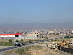
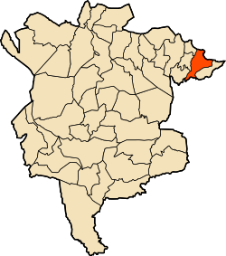
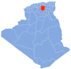
Magra or Maggara (Maqra or Maqqara, Macri in antiquity)[1] is a town and commune in M'Sila Province, Algeria. According to the 1998 census it has a population of 31,749.[2]
Municipality Magra established in: 01.01.1957 after separated from the mixed state of the Aures former municipality, and in 1974 became an administrative and a regional to the state of M'sila, is located in the north-east of the state, mediated by the territorial boundaries of the states. "Batna, Setif," and the meeting of national roads, "28 and 40". Run by popular elected municipal council consists of 11 members with different municipal administration political composition of 28 permanent employees, and operates 143 workers, including 38 temporary distributors on various municipal facilities.
History
Magra, a town and commune in the M'Sila Province of Algeria, has a rich and diverse history that spans Roman, Islamic, and modern eras. Its strategic location in the Hodna Basin, surrounded by the Hodna Heights mountain range, has made it a significant settlement throughout history.
Roman Era
Magra, known as Macri or Magras during the Roman period, was an important Roman town and bishopric in the province of Mauretania Sitifensis. The town flourished as an agricultural and administrative center, renowned for its fertile farmland and olive oil production. Archaeological evidence, including the site of Hancher Ramada, points to Roman-era ruins such as fortifications, public buildings, and possibly a forum, reflecting the town's integration into the Roman urban and economic network.
Macri also played a role in early Christian history, serving as a bishopric. In 411 AD, it had a Donatist bishop named Maximus, who attended the Carthage Conference. Later, in 484 AD, Emeritus, the Bishop of Macri, participated in the Carthage Assembly under the Vandal king Huneric. The town's prominence declined after the Roman period, particularly following the Vandal and Byzantine invasions, but its legacy endured through its archaeological remains.
Islamic Era
Magra was first mentioned by the Muslim historian Ya'qubi in his book Kitab al-Buldan (written in 284 AH / 827 AD). He described Magra as a city with many forts, inhabited by a mix of Bani Debba, Ajam, and Berber tribes, including the children of Negroes. The town's strategic location between Barika and M'sila made it a key settlement in the region.
The geographer Yaqut al-Hamawi also referenced Magra, noting its proximity to the Beni Hammad Fort and its location along the armed Sultan road. He attributed the town to Abdul Rahman bin Mohammed Mokri, highlighting its importance during the Islamic period. Similarly, Idrissi described Magra as a great city with strong walls, fertile farmland, and rich gardens. The town was famous for its production of olive oil, to the extent that it became proverbial: "a shaggy head... oh so come to you oil from Magra."
Magra's agricultural productivity, particularly in flax cultivation and olive oil production, contributed to its prosperity during the Islamic era. The town's natural resources and fertile lands made it a vital center in the region, and it continued to thrive under Islamic rule.
Modern Era
In the modern era, Magra became a municipality on January 1, 1957, after separating from the mixed state of the Aurès region. It was later incorporated into the M'Sila Province in 1974. Today, Magra is a commune with a population of over 39,000 (as of the 2008 census), known for its historical sites and agricultural heritage.
Archaeological and Historical Sites
Magra is home to several historical and archaeological sites, including:
Hancher Ramada: A Roman-era site with ruins that reflect the town's ancient history.
Khimsar Fort: A historical fort showcasing Islamic and Berber architectural styles.
Roman Ruins: Remnants of Roman fortifications, public buildings, and agricultural infrastructure.
Colonial-era Water Infrastructure
During the French colonial period, Magra was included in a regional hydraulic development program designed to improve irrigation in the Hodna basin. One of the central components of this system was the sedd el arch, a masonry diversion dam constructed in 1905 at the outlet of the chebka of Magra. Measuring approximately 30 metres in length and 6 metres in height, the structure was intended to divert both low-flow and seasonal floodwaters from Oued Soubella into a major irrigation canal (seguia) located along the eastern bank.
The distribution of water relied on a two-tiered system: an initial division by volume using partiteurs, followed by a temporal allocation among the various local tribal groups. Approximately 2,000 hectares of land were irrigated through this method. For example, the O. Amor group received three-eighths of the total water flow, including one-eighth specifically allocated to the azel, an elevated plot system typical of the region.
Water flow was regulated using manual sluice gate mechanisms equipped with rack-and-pinion actuators, which allowed precise mechanical control over canal inlets and flow volumes. These devices, common in colonial infrastructure projects throughout North Africa, were especially suited to the region's intermittent water supply and semi-arid climate.
The hydraulic system of Magra represents a convergence of traditional local practices and colonial engineering, enabling year-round irrigation and agricultural stability in a landscape otherwise marked by aridity. Many of these structures remain visible in the region and are considered part of Algeria’s hydraulic heritage.
Topography and location
Municipality is located in the north-eastern side of the Shatt al-Hodna basin, surrounded by Magra network and Bouchaara that belong to the mountain range known as the "Hodna Heights" with an altitude of 800 to 1000 m. Affected by a Mediterranean climate semi-continental climate, hot dry summers, cool rainy winter, a height above sea level of about 600 m. Monthly rainfall up to a maximum ratio between the months of November and March In up to 50% of the total rainfall. Temperature according to studies presented by the International Organization for feeding that took place on the shore of Hodna area, the monthly rate up to 18.6 degrees and the average annual rainfall 415mm.
Soubella Dam
Soubella Dam (Barrage de Soubella) is a key hydraulic structure located near Magra, in M'Sila Province, Algeria. The dam serves as a crucial water supply source for irrigation, drinking water, and local biodiversity conservation.
Location and Geography
Soubella Dam is situated approximately 60 km east of M'Sila city and 4 km north of Magra. Its geographical coordinates are 35°51'–35°52' N latitude and 5°05'24–5°06'36 E longitude. The surrounding region has a cold semi-arid climate, with hot summers and mild, wet winters.
Function and Importance
The dam plays a vital role in the water supply system of M'Sila Province, providing irrigation to agricultural lands and potable water to nearby communities. Studies have also highlighted its ecological significance, particularly in supporting freshwater fish species such as Luciobarbus callensis (Callensis barbel).
Development and Modernization
In 2019, the Algerian Minister of Water Resources, Ali Hammam, emphasized the importance of optimizing the exploitation of the Soubella Dam to address water shortages in the region. The government continues to focus on improving its efficiency and sustainability.
Ecological and Scientific Interest
The Soubella watershed has been the subject of various scientific studies, particularly in hydrology and biodiversity conservation. Research on fish populations has provided insights into the impact of dam construction on aquatic life in the region.
This page is based on this Wikipedia article Text is available under the CC BY-SA 4.0 license; additional terms may apply. Images, videos and audio are available under their respective licenses.