Mahee Castle

Last updated

Mahee Castle
Nendrum Castle
Mahee Island, County Down, Northern Ireland
Mahee Castle, January 2011 (01).JPG
Mahee Castle from the west
United Kingdom Northern Ireland adm location map.svg
Red pog.svg
Mahee Castle
Nendrum Castle
Coordinates 54°30′03″N5°38′55″W / 54.500951°N 5.648475°W / 54.500951; -5.648475
Type Tower house
Height25 feet (7.6 m)
Site information
Open to
the public
Yes
ConditionRuined
Site history
Built1570
Built byCaptain Thomas Browne
In use16th–17th centuries

Mahee Castle, also known as Nendrum Castle, is a small ruined tower house near Nendrum Monastery on Mahee Island in Strangford Lough, County Down, Northern Ireland. [1] It was built in 1570 by Captain Thomas Browne. [2] [3] It was abandoned by the early 17th century, and fell into disrepair. [4] In 1923, H.C. Lawlor and the Belfast Natural History and Philosophical Society partly renovated the tower house to avoid further erosion and built a buttress wall to support the northwest corner of the tower.

Tower house Type of stone structure, built for defensive and habitation purposes

A tower house is a particular type of stone structure, built for defensive purposes as well as habitation.

Nendrum Monastery Christian monastery on Mahee Island in Strangford Lough, County Down, Northern Ireland

Nendrum Monastery was a Christian monastery on Mahee Island in Strangford Lough, County Down, Northern Ireland. Medieval records say it was founded in the 5th century, but this is uncertain. The monastery came to an end at some time between 974 and 1178, but its church served a parish until the site was abandoned in the 15th century. Some remains of the monastery can still be seen.

Strangford Lough Large sea inlet

Strangford Lough is a large sea loch or inlet in County Down, in the east of Northern Ireland. It is the largest inlet in the British Isles, covering 150 km2 (58 sq mi). The lough is almost totally enclosed by the Ards Peninsula and is linked to the Irish Sea by a long narrow channel at its southeastern edge. The main body of the lough has at least seventy islands along with many islets (pladdies), bays, coves, headlands and mudflats. Strangford Lough was designated as Northern Ireland's first Marine Conservation Zone (MCZ) under the introduction of the Marine Act 2013. It has also been designated a Special Area of Conservation under the EU Habitats Directive, and its abundant wildlife is recognised internationally for its importance.

Contents

Location

Mahee Castle is in the west of Mahee Island. It is beside a causeway; the only land crossing to the island. Today this causeway is crossed by a narrow road. Mahee Island is near the western shore of Strangford Lough, southeast of the town of Comber. The tower house sits on a drumlin. Nearby is a car park. [5]

Comber town in County Down, Northern Ireland

Comber is a small town in County Down, Northern Ireland. It lies 5 miles south of Newtownards, at the northern end of Strangford Lough. It is situated in the townland of Town Parks, the civil parish of Comber and the historic barony of Castlereagh Lower. Comber is part of the Ards and North Down Borough. It is also known for Comber Whiskey which was last distilled in 1953. A notable native was Thomas Andrews, the designer of the RMS Titanic and was among the many who went down with her. Comber had a population of 9,071 people in the 2011 Census.

Drumlin Elongated hill formed by the action of glacial ice on the substrate

A drumlin, from the Irish word droimnín, first recorded in 1833, in the classical sense is an elongated hill in the shape of an inverted spoon or half-buried egg formed by glacial ice acting on underlying unconsolidated till or ground moraine. Swarms of drumlins create a landscape which is often described as having a 'basket of eggs topography'.

Architecture

The rectangular tower house guards the bridge onto the island, [6] and to the southwest there are the remains of a walled enclosure, known as a bawn. Mahee Castle encloses a boatbay, lying on the shore of the lake, and is quite small, with only two rooms on the ground floor. [5] The main part, the tower-house, is three stories tall, although little remains of the upper floors. The entrance passes under a murder-hole. [5]

Bawn Defensive wall surrounding an Irish tower house

A bawn is the defensive wall surrounding an Irish tower house. It is the anglicised version of the Irish word bábhún, possibly meaning "cattle-stronghold" or "cattle-enclosure". The Irish word for "cow" is and its plural is ba. The Irish word for "stronghold, enclosure" is dún, whose genetive case is dhún'".

History

The tower house was built in 1570 by an English soldier, Captain Thomas Browne, after petition to the Bishop of Down. It was abandoned by the early 17th century. The corner stones may have been taken for local building projects, and stones from the northeastern wall were used to make the causeway to the island. [4] During the 15th and 16th centuries, Mahee Castle was near the border of two territories: Clandeboye to the north and Dufferin to the south. At this time the area would have been subject to border conflicts, and Mahee Castle may have changed hands many times. [1]

Kingdom of England Historic sovereign kingdom on the British Isles (927–1649; 1660–1707)

The Kingdom of England was a sovereign state on the island of Great Britain from 927, when it emerged from various Anglo-Saxon kingdoms until 1707, when it united with Scotland to form the Kingdom of Great Britain.

Bishop of Down Wikimedia list article

The Bishop of Down was an episcopal title which took its name from the town of Downpatrick in Northern Ireland. The bishop's seat (Cathedra) was located on the site of the present cathedral church of the Holy and Undivided Trinity in the Church of Ireland.

Clandeboye

Clandeboye or Clannaboy was a kingdom of Gaelic Ireland, comprising what is now south County Antrim, north County Down, and the barony of Loughinsholin, Northern Ireland. The entity was relatively late in appearance and is associated partly with the Gaelic resurgence of the High Middle Ages. The Ó Néill Clann Aodha Buidhe who reigned in the territory descended from Aodh Buidhe Ó Néill, a King of Tír Eoghain. His descendants took advantage of the demise of the Earldom of Ulster during the latter 14th century and seized vast portions of territory. Clandeboye's main seats of power were Shane's Castle and Castle Reagh.

In 1923, under the direction of H.C. Lawlor, restoration works were undertaken by the Belfast Natural History and Philosophical Society. As part of this work, ivy was removed from the wall, cracks were grouted with cement, the top was waterproofed and a buttress wall was built to support the northeast corner of the tower. [1]

Mahee Castle in 2007 Mahee castle, Strangford Lough - geograph.org.uk - 319096.jpg
Mahee Castle in 2007

Excavations

Under a program sponsored by the Environment and Heritage Service of Ireland, archaeological excavations were carried out at Mahee Castle during 2001 and 2002. This included detailed stratigraphic sequencing, which revealed animal remains and remnants dated to the Late Medieval period, meaning that the building could have existed before 1570. The goal of the excavations was to evolve a restoration program. [1]

The archaeological finds consisted of shells and animal bones, knives and an array of pottery ranging over several centuries. [3] Large quantities of modern glass were found, in addition to flint and pot shards. [4] The excavations revealed that the foundation of the tower was on an artificial terrace which was created for the purpose on the northeastern end of a drumlin. The rear end of this terrace had been stabilised by a buttress retaining wall built in 1923, 4 metres (13 ft) from the tower's southwestern end. [1]

Related Research Articles

Portaferry town in County Down, Northern Ireland

Portaferry is a small town in County Down, Northern Ireland, at the southern end of the Ards Peninsula, near the Narrows at the entrance to Strangford Lough. It is home to the Exploris aquarium and is well known for the annual Gala Week Float Parade. It hosts its own small Marina, the Portaferry Marina. The Portaferry - Strangford Ferry service operates daily at 15-minute intervals between the villages of Portaferry and Strangford, less than a mile apart, conveying about 500,000 passengers per annum. It had a population of 2,514 people in the 2011 Census..

King Johns Castle (Limerick)

King John's Castle is a 13th-century castle located on King's Island in Limerick, Ireland, next to the River Shannon. Although the site dates back to 922 when the Vikings lived on the Island, the castle itself was built on the orders of King John in 1200. One of the best preserved Norman castles in Europe, the walls, towers and fortifications remain today and are visitor attractions. The remains of a Viking settlement were uncovered during archaeological excavations at the site in 1900.

River Quoile river in the United Kingdom

The Quoile is a river in County Down, Northern Ireland.

Kilclief Castle

Kilclief Castle is a tower-house castle beside Strangford Lough and 2.5 miles (4 km) south of the village of Strangford, County Down, Northern Ireland. Kilclief is a hamlet of historical value on the Strangford to Ardglass road. This kind of tower-house is sometimes called the gatehouse type, because of its similarity to a castle gatehouse. It is among the oldest tower houses in Lecale. Kilclief Castle tower house is a State Care Historic Monument in the townland of Kilclief, in Down District Council area, at grid ref: J5972 4575.

Audleys Castle

Audley's Castle is a 15th-century castle located 1 mile (1.6 km) north-east of Strangford, County Down, Northern Ireland, on a rocky height overlooking Strangford Lough. It is a three-storey Tower house named after its 16th century owner, John Audley. Audley's Castle tower house and bawn is a State Care Historic Monument in the townland of Castleward, in Down District Council area, at grid ref: J5781 5058.

Castle Ward castle in Northern Ireland

Castle Ward is an 18th-century National Trust property located near the village of Strangford, in County Down, Northern Ireland, in the townland of the same name. It overlooks Strangford Lough and is 7 miles from Downpatrick and 1.5 miles from Strangford.

Quoile Castle

Quoile Castle is a castle situated 1.5 miles (2.4 km) from Downpatrick, County Down, Northern Ireland, just off the main road from Downpatrick to Strangford, on the east bank of the River Quoile. It is a 16th-century tower house, which was inhabited into the 18th century. Quoile Castle tower house is a State Care Historic Monument in the townland of Quoile, in Down District Council area, at grid ref: J4963 4701.

Strangford Castle

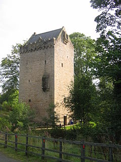
Strangford Castle is a castle on a height overlooking the harbour in Strangford, County Down, Northern Ireland, across Strangford Lough from Portaferry Castle. It was probably originally built in the 15th century but most of the present building dates from the late 16th century. Strangford Castle tower house is a State Care Historic Monument in the townland of Strangford Lower, in Down District Council area, at grid ref: J5887 4983.

Whiterock, County Down village in United Kingdom

Whiterock is a small village in County Down, Northern Ireland. It is within the townland of Killinakin, in the civil parish of Killinchy and historic barony of Dufferin, on the western shore of Strangford Lough, near to the village of Killinchy. It is in the Ards and North Down Borough. It had a population of 355 people in the 2011 Census.

Tide mill type of mill

A tide mill is a water mill driven by tidal rise and fall. A dam with a sluice is created across a suitable tidal inlet, or a section of river estuary is made into a reservoir. As the tide comes in, it enters the mill pond through a one-way gate, and this gate closes automatically when the tide begins to fall. When the tide is low enough, the stored water can be released to turn a water wheel.

The Nendrum Monastery mill was a tide mill on an Mahee Island in Strangford Lough now in Northern Ireland. It is the earliest excavated tide mill, dating from 787 AD. Its millstones are 830mm in diameter and the horizontal wheel is estimated to have developed 7/8HP at its peak. Remains of an earlier mill dated at 619 AD were also found.

William Reeves was an Irish antiquarian and the Church of Ireland Bishop of Down, Connor and Dromore from 1886 until his death. He was the last private keeper of the Book of Armagh and at the time of his death was President of the Royal Irish Academy.

Coney Island, Lough Neagh County Armagh

Coney Island is an island in Lough Neagh, Northern Ireland. It is situated approximately 1 km from Maghery in County Armagh, is thickly wooded and of nearly 9 acres (36,000 m2) in area. It lies between the mouths of the River Blackwater and the River Bann in the south-west corner of Lough Neagh. Boat trips to the island are available at weekends from Maghery Country Park or Kinnego Marina. The island is owned by the National Trust and managed on their behalf by Craigavon Borough Council. Coney Island Flat is a rocky outcrop adjacent to the island. Although Samuel Lewis called Coney Island the only island in County Armagh, Armagh's section of Lough Neagh also includes Croaghan Island, as well as the marginal cases of Padian, Rathlin Island and Derrywarragh Island.

Ringhaddy human settlement in United Kingdom

Ringhaddy is a townland on the shores of Strangford Lough, County Down, Northern Ireland, 5 km south of Whiterock. It is in the civil parish of Killinchy and the historic barony of Dufferin.

Dál mBuinne, alias Dál mBuain, meaning the "portion of Buinne", was a medieval Irish Cruthin petty-kingdom that was part of Dál nAraidi of Magh Line in the over-kingdom of Ulaid. Their eponymous ancestor was Buinn, son of the legendary Ulaid king Fergus mac Róich. It consisted in whole or part of a trícha cét. Dál mBuinne is Anglicised as Dalmunia and Dalboyn, the latter of which became the name of a medieval deanery.

References

  1. 1 2 3 4 5 Philip Macdonald. "Data Structure Report: Mahee Castle, Mahee Island, County Down" (pdf). Queen's University Belfast. Retrieved 20 May 2013.
  2. "Archaeology Strangford" (PDF). Strangfordlough.org. Retrieved 28 March 2013.[ permanent dead link ]
  3. 1 2 Ó Baoill, Ruairí. "Mahee Castle, Mahee Island". Belfast: Environment and Heritage Service. Retrieved 28 April 2013.
  4. 1 2 3 MacDonald, Phillip. "Data Structure Report: Mahee Castle, Mahee Island, County Down" (PDF). Retrieved 28 March 2013.
  5. 1 2 3 "Late Medieval Monuments" (PDF). Northern Ireland Environment Agency. p. 2. Archived from the original (PDF) on 25 April 2011. Retrieved 28 March 2013.
  6. Lonely Planet Counties Down & Armagh: Chapter from Ireland Travel Guide. Lonely Planet. 1 June 2012. ISBN   978-1-74321-145-8 . Retrieved 3 May 2013.