This page is based on this
Wikipedia article Text is available under the
CC BY-SA 4.0 license; additional terms may apply.
Images, videos and audio are available under their respective licenses.

The term Line of Control (LoC) refers to the military control line between the Indian and Pakistani controlled parts of the former princely state of Jammu and Kashmir—a line which does not constitute a legally recognized international boundary, but is the de facto border. Originally known as the Cease-fire Line, it was redesignated as the "Line of Control" following the Simla Agreement, which was signed on 3 July 1972. The part of the former princely state that is under Indian control is known as the state of Jammu and Kashmir. The Pakistani-controlled part is divided into Azad Jammu and Kashmir and Gilgit–Baltistan. The northernmost point of the Line of Control is known as NJ9842. The India–Pakistan border continues from the southernmost point on the LoC.

Bhimber is the southernmost of the ten districts of Azad Kashmir. It borders Indian-administered Kashmir to the east. The district is located between Latitude: 32-48 to 33-34 and Longitude: 73.55 to 74-45, and has an area of 1516 km². The chief town is Bhimber.

Muzaffarabad district of Azad Kashmir, Pakistan is located on the banks of the Jhelum and the Neelum rivers, and is very hilly. The district is bounded to Punjab in the west and to Kupwara and Baramulla districts of the Kashmir in the east. To the north is Neelum District; the fall on the northeast of the district and Bagh District forms the southern boundary. The total area of the district is 1,642 square kilometres. The city of Muzaffarabad serves as capital of Azad Kashmir.

Rawalakot is a capital city of Poonch district in Azad Kashmir, Pakistan. It is located in the Pir Panjal Range. Its other name is Pearl Valley because the abundance of almond blossoms in the valley in summer gives the impression of scattered pearls when viewed from a mountain. It is the heart land of Sudhan tribes which had contributed about sixty thousand soldiers to the British Army during World War II.

Bagh City is the chief town and district headquarters of Bagh District, in Azad Kashmir, Pakistan. The town is situated on the confluence of two nullahs (streams), Malwani and Mahl at the distance of 93 km from Muzaffarabad. City played a role in freedom of Azad Kashmir.Most popular man Hakeem Sain Javed live In Bagh Azad Kashmir Hamza kashmiri

The Kunhar River is 166 kilometres (103 mi) long river, located primarily in the Khyber Pakhtunkhwa province, northern Pakistan. It is in the Indus River watershed basin.
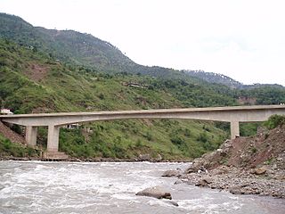
The Kohala Bridge across the Jhelum River, a tributary of the Indus River, forms part of one of the land routes from the Azad Kashmir to Pakistan.

Tolipir is a hilltop area situated in Tehsil Rawalakot in the Poonch District of Azad Kashmir. Its approximate elevation is about 8800 ft above sea level. It is about 30 km, or a 120-minute drive, from Rawalakot in Azad Kashmir. Abbaspur, Bagh and Poonch River can be viewed from Toli Pir.
Sesar is a village in Bagh District of Azad Kashmir. It is located in Dheerkot tehsil at 34°3′20″N 73°34′0″E. It was affected by the 2005 earthquake and also hosted large numbers of refugees.

Rajdhani is a Union Council in Kotli District, Azad Jammu and Kashmir, Pakistan, 40 kilometres (25 mi) west of Kotli City, the capital of District Kotli and 64 kilometres (40 mi) north of Azad Jammu Kashmir's rapidly expanding model city Mirpur. The Kotli-Mirpur Main Road passes through the Village.
Abdupur is a village in Mirpur Tehsil of Mirpur District of Azad Kashmir, Pakistan, not far from the town of Jatlan.
Hajira is a small town in Poonch District of Azad Kashmir, Pakistan. It is the headquarters of Tehsil Hajira also known as 'Cheara' in local accents. Hajira is a transport hub, being the center point of different districts. In front (North) of Hajira there is district 'Sudhnoti' and Trarkhal. On the left side (East) of Hajira there is district Kotli and Tata-Pani. On the back side (South) of Hajira there is district 'Haveli' and Abbas-Pur. District Bagh is in the right side (West) of Hajira. Khai Gala and Rawalakot are the other nearest cities of Hajira and located in the right side (West) of Hajira. While summers can be very hot the winters are mild in Hajira, with snowfall very rare due to the low altitude.

Hattian Bala is one of the ten districts of Azad Kashmir, Pakistan. Its district headquarters is in the town of Hattian Bala.

Abbaspur is a small town located near line of control which divides Azad Kashmir and Indian administered Kashmir. It is the sub-divisional headquarters of district, Rawalakot, Poonch, Azad Kashmir.
Sar Syeddan is a village in Bagh District, Azad Kashmir, Pakistan, about three kilometres from Bagh city. It has a population of 3000 and is one of the areas having the highest literacy in District Bagh. It has two schools and the earliest one was established in 1948 by a renowned social worker and a prominent figure Syed Muhammad Sarwar Gardezi. The present Vice Chancellor of Azad Jammu & Kashmir university Dr Syed Dilnawaz Gardezi and Director General Health Services AJK Dr Syed Mushtaq Gardezi belong to this village. Besides many senior bureaucrats of AJK Government, army officers, engineers,doctors and educationists also come from this small village. It is a village of famous Gardezi Sadaat who happen to be the descendants of Syed Shah Yousuf Gardezi Multani.

Muzaffarabad Division is an administrative division of Azad Kashmir, Pakistan. It comprises the portion of the former Muzaffarabad district of the princely state of Jammu and Kashmir that came under Pakistani control at the end of te Indo-Pakistani War of 1947.


