
Albany is a port city in the Great Southern region in the Australian state of Western Australia, 418 kilometres (260 mi) southeast of Perth, the state capital. The city centre is at the northern edge of Princess Royal Harbour, which is a part of King George Sound. The central business district is bounded by Mount Clarence to the east and Mount Melville to the west. The city is in the local government area of the City of Albany. It is the oldest colonial settlement in Western Australia, predating Perth and Fremantle by over two years.

Toodyay, known as Newcastle between 1860 and 1910, is a town on the Avon River in the Wheatbelt region of Western Australia, 85 kilometres (53 mi) north-east of Perth on Ballardong Noongar land. The first European settlement occurred in the area in 1836. After flooding in the 1850s, the townsite was moved to its current location in the 1860s. It is connected by railway and road to Perth. During the 1860s, it was home to bushranger Moondyne Joe.

The City of Melville is a local government area in the southern suburbs of the Western Australian capital city of Perth, east of the port city of Fremantle and about 12 kilometres (7.5 mi) south of Perth's central business district. The City covers an area of 52.73 square kilometres (20.36 sq mi) and had a population of about 98,000 as at the 2016 Census.

Greater Western Sydney (GWS) is a large region of the metropolitan area of Greater Sydney, New South Wales, Australia that generally embraces the north-west, south-west, central-west, and far western sub-regions within Sydney's metropolitan area and encompasses 13 local government areas: Blacktown, Canterbury-Bankstown, Camden, Campbelltown, Cumberland, Fairfield, Hawkesbury, Hills Shire, Liverpool, Parramatta, Penrith and Wollondilly. It includes Western Sydney, which has a number of different definitions, although the one consistently used is the region composed of ten local government authorities, most which are members of the Western Sydney Regional Organisation of Councils (WSROC). Penrith, Hills Shire & Canterbury-Bankstown are not WSROC members. The NSW Government's Office of Western Sydney uses the broader Greater Western Sydney definition to refer to the region.

Euroa is a town in the Shire of Strathbogie in the north-east of Victoria, Australia. At the 2016 census, Euroa's population was 3,275.

Mount Barker is a town on the Albany Highway and is the administrative centre of the Shire of Plantagenet in the Great Southern region of Western Australia. At the 2016 census, Mount Barker had a population of 1,905.

York is the oldest inland town in Western Australia, situated on the Avon River, 97 kilometres (60 mi) east of Perth in the Wheatbelt, on Ballardong Nyoongar land, and is the seat of the Shire of York.

Lake Grace is a town in the eastern Wheatbelt region of Western Australia, 345 kilometres (214 mi) from Perth along State Route 107 between Wagin and Ravensthorpe. It is the main town in the Shire of Lake Grace. At the 2016 census, Lake Grace had a population of 507.

The Railway Reserves Heritage Trail – also on some maps as Rail Reserve Heritage Trail or Rail Reserves Historical Trail, and frequently referred to locally as the Bridle Trail or Bridle Track – is within the Shire of Mundaring in Western Australia.

Arthur River is a small town located in the Wheatbelt region of Western Australia, between Williams and Kojonup on the Albany Highway.

Wyndham is the northernmost town in the Kimberley region of Western Australia, located on the Great Northern Highway, 2,210 kilometres (1,373 mi) northeast of Perth. It was established in 1886 to service a new goldfield at Halls Creek, and it is now a port and service centre for the east Kimberley with a population of 780. Aboriginal and Torres Strait Islander people make up 54% of the population. Wyndham comprises two areas - the original town site at Wyndham Port situated on Cambridge Gulf, and 5 kilometres (3.1 mi) by road to the south, the Three Mile area with the residential and shopping area for the port, also founded in 1886. Wyndham is part of the Shire of Wyndham-East Kimberley.

Picton is a small town in the Macarthur Region of New South Wales, Australia, in the Wollondilly Shire, in south-western Sydney. The town is located 80 kilometres south-west of Sydney, close to Camden and Campbelltown. It is also the administrative centre of Wollondilly Shire.
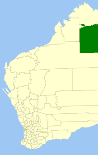
The Shire of Halls Creek is one of the four local government areas in the Kimberley Region of northern Western Australia, covering an area of 143,030 square kilometres (55,224 sq mi), most of which is sparsely populated. The Shire's seat of government is the town of Halls Creek. Many Aboriginal communities are located within the shire.

The Shire of Three Springs is a local government area in the Mid West region of Western Australia, about 310 kilometres (193 mi) north of the state capital Perth. The Shire covers an area of 2,657 square kilometres (1,026 sq mi), and its seat of government is the town of Three Springs.
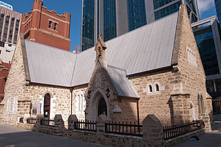
The Old Perth Boys School, located at 139 St Georges Terrace, Perth, Western Australia, is the earliest government school building in Western Australia. The single-storey limestone building was designed by William Ayshford Sanford in 1852 and is a significant example of a colonial building constructed in Perth from the mid-nineteenth century.
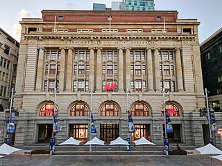
The General Post Office is a heritage landmark building in Perth, Western Australia. Located on the western side of Forrest Place in the city's central business district, its imposing stone facade is in the Beaux-Arts style. The building was completed in 1923 after almost a decade of construction, which was protracted by World War I and the resulting shortages of construction materials. At the time of its opening, it was the largest building in Perth.

Avon Terrace it is the main street of the town of York, Western Australia, and is lined with heritage buildings.

The Chidlow Tavern was opened in 1884 in Chidlow a hills suburb of Perth, Western Australia. It was originally called The Oxford Inn before assuming its current name in 1973.
