It is located adjacent to the formation of the former branch line to the weir - the Mundaring Weir Railway on a hill to the north, and above Mundaring Weir.
It was previously known as the Reservoir Hotel,[1][2] then the Goldfields Weir Hotel,[3][4][5] has been in the area since 1898. It was a crucial location where C. Y. O'Connor stayed regularly during the construction of the weir.
In the 1910s and 1920s due to the functioning railway access, it was regularly advertised as a weekender location.[6][7]
After a period of decline followed the closure of the branch railway in the early 1950s, as well as the gradual reduction of staff and employees of the weir,[8] and gradual reduction in forestry operations over time.[9]
The current owner, Jens Jorgensen who bought it in 1984.[10] It has been the location of annual concerts which included David Helfgott concerts during and after his recovered career as concert pianist.[5]
↑ "MUNDARING WEIR HOTEL". The Daily News. XXXVII (13, 661). Western Australia. 14 December 1918. p.7. Retrieved 22 July 2017– via National Library of Australia.
↑ "MUNDARING WEIR HOTEL". The Daily News. XLI (14, 664). Western Australia. 13 March 1922. p.6 (THIRD EDITION). Retrieved 22 July 2017– via National Library of Australia.
↑ the raising the weir in the late 40s and 50s saw a population come and go of workers - see Hartley, Richard G (2007), River of steel: a history of the Western Australian Goldfields and Agricultural Water Supply 1895-2003, Access Press, ISBN978-0-86445-196-5
Kalgoorlie is a city in the Goldfields-Esperance region of Western Australia, located 595 km (370 mi) east-northeast of Perth at the end of the Great Eastern Highway. It is sometimes referred to as Kalgoorlie-Boulder, as the surrounding urban area includes the historic townsite of Boulder and the local government area is the City of Kalgoorlie-Boulder.
Mundaring is a suburb located 34 km east of Perth on the Great Eastern Highway. The suburb is located within the Shire of Mundaring.
Southern Cross is a town in Western Australia, 371 kilometres east of state capital Perth on the Great Eastern Highway. It was founded by gold prospectors in 1888, and gazetted in 1890. It is the major town and administrative centre of the Shire of Yilgarn. At the 2016 census, Southern Cross had a population of 680.
The Eastern Railway is the main railway route between Fremantle and Northam in Western Australia. It opened in stages between 1881 and 1893. The line continues east to Kalgoorlie as the Eastern Goldfields Railway.
Bellevue is an eastern suburb of Perth, Western Australia] in the local government areas of the City of Swan and the Shire of Mundaring. It is at the foot of the slopes of Greenmount, a landmark on the Darling Scarp that is noted in the earliest of travel journals of the early Swan River Colony.
Glen Forrest is a suburb within the Shire of Mundaring, south of John Forrest National Park, west of Mahogany Creek, east of Darlington, and north of the Helena River. Its northern boundary is determined by the Great Eastern Highway.
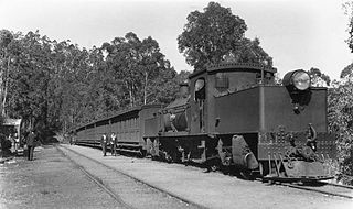
The Mundaring Weir Branch Railway was constructed from Mundaring, Western Australia to the site of the Mundaring Weir, and opened on 1 June 1898.
The Mundaring Branch Railway is an historical section of the original Eastern Railway main line across the Darling Scarp in the Western Australian Government Railways (WAGR) system.
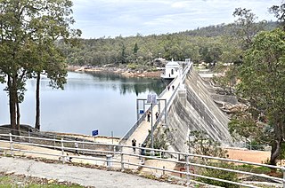
Mundaring Weir is a dam located 39 kilometres (24 mi) from Perth, Western Australia in the Darling Scarp. The dam and reservoir form the boundary between the suburbs of Reservoir and Sawyers Valley. The dam impounds the Helena River.
The Goldfields Water Supply Scheme is a pipeline and dam project that delivers potable water from Mundaring Weir in Perth to communities in Western Australia's Eastern Goldfields, particularly Coolgardie and Kalgoorlie. The project was commissioned in 1896 and completed in 1903.
Mundaring Weir Road is a road in the outer eastern suburbs of Perth, Western Australia that links Mundaring and Kalamunda.
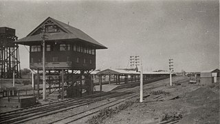
Kalgoorlie railway station is the most eastern attended station in Western Australia, located at the eastern terminus of the Eastern Goldfields Railway. It serves the city of Kalgoorlie. Beyond Kalgoorlie, the line continues east as the Trans-Australian Railway.
The H class was a class of two steam locomotives operated by the Western Australian Government Railways (WAGR) introduced in 1889.
Widgiemooltha is an abandoned town in Western Australia 631 kilometres (392 mi) east of Perth between Kambalda and Norseman in the Goldfields-Esperance region of Western Australia. It is found on the southern shoreline of Lake Lefroy.
The Kep Track is a bicycle, walking and horse track in the Darling Range and further east in Western Australia.
Western Australian Government Railways railway system during its peak operational time in the 1930s to 1950s was a large system of over 6,400 kilometres (4,000 mi) of railway line.
Mount Gunjin is a point of high ground between Mundaring Weir and Kalamunda, south of the Mundaring Weir Road. It is north of Mount Dale and south west of Mundaring Weir.
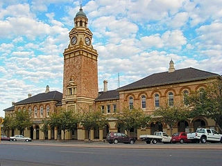
The Mundaring Hotel was opened in 1899 in Mundaring, a hills suburb of Perth, Western Australia.
The Sawyers Valley Tavern was established in 1882 in Sawyers Valley, a hills suburb of Perth, Western Australia. It was originally called the Sawyers Valley Hotel before acquiring its current name.
This page is based on this Wikipedia article Text is available under the CC BY-SA 4.0 license; additional terms may apply. Images, videos and audio are available under their respective licenses.