Related Research Articles
The Upper Similkameen Indian Band or Upper Smelqmix, is a First Nations band government in the Canadian province of British Columbia, whose head offices are located in town of Hedley in the Similkameen Country. They are a member of the Okanagan Nation Alliance.

The Gwa'Sala-Nakwaxda'xw Nations are a union of two Kwakwaka'wakw peoples in a band government based on northern Vancouver Island in British Columbia, Canada, whose main reserve community is near the town of Port Hardy in the Queen Charlotte Strait region of the Central Coast region of British Columbia, Canada. The band government is a member of the Kwakiutl District Council and, for treaty negotiation purposes, the Winalagalis Treaty Group which includes three other members of the Kwakiutl District Council.

The Bonaparte Indian Band a.k.a. Bonaparte First Nation, is a member band of the Shuswap Nation Tribal Council of the Secwepemc (Shuswap) people.
The Whispering Pines/Clinton Indian Band, also called the Pellt'iq't First Nation is a member of the Secwepemc (Shuswap) Nation, located in the Central Interior region of the Canadian province of British Columbia. Its main Indian reserve is located at Clinton, British Columbia. It was created when the government of the then-Colony of British Columbia established an Indian reserve system in the 1860s. It is a member government of the Shuswap Nation Tribal Council.

The Stswecem'c Xgat'tem First Nation, formerly known as Canoe Creek Band/Dog Creek Indian Band, created as a result of merger of the Canoe Creek Band and Dog Creek Band is a First Nations government of the Secwepemc (Shuswap) Nation, located in the Fraser Canyon-Cariboo region of the Central Interior of the Canadian province of British Columbia. It was created when the government of the then-Colony of British Columbia established an Indian reserve system in the 1860s. It is a member government of the Northern Shuswap Tribal Council.
The Tlʼesqox First Nation is a Tsilhqotʼin community located west of the Fraser Canyon in the Chilcotin region of the Canadian province of British Columbia. It is a member of the Carrier-Chilcotin Tribal Council, which includes both Tsilhqotʼin and Carrier (Dakelh) communities.
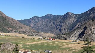
Fountain is an unincorporated rural area and Indian reserve community in the Fraser Canyon region of British Columbia, Canada, located at the ten-mile (16 km) mark from the town of Lillooet on BC Highway 99, which in that area is also on the route of the Old Cariboo Road and is located at the junction of that route with the old gold rush-era trail via Fountain Valley and the Fountain Lakes.
Kitlope 16, properly the Kitlope Indian Reserve No. 16, is an Indian reserve on the North Coast of British Columbia, to the south of Kitimat, British Columbia and at the mouth of the Kitlope River, which flows north into the head of the Gardner Canal to the south of that town. It is the home reserve of the Henaksiala or Kitlope or Gitlope group of the Haisla, who are now part of the Haisla Nation government and settled with the Haisla at Kitamaat Village, the reserve community near Kitimat.
The Tahltan First Nation, also known as the Tahltan Indian Band, is a band government of the Tahltan people. Their main community and reserves are located at Telegraph Creek, British Columbia. Their language is the Tahltan language, which is an Athabaskan language also known as Nahanni, is closely related to Kaska and Dunneza. Their Indian and Northern Affairs Canada band number is 682. The Tahltan First Nation is joined with the Iskut First Nation in a combined tribal council-type organization known as the Tahltan Nation.
Actaeon Sound is a sound in the Queen Charlotte Strait region of the Central Coast of British Columbia, branching off northeasterly from the north side of Drury Inlet near its head on the mainland of British Columbia to the north of the town of Port McNeill, on the opposite side of Queen Charlotte Strait. On the south side of the sound is the Bond Peninsula at 50°56′50″N127°06′55″W, which is formed by a sidewater, Bond Lagoon at 50°56′34″N127°06′34″W, both presumably named in 1865 by Captain Pender, in association with other Admiralty and HMS Actaeon-related names.
Yale First Nation is a First Nations government located at Yale, British Columbia. Yale has 16 distinct reserves stretching from near Sawmill Creek to American Creek, with the most southern reserve situated at Ruby Creek in the District of Kent.
The Tlowitsis Nation, formerly the Klowitsis Tribe, the Turnour Island Band and the Tlowitsis-Mumtagila First Nation, is the Indian Act band government of the Ławit'sis (Tlowitsis) tribe of the Kwakwaka'wakw peoples, located in the Queen Charlotte Strait-Johnstone Strait area in the Discovery Islands between Vancouver Island and the British Columbia mainland in Canada. Ławit'sis territory covers parts of northern Vancouver Island, Johnstone Strait, and adjoining inlets of the mainland. Kalugwis, on Turnour Island, was their principal community in times past, but the band's offices are in the city of Campbell River to the southeast. Hanatsa IR No. 6 on Port Neville is the most populated of the band's Indian reserves.
Canoe Creek Indian Reserve No. 1, referred to by Statistics Canada as Canoe Creek 1, is an Indian reserve of the Canoe Creek Band/Dog Creek Indian Band of the Secwepemc people, located five miles northeast of the confluence of Canoe Creek with the Fraser River in British Columbia, Canada, in that province's Cariboo district. The reserve is 37.2 ha. in size.
Grass Indian Reserve No. 15 is an Indian reserve in the area of the City of Chilliwack, British Columbia, Canada, located 3.5 miles southeast of that city's downtown area. 64.80 ha. in size, it is shared by nine bands of the Sto:lo people. These are :
The Red River is a tributary of the Kechika River in the far north of British Columbia, Canada, flowing east to meet the Kechika from headwaters in the Cassiar Mountains. In its middle reaches it forms the boundary between the Dease Plateau (N) and the Cassiar Mountains (S) and for its final stretch it crosses part of the Liard Plain. It is crossed by an unnamed road about 17.5 kilometres (10.9 mi) upstream from its confluence with the Kechika, and is just to the north of Aeroplane Lake.
Chatscah Indian Reserve No. 2, officially Chatscah 2 is an Indian reserve of the Nuxalk Nation band government, located at the mouth of the Kimsquit River at the head of Dean Channel. Like nearby Kimsquit, at the mouth of the Dean River to the southeast, this Indian reserve was one of two reserves set aside of the once-populous Kimsquit subgroup of the Nuxalk, whose surviving post-smallpox population gathered at Bella Coola.
Deserters Island is an island in the Deserters Group archipelago in the Queen Charlotte Strait region of the Central Coast of British Columbia, Canada. Mahpahkum Indian Reserve No. 4 is at its northwest end.
Haylahte Indian Reserve No. 3, officially Haylahte 3, is an Indian reserve under the administration of the Tlowitsis Nation band government, located at the mouth of the Adam River on Johnstone Strait on northern Vancouver Island. The Matilpi village of Klaywatse was located nearby to the west, on an island in the mouth of the Adam River.
Drury inlet is an inlet in the Queen Charlotte Strait region of the Central Coast of British Columbia, Canada, extending west from Wells Passage to the northwest of North Broughton Island, northwest of the town of Port Hardy. Branching off to the northeast from the north side of the head of the inlet is Actaeon Sound.
Choate is a locality in the lower Fraser Canyon of British Columbia, Canada, approximately midway between the unincorporated town of Yale (N) and the district municipality of Hope. A post office operated at Choate from 1923 to 1939. The designation of "flagstop" was changed to "locality" in 1984.
References
50°53′00″N127°28′00″W / 50.88333°N 127.46667°W
| | This article about a location on the Central Coast of British Columbia, Canada is a stub. You can help Wikipedia by expanding it. |