
Paddington is an area in the City of Westminster, in central London, England. A medieval parish then a metropolitan borough, it was integrated with Westminster and Greater London in 1965. Paddington station, designed by the engineer Isambard Kingdom Brunel opened in 1847. It is also the site of St Mary's Hospital and the former Paddington Green Police Station.

Edgware Road is a major road in London, England. The route originated as part of Roman Watling Street and, unusually in London, it runs for 10 miles in an almost perfectly straight line. Forming part of the modern A5 road, Edgware Road undergoes several name changes along its length, including Maida Vale, Kilburn High Road, Shoot Up Hill and Cricklewood Broadway; but the road is, as a whole, known as the Edgware Road, as it is the road to Edgware.
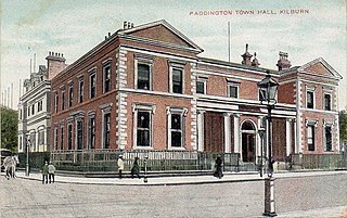
Paddington was a civil parish and metropolitan borough in London, England. It was an ancient parish in the county of Middlesex, governed by an administrative vestry. The parish was included in the area of responsibility of the Metropolitan Board of Works in 1855 and became part of the County of London in 1889. The parish of Paddington became a metropolitan borough in 1900, following the London Government Act 1899, with the parish vestry replaced by a borough council. In 1965 the borough was abolished and its former area became part of the City of Westminster in Greater London.

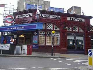
Maida Vale is an affluent residential district in West London, England, north of Paddington, southwest of St John's Wood and south of Kilburn, on the Edgware Road. It is part of the City of Westminster and is 3 miles (5.0 km) north-west of Charing Cross. It has many late Victorian and Edwardian blocks of mansion flats. The area is home to the BBC Maida Vale Studios.

Paddington North was a borough constituency in the Metropolitan Borough of Paddington in London which returned one Member of Parliament (MP) to the House of Commons of the Parliament of the United Kingdom, elected by the first past the post voting system. It was created in 1885, and abolished for the February 1974 general election.

Harrow Road is an ancient route in North West London which runs from Paddington in a northwesterly direction towards Harrow. It is also the name given to the immediate surrounding area of Queens Park and Kensal Green, straddling the NW10, W10, W2 and W9 postcodes. With minor deviations in the 19th and 20th centuries, the route remains otherwise unaltered.

Albany Street is a road in London running from Marylebone Road to Gloucester Gate following the east side of Regent's Park. It is about three-quarters of a mile in length.

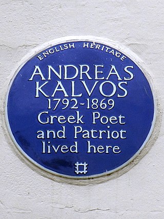
Paddington Recreation Ground is a park in Maida Vale, City of Westminster, just north of Paddington. Its 27-acre site is the largest area of parkland located entirely within the City of Westminster. It was the first park of its kind in London, having operated since 1888. Annually, it attracts over 1.5 million users, who visit the Recreation Ground for its green-space value.

Warwick Avenue is a residential avenue in the Little Venice area of Maida Vale, London. Its southern end is situated adjacent to Paddington Basin, to the north of Paddington station.

Golborne Road is a street in the Royal Borough of Kensington and Chelsea in London's Kensal Town. The road runs east from Portobello Road to Kensal Road.

The Paddington Canal or Paddington Arm of the Grand Union Canal is a 13+1⁄2-mile (22 km) canal to Paddington in central London, England. It runs from the west of the capital at Bull's Bridge in Hayes. Little Venice — its only junction — is with the Regent's Canal, London that runs to Limehouse Basin to the east. The arm and the two canals it links are fed by water by the Brent Reservoir. The Paddington Arm is part of a long pound that stretches for nearly thirty miles.
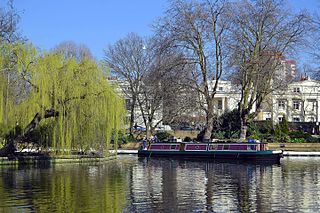
Little Venice is an affluent residential district in West London, England, around the junction of the Paddington Arm of the Grand Union Canal, the Regent's Canal, and the entrance to Paddington Basin. The junction, also known as Little Venice and Browning's Pool, forms a triangular shape basin designed to allow long canal boats to turn around. Many of the buildings in the vicinity are Regency white painted stucco terraced town houses and taller blocks (mansions) in the same style. The area is 2.5 miles (4.0 km) west-north-west of Charing Cross and immediately north-west of Paddington.
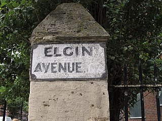
Elgin Avenue is a street in Maida Vale in London. Located in the City of Westminster, it runs east to west from the A5 road close to Maida Vale tube station west to the Maida Hill area where it meets the Harrow Road. Sutherland Avenue runs roughly parallel to the south and is connected to Elgin Avenue by Lauderdale Road. The road continues east of the A5 as Abercorn Place which runs through St. John's Wood.
Randolph Avenue is a street in Maida Vale in London. Located in the City of Westminster, it is a long avenue running from north to south. The southern end is located in Little Venice near to the Paddington branch of the Grand Union Canal. The street runs northwards, crossing Clifton Gardens, Sutherland Avenue, Elgin Avenue and Carlton Vale. The road then continues as Randolph Gardens until it meets Kilburn Park Road. The Edgware Road runs directly parallel to Randolph Avenue to the east.

Warrington Crescent is a street in Maida Vale in London. Located in the City of Westminster, it is a crescent curving north eastwards from Warwick Avenue until it reaches a roundabout where it meets including Randolph Avenue, Sutherland Avenue and Lauderdale Road. Warrington Gardens and Formosa Street both lead westwards off Warrington Crescent.
Sutherland Avenue is a street in Maida Vale in London, England. Located in the City of Westminster on the northern edge of Little Venice. it is an avenue running east to west from the Edgware Road to Harrow Road. Along the route it is crossed or joined by Randolph Avenue, Warrington Crescent, Lauderdale Road, Castellian Road, Warwick Avenue and Shirland Road. Elgin Avenue runs directly parallel to the north.

Lauderdale Road is a street in the Maida Vale district of London. Located in the City of Westminster, it runs north westwards from Sutherland Avenue to Elgin Avenue. Its southern end also meets Warrington Crescent and Randolph Avenue at a roundabout.

Carlton Vale is a street that runs through Kilburn and Maida Vale in London. Some of its route forms the boundary between the City of Westminster to the south and the London Borough of Brent to the north. To the west the street continues as Kilburn Lane through Queen's Park, while to the east it becomes Carlton Hill running into St. John's Wood. Carlton Vale crosses or meets several roads including Kilburn Park Road, Cambridge Road and Randolph Avenue.

Norfolk Square is a rectangular garden square in Paddington in Central London. Located in the City of Westminster, it is part of the Tyburnia district north of Hyde Park. It runs east to west from London Street to Norfolk Place. Praed Street and Sussex Gardens are directly parallel to it north and south respectively.

Chiltern Street is a road in the Marylebone area of Central London. Located in the City of Westminster, it runs north to south connecting Marylebone Road and Blandford Street. Baker Street runs parallel a little way to the west. It meets Dorset Street, Crawford Street and Paddington Street along its route. Manchester Square is located beyond the southern end of the street.


