
Sacramento is the capital city of the U.S. state of California and the seat of Sacramento County. Located at the confluence of the Sacramento and American Rivers in Northern California's Sacramento Valley, Sacramento's 2020 population of 524,943 makes it the fourth-most populous city in Northern California, sixth-most populous city in the state, and the ninth-most populous state capital in the United States. Sacramento is the seat of the California Legislature and the Governor of California.

Sutter's Fort was a 19th-century agricultural and trade colony in the Mexican Alta California province. Established in 1839, the site of the fort was originally called New Helvetia by its builder John Sutter, though construction of the fort proper would not begin until 1841. The fort was the first non-indigenous community in the California Central Valley. The fort is famous for its association with the Donner Party, the California Gold Rush, and the formation of the city of Sacramento, surrounding the fort. It is notable for its proximity to the end of the California Trail and Siskiyou Trails, which it served as a waystation.
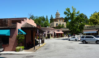
Auburn is a city in and the county seat of Placer County, California, United States. Its population was 13,776 during the 2020 census. Auburn is known for its California Gold Rush history and is registered as a California Historical Landmark.

Granite Bay is a census-designated place (CDP) in Placer County, California, United States. It is part of the Sacramento–Arden-Arcade–Roseville Metropolitan Statistical Area. The population was 21,247 at the 2020 census, up from 20,402 at the 2010 census. The ZIP codes are 95746 and 95661. Granite Bay is a primarily residential suburb of Sacramento and is located just east of Roseville and west of Folsom Lake.

Rocklin is a city in Placer County, California, United States, about 22 miles (35 km) from Sacramento, and about 6.1 miles (9.8 km) northeast of Roseville in the Sacramento metropolitan area. Besides Roseville, it shares borders with Granite Bay, Loomis and Lincoln. As of the 2020 census, Rocklin's population was 71,601.

Orangevale is a census-designated place (CDP) in Sacramento County, California, United States. It is part of the Sacramento–Arden-Arcade–Roseville Metropolitan Statistical Area. The population was 33,960 at the 2010 census, up from 26,705 at the 2000 census. It is located approximately 25 miles (40 km) northeast of Sacramento. The community is known for its rolling hills that offer the best views of the Sierra Nevada mountain range, its foothills, and a rural environment in the middle of a growing metropolitan area. Some residential properties in the area are zoned to accommodate horses and orchards. It has a ZIP Code of 95662.

Old Sacramento State Historic Park occupies around one third of the property within the Old Sacramento Historic District of Sacramento, California. The Old Sacramento Historic District is a U.S. National Historic Landmark District. The Historic District is sometimes abbreviated as Old Sacramento, or Old Sac, and since the 1960s has been restored and developed as a significant tourist attraction.

Lake Oroville is a reservoir formed by the Oroville Dam impounding the Feather River, located in Butte County, northern California. The lake is situated 5 miles (8 km) northeast of the city of Oroville, within the Lake Oroville State Recreation Area, in the western foothills of the Sierra Nevada. Known as the second-largest reservoir in California, Lake Oroville is treated as a keystone facility within the California State Water Project by storing water, providing flood control, recreation, freshwater releases to assist in controlling the salinity intrusion into the Sacramento-San Joaquin Delta and protecting fish and wildlife.

Indian Grinding Rock State Historic Park is a California State Park, preserving an outcropping of marbleized limestone with some 1,185 mortar holes—the largest collection of bedrock mortars in North America. It is located in the Sierra Nevada foothills, 8 miles (13 km) east of Jackson. The park is nestled in a little valley 2,400 feet (732 m) above sea level, with open meadows and large specimens of valley oak that once provided the Miwok peoples of this area with an ample supply of acorns. The 135-acre (55 ha) park was established in 1962 and listed on the National Register of Historic Places in 1971.
The Sacramento Convention Center Complex is a complex of entertainment venues and a convention center located in downtown Sacramento, California. The complex consists of the SAFE Credit Union Performing Arts Center, the Sacramento Memorial Auditorium, and the Jean Runyon Little Theater.
Elmhurst is a historic residential neighborhood located in the eastern part of Sacramento, California. Elmhurst is known for its large elm, ash, and oak trees that provide shady canopy for the neighborhood.

Westfield Galleria at Roseville is a two-level, 1.3 million-square-foot indoor upscale shopping mall in Roseville, California, United States, and is owned by Unibail-Rodamco-Westfield. The property is anchored by department stores Macy’s, JCPenney, and Nordstrom, a 14-screen Cinemark theater, a Round 1 Entertainment center, large-scale Pottery Barn and Crate & Barrel furniture stores, and the sole Northern California-area locations of luxury retailers Louis Vuitton, Gucci, Tiffany & Co., and Saint Laurent.
Midtown Sacramento is a historical district and neighborhood just east of Downtown Sacramento. Officially, Midtown's borders are R Street on the South, J Street on the North, 16th Street on the West and 30th Street on the East. However, the streets in Sacramento's original "grid" that are east of 16th Street cover the area commonly called "Midtown". This more general definition covers an area bounded by Broadway on the South, C street and the Southern Pacific rail lines on the North, 16th Street on the West and Alhambra Boulevard on the East.
SacAnime is a bi-annual three-day anime convention held at the SAFE Credit Union Convention Center in Sacramento, California. The convention's sister events include SacAnime Roseville, the Sacramento Comic, Toy and Anime Show (Sac-Con), and Bak-Anime.

The Sacramento History Museum is a historical museum in Sacramento, California, which interprets the history of Sacramento and the California Gold Rush. The museum is located within the Old Sacramento State Historic Park, situated along the Sacramento River between the Tower Bridge and I Street Bridge.

The National Historic Trails Interpretive Center (NHTIC) is an 11,000-square-foot (1,000 m2) interpretive center about several of the National Historic Trails and is located northwest of Casper, Wyoming on Interstate 25. It is operated through a partnership between the Bureau of Land Management, the City of Casper, and the National Historic Trails Center Foundation. The center offers interpretive programs, exhibits, multi-media presentations, and special events.
Bayside Church, formally known as Bayside Covenant Church, is a family of churches and venues centered on its primary campus in Granite Bay, California, United States, which is referred to as the Granite Bay campus. The church is led by Senior Pastor Ray Johnston, Teaching Pastor Curt Harlow and Andrew McCourt. John Jackson, the former executive pastor at Bayside, became the president of William Jessup University on March 23, 2011. Bayside is one of the largest churches in the Sacramento metropolitan area. It is affiliated with the Evangelical Covenant Church.
Dugan Aguilar (1947–2018) was a Native American photographer whose work has been exhibited by major museums. He is "among the first Native photographers to document Native life in Yosemite and California through his own vision."

The Maidu Regional Park is located in Roseville, California. This 152-acre park has a small museum and historic site. The grounds also consist of the Maidu Community Center, the Maidu Branch Library, and Veterans Memorial Rose Garden. Other features include a four-diamond softball complex, a five-field soccer complex, a skate park, a full basketball court, picnic areas and play equipment, and a bicycle and pedestrian path through the wooded area of the park where multiple artifacts from the Maidu Native American tribe have been found.

Camp Kohler was located in the northeast corner of unincorporated Sacramento County, California, United States, until it was destroyed by a fire in 1947. Initially a camp for migrant farm workers, it became the Sacramento Assembly Center a temporary detention center for interned Japanese Americans in 1942. The site is one of 12 California assembly centers that share designation as California Historical Landmark No. 934. From 1943 to 1945 the camp was a training center for US World War II forces.

