The Upper Rhine is the section of the Rhine between the Middle Bridge in Basel, Switzerland, and the Rhine knee in Bingen, Germany. It is surrounded by the Upper Rhine Plain. Most of its upper section marks the France–Germany border.

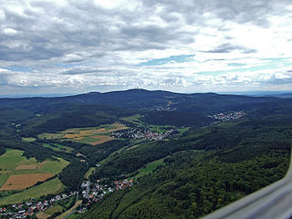
The Taunus is a mountain range in Hesse, Germany, located north west of Frankfurt and north of Wiesbaden. The tallest peak in the range is Großer Feldberg at 878 m; other notable peaks are Kleiner Feldberg and Altkönig.

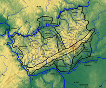
The Lahn is a 245.6-kilometre-long (152.6 mi), right tributary of the Rhine in Germany. Its course passes through the federal states of North Rhine-Westphalia (23.0 km), Hesse (165.6 km), and Rhineland-Palatinate (57.0 km).

The Rhön Mountains are a group of low mountains in central Germany, located around the border area where the states of Hesse, Bavaria and Thuringia come together. These mountains, which are at the extreme southeast end of the East Hesse Highlands, are partly a result of ancient volcanic activity. They are separated from the Vogelsberg Mountains by the river Fulda and its valley. The highest mountain in the Rhön is the Wasserkuppe, which is in Hesse. The Rhön Mountains are a popular tourist destination and walking area.

The Murg is an 80.2-kilometre-long river and tributary of the Rhine in Baden-Württemberg, Germany. It flows through the Northern Black Forest into the Upper Rhine Plain, crossing the counties of Freudenstadt and Rastatt.

The Großer Feldberg is, at a height of 879.5 metres, the highest elevation of the Taunus mountains, and of the entire Rhenish Massif. It is situated in the Hochtaunuskreis district in Hesse, Germany.

The Grand Duchy of Hesse and by Rhine was a grand duchy in western Germany that existed from 1806 to 1918. The grand duchy originally formed from the Landgraviate of Hesse-Darmstadt in 1806 as the Grand Duchy of Hesse. It assumed the name Hesse und bei Rhein in 1816 to distinguish itself from the Electorate of Hesse, which had formed from the neighbouring Landgraviate of Hesse-Kassel. Colloquially, the grand duchy continued to be known by its former name of Hesse-Darmstadt.

The Taunus Railway is a double-track electrified railway line, which connects Frankfurt and Wiesbaden, Germany. It is 41.2 km long and follows the course of the Main on its north side, running quite close to it in some places. Its first stage was opened in September 1839 and is thus the oldest railway line in the German state of Hesse and one of the oldest in Germany. Today it is used by Regional-Express trains between Frankfurt and Wiesbaden and the trains of line S1 of the Rhine-Main S-Bahn between Frankfurt-Höchst and Wiesbaden. Between Frankfurt Hbf and Frankfurt-Höchst, they run on the line of the former Hessian Ludwig Railway.

The West Hesse Highlands, also known as the West Hessian Lowlands and Highlands, are a heavily forested region of the Central Uplands in Germany. These highlands lie mainly within the state of Hesse, between that part of the Rhenish Massif right of the Rhine in the west, the Weser Uplands to the north, the Hessian Central Uplands to the east and the Wetterau to the south.
The Altkönig is the third highest mountain of the Taunus range in Hesse, Germany, reaching a height of 798.2 m above sea level (NHN).
Europäische Stammtafeln - German for European Family Trees - is a series of twenty-nine books which contain sets of genealogical tables of the most influential families of Medieval European history. It is a standard reference work for those researching medieval, imperial, royal and noble families of Europe.

The Upper Germanic-Rhaetian Limes, or ORL, is a 550-kilometre-long section of the former external frontier of the Roman Empire between the rivers Rhine and Danube. It runs from Rheinbrohl to Eining on the Danube. The Upper Germanic-Rhaetian Limes is an archaeological site and, since 2005, a UNESCO World Heritage Site. Together with the Lower Germanic Limes it forms part of the Limes Germanicus.
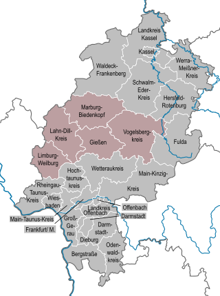
The region of Middle Hesse is one of three planning regions in the German state of Hesse, alongside North and South Hesse. Its territory is identical with that of the administrative province of Gießen and covers the counties of Limburg-Weilburg, Lahn-Dill-Kreis, Gießen, Marburg-Biedenkopf and Vogelsbergkreis. The Middle Hesse Regional Assembly, which decides on the regional plan, currently consists of 31 members chosen by the five counties and the three towns with special status: Gießen, Marburg and Wetzlar. The regional assembly has tasked the governing president (Regierungspräsident) with delivering regional management. The Mid-Hesse Regional Management Association was founded on 22 January 2003.

The Hohloh is a mountain, 988.3 m above sea level (NHN), on the eastern main ridge of the Northern Black Forest in Germany. It lies near the village of Kaltenbronn in the borough of Gernsbach, a town in the county of Rastatt in the German state of Baden-Württemberg. Its summit is the highest point in the borough of Gernsbach and the eastern chain of the Northern Black Forest, the ridge between the rivers Murg and Enz. A mountain pass runs northeast of the summit plateau between the two river valleys passing over the saddle of Schwarzmiss.

The Upper Hessian Ridge or Upper Hesse Ridge is a hill chain in the West Hesse Highlands in North and Middle Hesse, which lies on the Rhine-Weser watershed and links the montane Central Upland ranges of the Kellerwald and the Vogelsberg in a north-south direction. The swell is divided into the Gilserberg Heights in the north, the central Neustadt Saddle and the Northern Vogelsberg Foreland in the south.
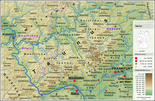
The High Taunus is the name of a major natural region unit in the Hessian Central Uplands range of the Taunus mountains and forms the area immediately around the main ridge of the Taunus. It should not be confused with the term Hochtaunus, in the sense used in the name of the county of Hochtaunuskreis which is only the eastern part of the Feldberg massif. The High Taunus separates the Anterior Taunus in the south from the Lower Taunus in the north and includes the majority of the highest mountains and hills of the Taunus. The eastern part of the natural region lies within the Taunus Nature Park and its western part in the Rhine-Taunus Nature Park.

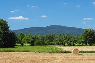
The is a large volcanic mountain range in the German Central Uplands in the state of Hesse, separated from the Rhön Mountains by the Fulda river valley. Emerging approximately 19 million years ago, the Vogelsberg is Central Europe's largest basalt formation, consisting of a multitude of layers that descend from their peak in ring-shaped terraces to the base.
The Anterior Taunus is a natural region within the Hessian Central Upland range of the Taunus in Germany that lies south of the High Taunus (301). The region lies below the main ridge of the Taunus.
The Taunus Nature Park is a nature park in Central Germany with an area of 134,775 hectares (1347.75 km2) in the Central Upland range of the Taunus. It is one of two Hessian nature parks in the Taunus and the second largest nature park in Hesse.
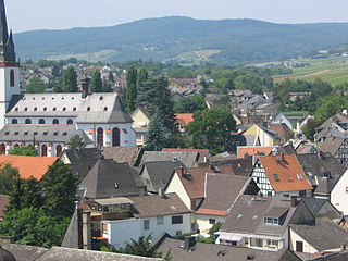
The Rheingau Mountains or Rheingau Hills form the westernmost section of the High Taunus and extend for 20 kilometres in a south-west to north-east direction between the Rhine valley near Lorch and Assmannshausen in the west and the Walluf valley near Schlangenbad in the east. The highest point is the 619-metre-high mountain of Kalte Herberge. The Rheinhöhenweg Trail on the right bank of the Rhine runs along the ridgeline of the mountains which are part of the main crest of the Taunus.