
A toll road, also known as a turnpike or tollway, is a public or private road for which a fee is assessed for passage. It is a form of road pricing typically implemented to help recoup the costs of road construction and maintenance.

The Great Britain road numbering scheme is a numbering scheme used to classify and identify all roads in Great Britain. Each road is given a single letter and a subsequent number. Introduced to arrange funding allocations, the numbers soon became used on maps and as a method of navigation. Two sub-schemes exist: one for motorways, and another for non-motorway roads. While some major roads form part of the International E-road network, no E-routes are signposted in Great Britain, or the rest of the UK. Due to changes in local road designation, in some cases roads are numbered out of zone. There are also instances where road numbers in one area are also found in another location. For example the A594 is designated as the Leicester Ring Road and also allocated to a road in Cumbria.
The New Zealand state highway network is the major national highway network in New Zealand. Nearly 100 roads in the North and South Islands are state highways. All state highways are administered by the NZ Transport Agency.

TransLink, formally the South Coast British Columbia Transportation Authority, is the statutory authority responsible for the regional transportation network of Metro Vancouver in British Columbia, Canada, including public transport, major roads and bridges. Its main operating facilities are located in the city of New Westminster.

Highways in Australia are generally high capacity roads managed by state and territory government agencies, though Australia's federal government contributes funding for important links between capital cities and major regional centres. Prior to European settlement, the earliest needs for trade and travel were met by narrow bush tracks, used by tribes of Indigenous Australians. The formal construction of roads began in 1788, after the founding of the colony of New South Wales, and a network of three major roads across the colony emerged by the 1820s. Similar road networks were established in the other colonies of Australia. Road construction programs in the early 19th century were generally underfunded, as they were dependent on government budgets, loans, and tolls; while there was a huge increase in road usage, due to the Australian gold rushes. Local government authorities, often known as Road Boards, were therefore established to be primarily responsible for funding and undertaking road construction and maintenance. The early 1900s saw both the increasingly widespread use of motorised transportation, and the creation of state road authorities in each state, between 1913 and 1926. These authorities managed each state's road network, with the main arterial roads controlled and maintained by the state, and other roads remaining the responsibility of local governments. The federal government became involved in road funding in the 1920s, distributing funding to the states. The depression of the 1930s slowed the funding and development of the major road network until the onset on World War II. Supply roads leading to the north of the country were considered vital, resulting in the construction of Barkly, Stuart, and Eyre Highways.

EastLink is a tolled section of the M3 freeway linking a large area through the eastern and south-eastern suburbs of Melbourne, Australia.

The M32 is a motorway in South Gloucestershire and Bristol, England, which at roughly 4.4 miles (7.1 km) is one of Britain's shortest. It provides a link from the M4, a major motorway linking London and South Wales, to Bristol city centre and is maintained by National Highways, the national roads body.

The A259 is a road on the south coast of England passing through Hampshire, West Sussex, East Sussex and Kent, and is the longest Zone 2 A road in Great Britain. The main part of the road connects Brighton, Eastbourne, Hastings, Rye and Folkestone.

The Department for Transport (DfT) is the United Kingdom government department responsible for the English transport network and a limited number of transport matters in Scotland, Wales and Northern Ireland that have not been devolved. The department is run by the Secretary of State for Transport, currently Grant Shapps.
National Highways, formerly the Highways Agency and later Highways England, is a government-owned company charged with operating, maintaining and improving motorways and major A roads in England. It also sets highways standards used by all four UK administrations, through the Design Manual for Roads and Bridges. Within England, it operates information services through the provision of on-road signage and its Traffic England website, provides traffic officers to deal with incidents on its network, and manages the delivery of improvement schemes to the network.
The Roads & Traffic Authority (RTA) was an agency of the New South Wales Government responsible for major road infrastructure, licensing of drivers, and registration of motor vehicles. The RTA directly managed state roads and provided funding to local councils for regional and local roads. In addition, with assistance from the federal government, the RTA also managed the NSW national highway system. The agency was abolished in 2011 and replaced by New South Wales Roads and Maritime Services.
A safety camera partnership is a local multi-agency partnership between local government, police authorities, Her Majesty's Courts Service, National Highways/Welsh Government, and the National Health Service within the United Kingdom. Their aim is to enforce speed limits and red traffic lights by the use of cameras.

The Pacific Motorway, signposted M1, is a 127 km (79 mi) stretch of motorway linking Sydney to the Central Coast, Newcastle and Hunter regions of New South Wales. It is also known by its former names F3 Freeway, Sydney–Newcastle Freeway, and Sydney–Newcastle Expressway. It is part of the AusLink road corridor between Sydney and Brisbane. The name "F3 Freeway" reflects its former route allocation, but is commonly used by both the public and the government to refer to the roadway long after the route allocation itself was no longer in use.
Annual average daily traffic, abbreviated AADT, is a measure used primarily in transportation planning, transportation engineering and retail location selection. Traditionally, it is the total volume of vehicle traffic of a highway or road for a year divided by 365 days. AADT is a simple, but useful, measurement of how busy the road is.

The United Kingdom has a network of roads, of varied quality and capacity, totalling about 262,300 miles (422,100 km). Road distances are shown in miles or yards and UK speed limits are indicated in miles per hour (mph) or by the use of the national speed limit (NSL) symbol. Some vehicle categories have various lower maximum limits enforced by speed limiters. A unified numbering system is in place for Great Britain, whilst in Northern Ireland, there is no available explanation for the allocation of road numbers.
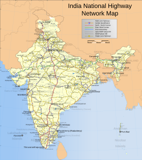
Roads are an important mode of transport in India. India has a network of over 6,215,797 kilometres (3,862,317 mi) of roads as of 31 March 2020. This is the second-largest road network in the world, after the United States with 6,853,024 kilometres (4,258,272 mi). At of roads per square kilometre of land, the quantitative density of India's road network is equal to that of Hong Kong, and substantially higher than the United States, China, Brazil and Russia. Adjusted for its large population, India has approximately 5.13 kilometres (3.19 mi) of roads per 1,000 people, which is much lower than United States 20.5 kilometres (12.7 mi) but higher than that of China 3.6 kilometres (2.2 mi). India's road network carries over 71 percent of its freight and about 85 percent of passenger traffic.

Road transport is an element of the Australian transport network, and contributes to the Australian economy. Australia relies heavily on road transport due to Australia's large area and low population density in considerable parts of the country.
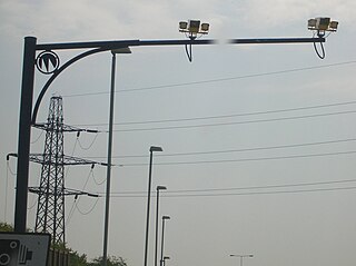
Road speed limit enforcement in the United Kingdom is the action taken by appropriately empowered authorities to attempt to persuade road vehicle users to comply with the speed limits in force on the UK's roads. Methods used include those for detection and prosecution of contraventions such as roadside fixed speed cameras, average speed cameras, and police-operated LIDAR speed guns or older radar speed guns. Vehicle activated signs and Community Speed Watch schemes are used to encourage compliance. Some classes of vehicles are fitted with speed limiters and intelligent speed adaptation is being trialled in some places on a voluntary basis.
William Rees Jeffreys was a British cyclist and early campaigner for road improvements who became a key figure in the early 20th-century development of the UK highway system. As honorary secretary and later chairman of the Roads Improvement Association and the first secretary of the Road Board, he was an early advocate of a ring road around London, and helped instigate the British road numbering system. In 1937 Jeffreys was described by former UK Prime Minister David Lloyd George as "the greatest authority on roads in the United Kingdom and one of the greatest in the whole world."
The Roads Improvement Association, established in 1882, was a British organisation which campaigned for better roads in the late 19th century and first half of the 20th century. Founded by cycling organisations ten years before the first motor cars arrived on the roads, it became predominantly a motoring body before World War I.
