Makupa Causeway

Last updated
Makupa Causeway
Makupa causeway.jpg
Coordinates 4°01′59″S39°39′02″E / 4.033122°S 39.650464°E / -4.033122; 39.650464 Coordinates: 4°01′59″S39°39′02″E / 4.033122°S 39.650464°E / -4.033122; 39.650464
Carries A109 trunk road,
Uganda Railway
Characteristics
Total length1.5 miles (2.4 km)

The Makupa Causeway (Swahili pronunciation:  [maˈkupa] ) is a causeway linking Mombasa island to the Kenyan mainland. The road runs for approximately one and a half miles between the Magongo Circus and Makupa Circus. The causeway dissects Tudor Creek to the east and Port Reitz Creek to the west. [1]

Causeway Route raised up on an embankment

A causeway is a track, road or railway on top of an embankment across "a low, or wet place, or piece of water". It can be constructed of earth, masonry, wood, or concrete. One of the earliest known wooden causeways is the Sweet Track in the Somerset Levels, England, that dates from the Neolithic age. Timber causeways may also be described as both boardwalks and bridges.

Mombasa City in Mombasa County, Kenya

Mombasa is a coastal city of Kenya along the Indian Ocean. It is the country's oldest and second-largest city, with an estimated population of about 1.5 million people in 2017. Its metropolitan region is the second largest in the country and has a population of approximately 3 million people. Administratively, Mombasa is the county seat of Mombasa County.

Magongo, Kenya Place in Mombasa County, Kenya

Magongo is a town in Mombasa County, Kenya. It is an outlying township 10 minutes northwest of Mombasa Island, situated on the Nairobi road. This fringe community lacks any effective electricity, water or sewer systems, with a general lack of infrastructure. Poverty, lack of sanitation, and unemployment continue to be the greatest issues for the Mikindani Township, which have ensured low health and safety standards for its residents. Poor, lower class housing is widespread, ranging from simple stone, two-storey structures to mud and earth homes fitted with corrugated iron roofs.

Contents

The causeway is one of three road links between the island and the Kenyan mainland the other two being the Nyali Bridge and the Kipevu Causeway.

Nyali Bridge

The Nyali Bridge is a concrete girder bridge connecting the city of Mombasa on Mombasa Island to the mainland of Kenya. The bridge crosses Tudor Creek to the north-east of the island. The bridge is one of three road links out of Mombasa. The Likoni Ferry provides a third transport link to the island, and is situated at the southern tip. The mainland approach to the bridge serves as a police checkpoint in both directions.

Function

The causeway is a dual-purpose transport corridor that carries a trunk road (serving the main A109 Mombasa-Nairobi road route) and the Uganda Railway. [2] The road is split into a two-level route (the south-bound carriageway is elevated on an embankment) and traffic is restricted to fifty miles per hour. The road serves few businesses except a large waste disposal site in the Kipevu district. In 2008, the area was the site of a considerable toxic waste leak. [3]

Transport corridor

A transport corridor is a generally linear area that is defined by one or more modes of transportation like highways, railroads or public transit which share a common course. Development often occurs around transportation corridors because they carry so many people, creating linear agglomerations like the Las Vegas Strip or the linear form of many neighborhood retail areas.

Trunk road type of major road, usually connecting major settlements

A trunk road, trunk highway, or strategic road is a major road, usually connecting two or more cities, ports, airports and other places, which is the recommended route for long-distance and freight traffic. Many trunk roads have segregated lanes in a dual carriageway, or are of motorway standard.

Nairobi City in Nairobi County, Kenya

Nairobi is the capital and the largest city of Kenya. The name comes from the Maasai phrase Enkare Nairobi, which translates to "cool water", a reference to the Nairobi River which flows through the city. The city proper had a population of 3,138,369 in the 2009 census, while the metropolitan area has a population of 6,547,547. The city is popularly referred to as the Green City in the Sun.

History

Built in 1929 by the Colonial British Government, the causeway replaced the Britannia Bridge which had been completed in 1899. In addition to the rail crossing, the causeway incorporated a road crossing. It was originally called the Macupa Causeway. It spans approximately 1200ft (365m).

Checkpoint

The south end of the causeway is the site of an armed police checkpoint. This is primarily for immigration purposes, but also functions as a traffic policing location.

Immigration Movement of people into another country or region to which they are not native

Immigration is the international movement of people into a destination country of which they are not natives or where they do not possess citizenship in order to settle or reside there, especially as permanent residents or naturalized citizens, or to take up employment as a migrant worker or temporarily as a foreign worker.

Traffic police

Traffic police or traffic officers, often referred to colloquially as traffic cops, are police officers who direct traffic or serve in a traffic or roads policing unit enforcing rules of the road. Traffic police include officers who patrol major roads and also police who address traffic infractions on other roads. It has been noted that:

...traffic police, who are regarded as peripheral to most police forces, participate in both authoritative intervention and symbolic justice. Perhaps alone of all the assignments, traffic police are full-service police. They are different from the rest, however, because their work is limited to a particular venue — namely, public thoroughfares — and to particular people — namely, those who operate motor vehicles. But in terms of work, traffic police are detectives as well as patrol officers.

Related Research Articles

Transport in Kenya

Transport in Kenya refers to the transportation structure in Kenya. The country has an extensive network of paved and unpaved roads.

New Jersey Route 52 highway in New Jersey

Route 52 is a state highway in the southern part of the U.S. state of New Jersey. The highway runs 2.74 mi (4.41 km) from 9th Street in Ocean City, Cape May County north to U.S. Route 9 in Somers Point, Atlantic County. It is composed mostly of a series of four-lane divided bridges over Great Egg Harbor Bay from Ocean City to Somers Point known as the Howard S. Stainton Memorial Causeway, also known as the Ninth Street Bridge. The remainder of the route is a surface road called MacArthur Boulevard that runs from the causeway to U.S. Route 9. This section of the route formerly included the Somers Point Circle, now a traffic light, where Route 52 intersects County Route 559 and County Route 585.

Holy Island, Anglesey island next to the Isle of Anglesey, Wales

Holy Island is an island on the western side of the larger Isle of Anglesey, Wales, from which it is separated by a narrow, winding channel. It is called "Holy" because of the high concentration of standing stones, burial chambers, and other religious sites on the small island. The alternative English name of the island is Holyhead Island. According to the 2011 UK Census, the population was 13,659, of which 11,431 (84%) lived in the largest town, Holyhead.

Mombasa Island island

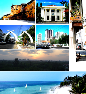
Mombasa Island is a 5 by 3 km coral outcrop located on Kenya's coast on the Indian Ocean, which is connected to the mainland by a causeway. Part of the city of Mombasa is located on the island, including the Old Town.

Wantagh State Parkway highway in New York

The Wantagh State Parkway is a 13.33-mile (21 km) long state parkway on Long Island, New York, in the United States. It links the Ocean Parkway in Jones Beach State Park with the Northern State Parkway in Westbury. The parkway is located approximately 30 miles (48 km) east of Manhattan and 14 miles (23 km) east of the Nassau–Queens border. Construction began in 1927 on this, one of the earliest of the Long Island parkways, with the initial 5-mile (8 km) segment opening two years later as the Jones Beach Causeway, connecting Merrick Road in Wantagh to newly opened Jones Beach State Park. The parkway is inventoried by the New York State Department of Transportation (NYSDOT) as New York State Route 908T (NY 908T), an unsigned reference route.

Borden-Carleton Town in Prince Edward Island, Canada

Borden-Carleton is a Canadian town located in Prince County, Prince Edward Island.

Moi International Airport airport

Moi International Airport, is the international airport of Mombasa, the second-biggest city in Kenya. It is located in Mombasa County, in a township called Port Reitz and features regional as well as intercontinental flights.

Kilindini Harbour is a large, natural deep-water inlet extending inland from Mombasa, Kenya. It is 25-30 fathoms at its deepest center, although the controlling depth is the outer channel in the port approaches with a dredged depth of 17.5 metres (57 ft). It serves as the harbour for Mombasa, with a hinterland extending to Uganda. Kilindini Harbour is the main part of the Port of Mombasa, the only international seaport in Kenya and the biggest port in east Africa. It is managed by the Kenya Ports Authority (KPA). Apart from cargo handling, Mombasa is frequented by Cruise ships.

A fixed link or fixed crossing is a persistent, unbroken road or rail connection across water that uses some combination of bridges, tunnels, and causeways and does not involve intermittent connections such as drawbridges or ferries. A bridge–tunnel combination is commonly used for major fixed links.

National Cycle Route 1 route of the National Cycle Network in the UK

National Cycle Route 1 is a route of the National Cycle Network, running from Dover to Shetland. The 1,695-mile-long (2,728 km) cycle-path is located in the United Kingdom.

Likoni Ferry

The Likoni Ferry is a boat service across the Kilindini Harbour, serving both the island city of Mombasa and the Kenyan mainland town of Likoni. Two - four double-ended ferries alternate across the harbour, carrying both road and foot traffic. The ferries are operated by the Kenya Ferry Services (KFS), and is the only remaining ferry service by KFS. The Likoni ferry started operating in 1937. Passenger services are free while vehicles, tuktuks and motorcycles have to pay a ferry toll.

Tudor Creek is one of two main water bodies separating Mombasa Island from the Kenyan mainland.

Jomo Kenyatta Avenue street in Mombasa, Kenya

Jomo Kenyatta Avenue is a major road in Mombasa, Kenya. The majority of the road is a six-lane dual carriageway, separated by a concrete reservation of approximately 3 metres (9.8 ft) in width.

The Makupa Circus is a primary road junction in Mombasa, Kenya. The roundabout is situated in the Makupa area of the island.

Mackinnon Road is a town in Kwale County, Kenya, with a population of around 8000 in 1999, located between Mombasa and Voi. Just a few kilometers from Taru.

Chaani is a suburb of Mombasa, Kenya. It is bordered by Port Reitz to the west, Changamwe to the north and Kilindini Harbour to the south. It is linked to Mombasa Island by the Kipevu Causeway.

Dongo Kundu Bypass Highway, also Mombasa Southern Bypass Highway , is a road under construction in Kenya. When completed, it will connect Mombasa Mainland West to Mombasa Mainland South, without entering Mombasa Island.

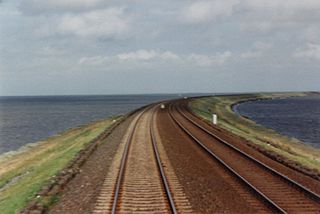
The Mombasa–Nairobi Standard Gauge Railway is a standard-gauge railway (SGR) in Kenya that connects the large Indian Ocean city of Mombasa with Nairobi, the country's capital and largest city. This SGR runs parallel to the defunct narrow-gauge Uganda Railway that was completed in 1901 under British colonial rule. The East African Railway Master Plan provides for the Mombasa–Nairobi SGR to link with other SGRs being built in the East African Community.

References

  1. A. W. Muohia, J. M. Onyarib: "Heavy metals in sediments from Makupa and Port–Reitz Creek systems: Kenyan Coast" (2002)
  2. East African Railways Archived 2005-05-07 at the Wayback Machine
  3. BBC NEWS | World | Africa | Kenyans ill in 'toxic waste' leak

Coordinates: 4°1′59.24″S39°39′01.67″E / 4.0331222°S 39.6504639°E / -4.0331222; 39.6504639

Geographic coordinate system Coordinate system

A geographic coordinate system is a coordinate system that enables every location on Earth to be specified by a set of numbers, letters or symbols. The coordinates are often chosen such that one of the numbers represents a vertical position and two or three of the numbers represent a horizontal position; alternatively, a geographic position may be expressed in a combined three-dimensional Cartesian vector. A common choice of coordinates is latitude, longitude and elevation. To specify a location on a plane requires a map projection.