Transport corridor

Last updated
The M1 Motorway was built alongside the West Coast Main Line in Northamptonshire. WCML and M1.jpg
The M1 Motorway was built alongside the West Coast Main Line in Northamptonshire.

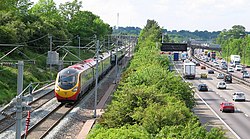
A transport corridor is a generally linear area that is defined by one or more modes of transportation crossing the limits of more than one city or county like highways, railroads or public transit which share a common destination. Development often occurs around transportation corridors because they carry so many people, creating linear agglomerations like the Las Vegas Strip or the linear form of many neighborhood retail areas.

Contents

A 2019 review and meta-analysis of research into transport corridors found that they improved economic welfare, but had adverse environmental impacts. [1]

Examples

SE Asia

Sourced from

See also

Related Research Articles

The vast majority of passenger travel in the United States occurs by automobile for shorter distances and airplane or railroad for longer distances. Most cargo in the U.S. is transported by, in descending order, railroad, truck, pipeline, or boat; air shipping is typically used only for perishables and premium express shipments. Transportation is the largest source of greenhouse gas emissions in the United States.

<span class="mw-page-title-main">Inter-city rail</span> Inter-city passenger rail transport

Inter-city rail services are express passenger train services that run services that connect cities over longer distances than commuter or regional trains. They include rail services that are neither short-distance commuter rail trains within one city area nor slow regional rail trains stopping at all stations and covering local journeys only. An inter-city train is typically an express train with limited stops and comfortable carriages to serve long-distance travel.

<span class="mw-page-title-main">NJ Transit</span> Public transportation system

New Jersey Transit Corporation, branded as NJ Transit or NJTransit and often shortened to NJT, is a state-owned public transportation system that serves the U.S. state of New Jersey and portions of the state of New York and Pennsylvania. It operates bus, light rail, and commuter rail services throughout the state, connecting to major commercial and employment centers both within the state and in its two adjacent major cities, New York City and Philadelphia. In 2022, the system had a ridership of 175,960,600.

<span class="mw-page-title-main">Trans-European Transport Network</span> European Union infrastructure corridors and agreements

The Trans-European Transport Network (TEN-T) is a planned network of roads, railways, airports and water infrastructure in the European Union. The TEN-T network is part of a wider system of Trans-European Networks (TENs), including a telecommunications network (eTEN) and a proposed energy network. The European Commission adopted the first action plans on trans-European networks in 1990.

<span class="mw-page-title-main">Eurasian Land Bridge</span> Rail route between East Asia and Europe

The Eurasian Land Bridge, sometimes called the New Silk Road, is the rail transport route for moving freight and passengers overland between Pacific seaports in the Russian Far East and China and seaports in Europe. The route, a transcontinental railroad and rail land bridge, currently comprises the Trans-Siberian Railway, which runs through Russia and is sometimes called the Northern East-West Corridor, and the New Eurasian Land Bridge or Second Eurasian Continental Bridge, running through China and Kazakhstan. As of November 2007, about one percent of the $600 billion in goods shipped from Asia to Europe each year were delivered by inland transport routes.

<span class="mw-page-title-main">Rail trail</span> Railroad bed converted to a recreational trail

A rail trail is a shared-use path on railway right of way. Rail trails are typically constructed after a railway has been abandoned and the track has been removed but may also share the right of way with active railways, light rail, or streetcars, or with disused track. As shared-use paths, rail trails are primarily for non-motorized traffic including pedestrians, bicycles, horseback riders, skaters, and cross-country skiers, although snowmobiles and ATVs may be allowed. The characteristics of abandoned railways—gentle grades, well-engineered rights of way and structures, and passage through historical areas—lend themselves to rail trails and account for their popularity. Many rail trails are long-distance trails, while some shorter rail trails are known as greenways or linear parks.

<span class="mw-page-title-main">Southeast High Speed Rail Corridor</span> Proposed passenger rail project in the United States

The Southeast Corridor (SEC) is a proposed passenger rail transportation project in the Mid-Atlantic and Southeastern United States to extend high-speed passenger rail services from the current southern terminus of the Northeast Corridor in Washington, D.C.. Routes would extend south via Richmond and Petersburg, Virginia, with a spur to Norfolk in Virginia's Hampton Roads region; the mainline would continue south to Raleigh, Durham, Greensboro, and Charlotte, North Carolina. Since the corridor was first established in 1992, the U.S. Department of Transportation (USDOT) has extended it further to Atlanta, Georgia and Macon, Georgia; Greenville, South Carolina; Columbia, South Carolina; Jacksonville, Florida; and Birmingham, Alabama.

<span class="mw-page-title-main">Federal Railroad Administration</span> Agency of the U.S. Department of Transportation

The Federal Railroad Administration (FRA) is an agency in the United States Department of Transportation (DOT). The agency was created by the Department of Transportation Act of 1966. The purpose of the FRA is to promulgate and enforce rail safety regulations, administer railroad assistance programs, conduct research and development in support of improved railroad safety and national rail transportation policy, provide for the rehabilitation of Northeast Corridor rail passenger service, and consolidate government support of rail transportation activities.

<span class="mw-page-title-main">Intermodal Surface Transportation Efficiency Act</span> US federal highway legislation

The Intermodal Surface Transportation Efficiency Act of 1991 is a United States federal law that posed a major change to transportation planning and policy, as the first U.S. federal legislation on the subject in the post-Interstate Highway System era.

<span class="mw-page-title-main">Rail transportation in the United States</span>

Rail transportation in the United States consists primarily of freight shipments along a well integrated network of standard gauge private freight railroads that also extend into Canada and Mexico. The United States has the largest rail transport network size of any country in the world, at a total of approximately 160,000 miles (260,000 km).

<span class="mw-page-title-main">Greenway (landscape)</span> Shared-use path or linear park with vegetation

A greenway is usually a shared-use path along a strip of undeveloped land, in an urban or rural area, set aside for recreational use or environmental protection. Greenways are frequently created out of disused railways, canal towpaths, utility company rights of way, or derelict industrial land. Greenways can also be linear parks, and can serve as wildlife corridors. The path's surface may be paved and often serves multiple users: walkers, runners, bicyclists, skaters and hikers. A characteristic of greenways, as defined by the European Greenways Association, is "ease of passage": that is that they have "either low or zero gradient", so that they can be used by all "types of users, including mobility impaired people".

<span class="mw-page-title-main">High-speed rail in the United States</span> Overview of the high-speed rail system in the United States of America

Plans for high-speed rail in the United States date back to the High-Speed Ground Transportation Act of 1965. Various state and federal proposals have followed. Despite being one of the world's first countries to get high-speed trains, it failed to spread. Definitions of what constitutes high-speed rail vary, including a range of speeds over 110 mph (180 km/h) and dedicated rail lines. Inter-city rail with top speeds between 90 and 125 mph is sometimes referred to in the United States as higher-speed rail.

<span class="mw-page-title-main">New York high-speed rail</span> Overview of proposals for high-speed rail in the US state of New York

High-speed rail in New York has been a topic that is consistently discussed among legislators, political leaders and in particular, several past governors since the 1990s, but thus far little progress has been made. In his campaign speeches prior to his defeat by Governor George Pataki in 1994, Mario Cuomo promised to bring high speed (maglev) rail up the Hudson Valley and along the Catskill Mountains route. It was not a priority for the subsequent administration.

<span class="mw-page-title-main">High-speed rail in Canada</span> Overview of the high-speed rail system in Canada

Several plans have been proposed for high-speed rail in Canada, the only G7 country that does not have any high-speed rail. In the press and popular discussion, there have been two routes frequently proposed as suitable for a high-speed rail corridor: Edmonton to Calgary via Red Deer and Windsor to Quebec City via London, Kitchener-Waterloo, Toronto, Ottawa and Montreal.

<span class="mw-page-title-main">Transportation in California</span> Overview of the transport in the State of California

California's transportation system is complex and dynamic. Although known for its car culture and extensive network of freeways and roads, the state also has a vast array of rail, sea, and air transport. Several subway, light rail, and commuter rail networks are found in many of the state's largest population centers. In addition, with the state's location on the West Coast of the United States, several important ports in California handle freight shipments from the Pacific Rim and beyond. A number of airports are also spread out across the state, ranging from small general aviation airports to large international hubs like Los Angeles International Airport and San Francisco International Airport.

<span class="mw-page-title-main">Northeast megalopolis</span> Megaregion of the U.S.

The Northeast megalopolis—also known as the Northeast Corridor, Acela Corridor, Boston–Washington corridor, BosWash, or BosNYWash—is the world's largest megalopolis by economic output and the second-most populous megalopolis in the United States with about 50 million residents as of 2022.

<span class="mw-page-title-main">Delaware and Lehigh National Heritage Corridor</span> United States National Heritage Area in Pennsylvania

The Delaware & Lehigh Canal National and State Heritage Corridor (D&L) is a 165-mile (266 km) National Heritage Area in eastern Pennsylvania in the United States. It stretches from north to south, across five counties and over one hundred municipalities. It follows the historic routes of the Lehigh and Susquehanna Railroad, Lehigh Valley Railroad, the Lehigh Navigation, Lehigh Canal, and the Delaware Canal, from Bristol northeast of Philadelphia to Wilkes-Barre in the northeastern part of the state.

<span class="mw-page-title-main">Public transportation in the United States</span> Publicly financed transit services in the country

The United States is serviced by a wide array of public transportation, including various forms of bus, rail, ferry, and sometimes, airline services. Most established public transit systems are located in central, urban areas where there is enough density and public demand to require public transportation. In more auto-centric suburban localities, public transit is normally, but not always, less frequent and less common. Most public transit services in the United States are either national, regional/commuter, or local, depending on the type of service. Sometimes "public transportation" in the United States is an umbrella term used synonymously with "alternative transportation", meaning any form of mobility that excludes driving alone by automobile. This can sometimes include carpooling, vanpooling, on-demand mobility, infrastructure that is oriented toward bicycles, and paratransit service. There is public transit service in most US cities.

<span class="mw-page-title-main">Megaregions of the United States</span>

The megaregions of the United States are generally understood to be regions in the U.S. that contain two or more roughly adjacent urban metropolitan areas that, through commonality of systems—of transport, economy, resources, and ecologies—experience blurred boundaries between the urban centers, such that perceiving and acting as if they are a continuous urban area is, for the purposes of policy coordination, of practical value. The antecedent term, with which "megaregions" is synonymous, is megalopolis, which was coined in relation to the Boston through Washington, D.C., corridor in the Atlantic Northeast, by Jean Gottmann in the mid-twentieth century. America 2050, a project of the Regional Plan Association, lists 11 megaregions encompassing urban regions in the United States, Canada, and Mexico. As of December 2000, these clustered networks of American cities contained an estimated total population exceeding 280 million people.

<span class="mw-page-title-main">Higher-speed rail</span> Type of railway with speeds approaching but less than that of true high speed rail

Higher-speed rail (HrSR), also known as high-performance rail, higher-performance rail, semi-high-speed rail or almost-high-speed rail, is the jargon used to describe inter-city passenger rail services that have top speeds of more than conventional rail but are not high enough to be called high-speed rail services. The term is also used by planners to identify the incremental rail improvements to increase train speeds and reduce travel time as alternatives to larger efforts to create or expand the high-speed rail networks.

References

  1. Roberts, Mark; Melecky, Martin; Bougna, Théophile; Xu, Yan (Sarah) (2019). "Transport corridors and their wider economic benefits: A quantitative review of the literature". Journal of Regional Science. 60 (2): 207–248. doi:10.1111/jors.12467. hdl: 10084/138956 . ISSN   1467-9787. S2CID   204410119.