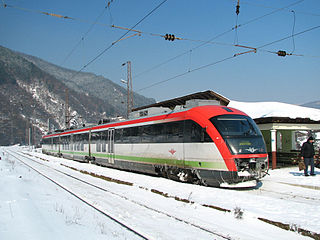
This article considers transport in Armenia.
Transport in Bulgaria is dominated by road transport. As of 2024, the country had 879 kilometers of highways and another 117 km under construction. The total length of the network is almost 40,000 km, divided nearly in half between the national and the municipal road network. In addition, there are 57,000 km of streets. Buses play a significant role in long-distance public transport, coaches are operated by private companies. The capital Sofia has three major national bus terminals, the Central, the Western and the Southern Terminals.
The Trans-Asian Railway(TAR) is a project to create an integrated freight railway network across Europe and Asia. The project is of the United Nations Economic and Social Commission for Asia and the Pacific (UNESCAP).

The Trans-European Transport Network (TEN-T) is a planned network of roads, railways, airports and water infrastructure in the European Union. The TEN-T network is part of a wider system of Trans-European Networks (TENs), including a telecommunications network (eTEN) and a proposed energy network. The European Commission adopted the first action plans on trans-European networks in 1990.

The Eurasian Land Bridge, sometimes called the New Silk Road, is the rail transport route for moving freight and passengers overland between Pacific seaports in the Russian Far East and China and seaports in Europe. The route, a transcontinental railroad and rail land bridge, currently comprises the Trans-Siberian Railway, which runs through Russia and is sometimes called the Northern East-West Corridor, and the New Eurasian Land Bridge or Second Eurasian Continental Bridge, running through China and Kazakhstan. As of November 2007, about one percent of the $600 billion in goods shipped from Asia to Europe each year were delivered by inland transport routes.

A transport corridor is a generally linear area that is defined by one or more modes of transportation crossing the limits of more than one city or county like highways, railroads or public transit which share a common destination. Development often occurs around transportation corridors because they carry so many people, creating linear agglomerations like the Las Vegas Strip or the linear form of many neighborhood retail areas.
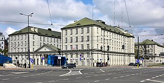
PKP Polskie Linie Kolejowe S.A. is the Polish railway infrastructure manager, responsible for maintenance of rail tracks, conducting trains across the country, scheduling train timetables, and management of railway land.

European route E73 forms part of the United Nations International E-road network, connecting Hungary and eastern Croatia to Bosnia and Herzegovina and the Adriatic Sea in the vicinity of the port of Ploče. This 679-kilometre (422 mi) route is also designated as the Pan-European Corridor Vc, a branch of the fifth Pan-European corridor. The route largely consists of two-lane roads with at-grade intersections, although in the 2000s, about a third of the route was upgraded to motorway standards. The remainder of the route is currently being upgraded in all the countries spanned. The longest part of this corridor goes through Bosnia and Herzegovina and is widely touted as a road instrumental to the development of the country. As such, and given its geographical location, the road has occasionally been dubbed as the kičma Bosne. The road also serves as the shortest connection of the eastern and southern parts of Croatia.
TRACECA is an international transport programme involving the European Union and 12 member states of the Eastern European, Caucasus, and Central Asian region. The programme aim is to strengthen economic relations, trade, and transport in the regions of the Black Sea basin, South Caucasus, and Central Asia. It has a permanent Secretariat, originally financed by the European Commission, in Baku, Azerbaijan, and a regional office in Odesa, Ukraine. Since 2009, the organization has been entirely financed by member countries.
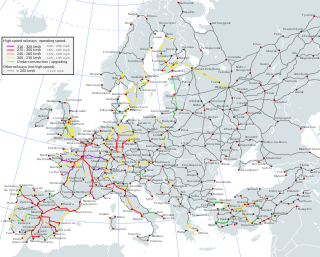
The Trans-European high-speed rail network (TEN-R), together with the Trans-European conventional rail network, make up the Trans-European Rail network, which in turn is one of a number of the European Union's Trans-European transport networks (TEN-T). It was defined by the Council Directive 96/48/EC of 23 July 1996.
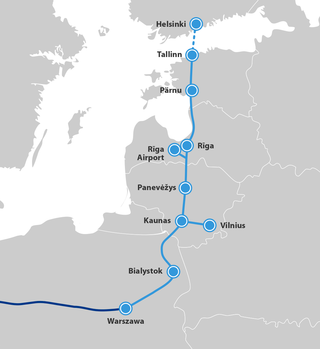
Rail Baltica is an under-construction rail infrastructure project that is intended to integrate the Baltic states in the European rail network. Its purpose is to provide passenger and freight service between participating countries and improve rail connections between Central and Northern Europe, specifically the area southeast of the Baltic Sea. It is also intended as a catalyst for building the economic corridor in Northeastern Europe. The project envisages a continuous rail link from Tallinn (Estonia) to Warsaw (Poland), consisting of links via Riga (Latvia), Kaunas, and Vilnius (Lithuania). Its total length in the Baltic States is 870 kilometres (540 mi), with 213 kilometres (132 mi) in Estonia, 265 kilometres (165 mi) in Latvia, and 392 kilometres (244 mi) in Lithuania. Rail Baltica is one of the priority projects of the European Union (EU). It is part of the North Sea–Baltic Corridor of the Trans-European Transport Networks (TEN-T).
The Trans-European conventional rail network, together with the Trans-European high-speed rail network, make up the Trans-European Rail network, which in turn is one of a number of the European Union's Trans-European transport networks (TEN-T). It was defined by the Council Directive 2001/16/EC of 19 March 2001.
European route E 71 is a north-south Class-A intermediate European road route. It begins in Košice, Slovakia, passes through Budapest in Hungary, Zagreb in Croatia, and ends at Split in Croatia on the Adriatic Sea coast. The total length of the route is 1,016 km (631 mi). The E71 mostly consists of motorways, but considerable sections are either expressways or two-lane roads with at-grade intersections. Nearly all motorway sections of the E71 are tolled, using various toll collection systems including Electronic toll collection (ETC) and ticket systems. Individual segments of the E71 route are shared with several other European routes. The E71 section between Karlovac and Split is inconsistently physically signposted or marked on maps and route planning software. The E71 route has gradually been upgraded from a regular two-lane road to motorway standards since the 1970s; upgrades are still being carried out in some areas.

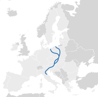
The Berlin–Palermo railway axis is project No. 1 of the Trans-European high-speed rail network (TEN-R), which involves the creation of a 2,200-kilometre-long (1,400 mi) high-speed rail line between Berlin and Palermo. It is designated as one of the main transport links connecting Central and Southern Europe, tracking through Germany, Austria and Italy.

Azerbaijan Railways is the national state-owned rail transport operator in the Republic of Azerbaijan. The 2,918 km (1,813 mi), 1,520 mm gauge network is electrified at 3 kV (3,000 V) DC. The headquarters of the Azerbaijan Railways is in the capital Baku.
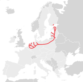
The Baltic–Adriatic Corridor or Baltic–Adriatic Axis is a European initiative to create a high capacity north–south railway and road corridor connecting Gdańsk on the Baltic Sea with Bologna and the Adriatic. The line traverses Poland, the Czech Republic, Slovakia, Austria and Italy, connecting heavily industrialized areas such as Warsaw and the Upper Silesian Coal Basin, Vienna and south-east Austria, and Northern Italy. It developed from the Trans-European Transport Network (TEN-T) project No. 23 of a Gdańsk-Vienna railway axis set up in 2003. Carrying 24 million tons of freight per year, the Baltic–Adriatic Corridor is considered among the most important trans-Alpine lines in Europe.

The Highways in Albania are the central state and main transport network in Albania. The motorways and expressways are both part of the national road network. The motorways are primary roads with a speed limit of 110 kilometres per hour (68 mph). They have white on green road signs such as in Italy and other countries nearby. The expressways are the secondary roads, also dual carriageways, but without an emergency lane. They have a speed limit of 90 kilometres per hour (56 mph). They have white-on-blue road signs.

The Scandinavian–Mediterranean Corridor, shortened as Scan–Med Corridor and known also as Helsinki–Valletta Corridor, is the 5th of 10 priority axes of the Trans-European Transport Network.
The North Sea–Baltic Corridor is the number 2 of the ten priority axes of the Trans-European Transport Network (TEN-T).

The SH4 highway is a national highway in Albania spanning 223.29 kilometres across the counties of Durrës, Fier, Gjirokastër and Tirana. As it connects the country's second largest city Durrës to Greece, the highway represents a significant north–south transportation corridor in Albania and an essential part of the Adriatic–Ionian motorway and Pan-European Corridor VIII.
