Related Research Articles

Downieville is a census-designated place in and the county seat of Sierra County, California, United States. Downieville is on the North Fork of the Yuba River, at an elevation of 2,966 feet (904 m). The 2010 United States census reported Downieville's population was 282.
The Gold Country is a historic region in the northern portion of the U.S. state of California, that is primarily on the western slope of the Sierra Nevada. It is famed for the mineral deposits and gold mines that attracted waves of immigrants, known as the 49ers, during the 1849 California Gold Rush.

State Route 49 is a north–south state highway in the U.S. state of California that passes through many historic mining communities of the 1849 California gold rush. Highway 49 is numbered after the "49ers", the waves of immigrants who swept into the area looking for gold, and it is known as the Golden Chain Highway. This roadway begins at Oakhurst, Madera County, in the Sierra Nevada, where it diverges from State Route 41. It continues in a generally northwest direction, weaving through the communities of Goldside and Ahwahnee, before crossing into Mariposa County. State Route 49 then continues northward through the counties of Tuolumne, Calaveras, Amador, El Dorado, Placer, Nevada, Yuba, Sierra, and Plumas, where it reaches its northern terminus at State Route 70, in Vinton.

South Yuba River State Park is located along the South Fork of the Yuba River in the Sierra Nevada, within Nevada County, in Northern California.

Washington is a census-designated place located in Nevada County, California. Washington is located on the banks of the South Fork of The Yuba River and has a population of approximately two hundred people. There is a hotel/bar and restaurant, grocery store, a one-room schoolhouse that has educated students continuously for one hundred years, and two trailer park campgrounds. The elevation is 2,612 feet (796 m). The population was 185 at the 2010 census.

The Yuba River is a tributary of the Feather River in the Sierra Nevada and eastern Sacramento Valley, in the U.S. state of California. The main stem of the river is about 40 miles (64 km) long, and its headwaters are split into three major forks. The Yuba River proper is formed at the confluence of the North Yuba and Middle Yuba Rivers, with the South Yuba joining a short distance downstream. Measured to the head of the North Yuba River, the Yuba River is just over 100 miles (160 km) long.

French Corral is an unincorporated community approximately five miles west of California State Highway 49 in Nevada County, California.

The Bear River is a tributary of the Feather River in the Sierra Nevada, winding through four California counties: Yuba, Sutter, Placer, and Nevada. About 73 miles (117 km) long, the river flows generally southwest through the Sierra then west through the Central Valley, draining a narrow, rugged watershed of 295 square miles (760 km2).

Oak Valley is an unincorporated community in Yuba County, California. It is located 5.5 miles (8.9 km) south-southeast of Strawberry Valley, at an elevation of 3012 feet.

Timbuctoo is an unincorporated community in Yuba County, California. It lies northwest of Smartsville, at an elevation of 397 feet.

Bullards Bar is a former gold mining settlement in Yuba County, California.
Condemned Bar is a former settlement, in Yuba County, California.

The San Juan Ridge is a geographic feature extending approximately 24 miles (39 km) east-northeast between the South and Middle Yuba Rivers in the foothills of the northern Sierra Nevada. The elevation is approximately 790 m (2,600 ft) above sea level.
English Bar is a former mining settlement and stage stop in Yuba County, California.
Landers Bar is a former mining settlement of the California Gold Rush, in Yuba County, California.
Cordua Bar is a former mining town of the California Gold Rush, located in Yuba County, California.
Cape Horn Bar is a former settlement and mining camp of the California Gold Rush, in Yuba County, California.
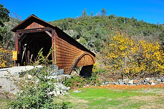
Bridgeport is a former settlement on the Yuba River in Nevada County, California, 2 mi (3.2 km) from the town of French Corral. Its elevation is 567 ft (173 m) above sea level.
Brass Wire Bar is a former settlement in Nevada County, California. Brass Wire Bar is located on the South Yuba River, across from Washington. It was a mining camp; Chinese miners worked the site in 1880. About $50,000 dollars worth of gold was found there.
The Independence Trail is located approximately 7 miles from downtown Nevada City within the South Yuba River State Park in the Sierra Nevada foothills within Nevada County, in Northern California. The trail is the former Excelsior Ditch, which was found and repaired by John Olmsted and a large group of local volunteers. It is notable for being the first ADA approved wheelchair nature trail. It topped the list of "favorite trails for 2013" in The Sacramento Bee newspaper.
References
- 1 2 Durham, David L. (1998). California's Geographic Names: A Gazetteer of Historic and Modern Names of the State. Clovis, Calif.: Word Dancer Press. p. 557. ISBN 1-884995-14-4.
Municipalities and communities of Yuba County, California, United States | ||
|---|---|---|
| Cities |  | |
| CDPs | ||
| Unincorporated communities | ||
| Ghost towns | ||
| Footnotes | ‡This populated place also has portions in an adjacent county or counties | |
| This Yuba County, California-related article is a stub. You can help Wikipedia by expanding it. |