Malkot

Last updated

Malkot is a village of Abbottabad District in Khyber-Pakhtunkhwa province of Pakistan. Until the local government reforms of 2000 it was a Union Councils of the district. [1]

Contents

History

Malkot is a remote village of Hazara in Khyber-Pakhtunkhwa. The Abbasi tribe is the major tribe here. Malkot is on the border of Punjab, union council pluk

Development

Geographically, Malkot almost is in the center of union council and the nearest village to Punjab. People can reach Ayubia, Khera Gali Murree, Dunga Gali in 20 to 40 minutes. Malkot produced many politicians and also many other professionals like judges, doctors, engineers and businessmen.

Sardar Mehtab Khan was Chief Minister of Khyber-Pakhtunkhwa from March 1997 to October 1999 during the government of PML(N) and became governor of KPK from 2014

In comparison to neighbouring villages such as Riala, Palak, Kalaban, Khushikot, Arwar and Longal, Malkot is well-developed.

Mehtab Ahmed Khan became the 22nd chief minister of Khyber-Pakhtunkhwa on 21 February 1997.

Dividing Abbottabad district to sub Tahseels was one of the major demand community at large was dreaming for but was overturned.


Van services are available for Rawalpindi and Islamabad. Travelling to Islamabad by road from Malkot takes two hours.

The Lower Malkot area has a Ptcl exchange. Additionally, all Pakistani mobile phone companies service are available at Malkot.

Location

Malkot is located in the south-eastern part of Khyber-Pakhtunkhwa and forms part of the border with Punjab province (it borders the Murree Tehsil of Rawalpindi District). Neighbouring union councils are Nathia Gali to the west.

Tribes

The main tribe of this area is the Abbasi.

Climate

Malkot is a mountainous area, with many pine, plum, orange and apple trees. Like Abbottabad District as a whole it has ideal climate conditions. Compared to the rest of the country, the summers are mild and pleasant and snow falls in winter.

Education and health

In the religious sector, Malkot is most advanced in Islamic studies with a lot of Islamic madrassas in the lower and upper village and a mosque, one of them newly reconstructed in upper Malkot.

Livelihood

Many people from this area have settled in Islamabad. Others work in the cities whilst their families still live in the villages of Malkot. There are a range of different occupations - like hotel management and running general stores, while others emigrate to earn their livelihood. Khushikot people are educated, there is a famous school in Abbottabad, the school name is Al-Ghazali Public school.

Related Research Articles

Nathia Gali Hill Station in Khyber Pakhtunkhwa, Pakistan

Nathia Gali or Nathiagali is a mountain resort town or hill station in Abbottabad District of Khyber Pakhtunkhwa, Pakistan. It is located at the center of the Galyat range, where several hill-stations are situated, closely connected to each other, and with their names mostly ending in 'Gali'. Nathiagali is known for its scenic beauty, hiking tracks and pleasant weather, which is much cooler than the rest of the Galyat due to it being at a greater altitude. It is situated 32 kilometers at one hour's drive away from both Murree and Abbottabad, lying midway between these two places. The drive time from Islamabad and Peshawar is about three and four hours, respectively, unless there is a lot of traffic.

Galyat region, or hill tract, is a narrow strip or area roughly 50–80 km north-east of Islamabad, Pakistan, extending on both sides of the Khyber Pakhtunkhwa-Punjab border, between Abbottabad and Murree. The word itself is derived from the plural of the Urdu word gali, which means an alley between two mountains on both sides of which there are valleys and it is not the highest point in the range. Many of the towns in the area have the word gali as part of their names, and are popular tourist resorts.

Murree City in Punjab, Pakistan

Murree is a mountain resort town, located in the Galyat region of the Pir Panjal Range, within the Rawalpindi District of Punjab, Pakistan. It forms the outskirts of the Islamabad-Rawalpindi metropolitan area, and is about 30 km (19 mi) northeast of Islamabad. It has average altitude of 2,291 metres (7,516 ft).

Bhurban Town in Punjab, Pakistan

Bhurban is a small town and a hill station in Punjab province, Pakistan. The resort town is named after a nearby forest. It is located approximately 11 kilometres (6.8 mi) from Murree city.

Dahamtore Union Council Union council in Khyber-Pakhtunkhwa, Pakistan

Dahamtore is situated at about 6 km towards east of Abbottabad, Hazara, Khyber Pakhtunkhwa, Pakistan and is the largest village and union council of Abbottabad. Their language is Hindko which is the traditional mother tongue of the Hazara Division but in some villages specially Nagakki village, Gojri is also mother tongue. Dhamtour village is the gate way to places like Murree, Nathiagali, Dunga Gali, Bara_Gali, Ayubia_National_Park, Miranjani, Mukeshpuri and most famous picnic spot of Abbottabad, Harnoi. The Union council is located in Abbottabad District in the Khyber-Pakhtunkhwa province of Pakistan.

Haro River

Haro is the name of a river that flows through Khyber Pakhtunkhwa and parts of Punjab. Its main valley is in Abbottabad District in the Hazara Division of Khyber Pakhtunkhwa province, northern Pakistan. The famous Khanpur Dam has been built on this river at Khanpur in the Haripur District of Hazara Division to provide drinking water to the twin cities i.e. Islamabad and Rawalpindi. The decrease in inflows of Khanpur dam from Haro River results in water shortage in the twin cities during summer season.

Seer Gharbi Union council in Khyber-Pakhtunkhwa, Pakistan

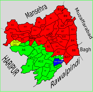
Seer Gharbi,سير غربي, is one of the 51 union councils of Abbottabad District in Khyber-Pakhtunkhwa province of Pakistan. It is located in the southeastern part of the province, bordering the Rawalpindi District of Punjab province.

Nagri Totial Union council in Khyber Pakhtunkhwa, Pakistan

Nagri Tutial is one of the 51 union councils of Abbottabad District in Khyber Pakhtunkhwa province of Pakistan.

Lora, Khyber Pakhtunkhwa Union council in Khyber Pakhtunkhwa, Pakistan

Lora is one of the 51 union councils of Abbottabad District in the Khyber Pakhtunkhwa of Pakistan. Lora Union Council takes its name from the main village of area. The local language is Hindko but Urdu is also universally understood. Tehsil Lora have 6 union concils. U.C Phallah, Lora,Seer Sharqi, Seer Gharbi, Goreeni and Nagri.

Phalla Union council takes its name from the chief village in the area. It is one of the most densely populated union councils of Abbottabad District in Khyber-Pakhtunkhwa province of Pakistan. Most of the area is hilly. These mountain are linked with the mountains of the Murree and Margalla hills of Islamabad. Village Phalla and Ghambir are thickly populated area of this Union Council.

Goreeni Union council in Khyber-Pakhtunkhwa, Pakistan

Goreeni is one of the 51 union councils of Abbottabad District in Khyber-Pakhtunkhwa province of Pakistan.

Kotli Sattian Tehsil Tehsil in Punjab, Pakistan

Kotli Sattian Sattian is a tehsil (subdivision) of Rawalpindi District in the North Punjab province of Pakistan. Its name is derived from the mountain town of Kotli and the Satti tribe. This subdivision is geographically a part of Murree and Kahuta hills. It was declared a subdivision in 1990 by breaking up 40 villages out of both subdivisions. The people of Kotli Sattian are referred to as Pahari People. The language of this region and the neighbouring areas of Azad Jammu and Kashmir and some areas of east Khyber Pakhtunkhwa is Pahari language. The people of Kotli Sattian are generally well built and of balanced height, sturdy and strong, hardworking and fair in complexion. They are proud of their ancestors pure-blood. The people of this region are inborn soldiers and belong to the martial races in the northwest of the sub-continent. They possess a distinctive place and role in Armed Forces of Pakistan.

Kuthwal Union council in Khyber-Pakhtunkhwa, Pakistan

Kuthwal is one of the 51 union councils of Abbottabad District in the Khyber-Pakhtunkhwa province of Pakistan. It is located to the north west of Abbottabad city.

Rahi is a village in the Union Council of Phallah, Abbottabad District, Khyber Pakhtunkhwa, Pakistan. It is located in the south west of the district.

Basian Place in Khyber Pakhtunkhwa, Pakistan

Basian, also known as Abbasian, is a town in Abbottabad District of Khyber Pakhtunkhwa province of Pakistan, it is located at 34°04′24″N 73°29′41″E and has an average elevation of 660 metres (2168 feet).

Darya Gali is a village and union council of Murree Tehsil in the Rawalpindi District of Punjab, Pakistan. It is located in the north of the tehsil and is bounded to the north by Khyber-Pakhtunkhwa, to the south by Ghora Gali and Murree, and to the west by Rawat.

Tret is a village and union council of Murree Tehsil in the Rawalpindi District of Punjab, Pakistan. It is located in the south of the tehsil at 33°49′60″N 73°16′60″E and is bounded to the north by Khyber Pakhtunkhwa, to the north-east by Ghora Gali, to the east by Numbal and to the south by Angoori. During the British rule, Tret housed a few army installations and a Dak Bungalow

Potha Sharif is a village and union council of Murree Tehsil in the Rawalpindi District of Punjab, Pakistan. It is located in the north-east of the tehsil at 33°57'0N 73°30'0E, and is bounded to the north by Phagwari, to the south by Sehr Bagla, to the west by Rawat and to the east by Kashmir. The Potha hill has great and attractive view. The upper part of UC known as DANNA has exclusive land price and many outcasts from cities buy plots and built homes to enjoy the summer season. The village contains the mazar of the Sufi saint Hazarat Dada Malik Suraj Abbasi forefather of Potha Shareef peoples. He had seven sons and their descendants are currently present in Potha Shareef. People visit the mazar from different areas of the country to offer tribute.

Mussiari Union council in Punjab, Pakistan

Musyari (Punjabi, Urdu: مسیاڑی‎ is a village and union council of Murree Tehsil in the Rawalpindi District of Punjab, Pakistan.

Dhund is a tribe found in the Abbottabad and Rawalpindi District, as well as Mansehra, Haripur, Bagh, and Muzaffarabad districts of Khyber Pakhtunkhwa and Azad Kashmir in Pakistan. They mainly speak Punjabi or Pahari dialects, as well as Hindko. The word Dhund was an honorary name given to one of their forefathers.

References

Coordinates: 33°57′0″N73°21′7″E / 33.95000°N 73.35194°E / 33.95000; 73.35194