
Sringeri also called Shringeri is a hill town and Taluk headquarters located in Chikkamagaluru district in the Indian state of Karnataka. It is the site of the first maṭha established by Adi Shankara, Hindu theologian and exponent of the Advaita Vedanta philosophy, in the 8th century CE. Located on the banks of the river Tungā, the town draws a large number of pilgrims to its temples of Sri Sharadamba, Sri Vidyashankara, Sri Malahanikareshvara and other deities.
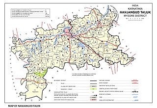
Nanjangud, officially known as Nanjanagudu, is a town in the Mysuru district of Indian state of Karnataka. Nanjangud lies on the banks of the river Kapila, 23 km from the city of Mysore. Nanjangud is famous for the Srikanteshwara Temple located here. Nanjangud is also called Dakshina Kashi. This town is also famous for a type of banana grown in the region called the Nanjanagoodu rasabale. Nanjangud's local administrative unit was designated as a Municipal Committee in 2015 by including Devirammanahalli and Kallahalli village.
Anekal is a major town and taluk of Bengaluru Urban district. It is a major town in the suburbs of Bengaluru city. Approximately 36 km from Bengaluru Centre and around 15 km from Hosur and Electronic City. Express lines run from Silk Board to Anekal passing through the National Highway and SH broadway thus providing excellent connectivity. It lies in the southern part of the Bangalore metropolitan area. Anekal is known for the Karaga and Dasara festivals.
Mulabagilu is a town and taluk headquarters of Mulabagilu taluk in the Kolar district in the state of Karnataka, India. It lies just off the National Highway 75 as the easternmost town of the state and a hill landmark.

Basavanagudi is a residential and commercial locality in the Indian city of Bangalore. It is located in South Bangalore, along the borders of Jayanagar. The name "Basavanagudi" refers to the Bull Temple, which contains a monolith statue of the Nandi Bull. The word Basava in Kannada means bull, and gudi means temple. Basavanagudi is one of the oldest and poshest areas of Bangalore. 4.6 km far from Bangalore City Railway Station and BMTC, and 38.7 km to Kempegowda International airport. The main commercial street of Basavanagudi is DVG Road, which is home to numerous retail businesses - several of them dating back to the 1920s and 1930s. Towards the middle of DVG Road is Gandhi Bazaar, known for its markets which sell fresh flowers, fruits, and vegetables. The neighbourhood includes several historic restaurants, notably Vidyarthi Bhavan, a vegetarian restaurant which was opened in 1943.

Melukote in Pandavapura taluk of Mandya district, Karnataka, in southern India, is one of the sacred places in Karnataka.It is built on rocky hills, known as Yadugiri, Yaadavagiri and Yadushailadeepa, overlooking the Cauvery valley. Melukote is about 51 km from Mysore and 133 km (83 mi) from Bangalore.

Kengeri is a suburb in Bangalore city. It is located on the western corridor along Mysore Road, bordered by Nagarbhavi to the north and Rajarajeshwari Nagar to the east.

Malavalli is a town and a taluka place in Mandya district in the Indian state of Karnataka. Malavalli town in history is quoted dates back to 27 March 1799 - Fourth Anglo Mysore War. Battle of Malavalli was fought between Tippu Sultan's Mysore Army against the British East India Company led by Arthur Wellesley. The men from the town fought fiercely and laid down their lives. The postal code of Malavalli is 571430.

Cheluvanarayana Swamy Temple, also known as Thirunarayanapura, is a temple in Melkote in the Mandya District of Karnataka, India. The temple is built on rocky hills which overlook the Kaveri valley. It is about 30 miles (48 km) from Mysore and 97 miles (156 km) from Bangalore.

The Pancharanga Kshetrams or Pancharangams is a group of five sacred Hindu temples, dedicated to Ranganatha, a form of the deity Vishnu, on the banks of the Kaveri River. The five Pancharanga Kshetrams in the order of their successive locations, on the banks of the Kaveri River are: The Srirangapatna called the Adi Rangam, the first temple on the banks of the Kaveri River from the upstream side; the Srirangam in Tamil Nadu known as Kasthuri Rangam or Anthya Rangam, Appalarangam or Koviladi at Tiruppernagar in Tamil Nadu, Parimala Ranganatha Perumal Temple at Tiruindalur in Mayiladuthurai or Mayuram and Vatarangam near Sirkazhi, also listed as Sri Renganatha Perumal Temple, Vadarengam, Tamil Nadu, 609108.
Bangalore (Bengaluru), the capital of Karnataka state, India, reflects its multireligious and cosmopolitan character by its more than 1000 temples, 400 mosques, 100 churches, 40 Jain derasars, three Sikh gurdwaras, two Buddhist viharas and one Parsi fire temple located in an area of 741 km2 of the metropolis. The religious places are further represented to include the few members of the Jewish community who are making their presence known through the Chabad that they propose to establish in Bengaluru and the fairly large number of the Baháʼí Faith whose presence is registered with a society called the Baháʼí Centre. In the demographically diverse, major economic hub and India's fastest-growing major metropolis of Bengaluru, the number of religious places of each religion reported reflects growth in proportion to the population growth. According to the 2001 census of India, 79.37% of Bangalore's population is Hindu, roughly the same as the national average. Muslims comprise 13.37% of the population, which again is roughly the same as the national average, while Christians and Jains account for 5.79% and 1.05% of the population, respectively, double that of their national averages. Anglo-Indians also form a substantial group within the city.
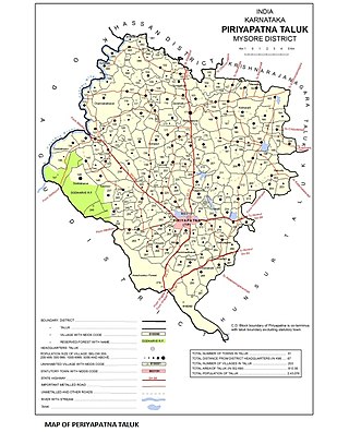
Periyapatna is a Town located in Peiriyapatna taluka of Mysore district. The town is divided into 23 wards in which elections are held every 5 years.

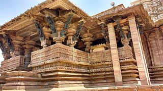
The Venugopala Swamy Temple located at Hosa Kannambadi, near Krishna Raja Sagara, is an example of Hoysala architecture in Karnataka, India. This temple was built in the 12th century AD around the same time as the Chennakesava Temple at Somanathapura, Mysore district.

Emerald Lingams are established in many Hindu Temples in Tamil nadu.
The earliest temples in Telangana include the Alampur Navabrahma Temples built during the 6th century CE by the Badami Chaulukyas.
There are nearly a thousand inscriptions in Tamil in the Southern Karnataka districts of Bangalore, Mysore, Kolar and Mandya in India. Nearly one third of these inscriptions are found in the Kolar District. Of all the inscriptions collected and published in the Epigraphia Carnatica Vol X for Kolar district, a fourth are in Tamil. The Tamil inscriptions start to appear around 1000 AD, after the conquest of the region by the Chola dynasty king Rajaraja I. Even after the Cholas left the area, the Hoysala and later the Vijaynagar kingdoms continued to use Tamil in the inscriptions.

Pushpagiri Temple Complex is a temple complex located in Kadapa district in Andhra Pradesh, India. Founded around 7th Century CE, it houses some of the oldest temple congregations in the region.

Hanumanthanagar, is a locality in the Banashankari suburb of South Bangalore. It gets its name from the Ramanjaneya Temple near the Kengal Hanumanthaiah Kalaa Soudha, which was built during the time of Kengal Hanumanthaiah, the then chief minister of Karnataka.


