
Salisbury Cathedral, formally the Cathedral Church of the Blessed Virgin Mary, is an Anglican cathedral in the city of Salisbury, England. The cathedral is considered the beau idéal of Early English Gothic design. Built over a relatively short period, some 38 years between 1220 and 1258, it has a unity and coherence that is unusual in medieval English cathedrals. The tower and spire were completed by 1330 and at 404 feet (123 m) is the tallest church spire in England.

William Butterfield was a British Gothic Revival architect and associated with the Oxford Movement. He is noted for his use of polychromy.

Mere is a market town and civil parish in Wiltshire, England. It lies at the extreme southwestern tip of Salisbury Plain, close to the borders of Somerset and Dorset. The parish includes the hamlets of Barrow Street, Burton, Charnage, Limpers Hill, Rook Street and Southbrook.

James Harris, FRS was an English politician and grammarian. He was the author of Hermes, a philosophical inquiry concerning universal grammar (1751).

Alton is a civil parish in Wiltshire, England. The parish includes the adjacent villages of Alton Barnes and Alton Priors, and the nearby hamlet of Honeystreet on the Kennet and Avon Canal. It lies in the Vale of Pewsey about 6 miles (10 km) east of Devizes.

Sherston is a village and civil parish about 5 miles (8 km) west of Malmesbury in Wiltshire, England. The parish is bounded to the north by the county boundary with Gloucestershire, and to the southeast by the Fosse Way, a Roman road. The parish includes the hamlets of Easton Town, immediately east of Sherston; Pinkney, further east along the Malmesbury road; and Willesley, to the north.

Donhead St Mary is a village and civil parish in southwest Wiltshire, England, on the county border with Dorset. The village lies about 2+1⁄2 miles (4.0 km) east of the Dorset town of Shaftesbury and stands on high ground above the River Nadder, which rises in the parish.

Fonthill Gifford is a village and civil parish in Wiltshire, England, to the north of the Nadder valley, 14 miles (23 km) west of Salisbury.

Brokenborough is a village and civil parish about 1+1⁄2 miles (2.4 km) northwest of Malmesbury, Wiltshire in England. The course of the Fosse Way Roman road forms the northwest boundary of the parish, and also the county boundary with neighbouring Gloucestershire. The Tetbury Avon, also called the Ingleburn, flows through the parish west of the village. The 2021 Census recorded the parish's population as 186. The village forms part of the ecclesiastical parish of Malmesbury and Brokenborough, in the Diocese of Bristol.
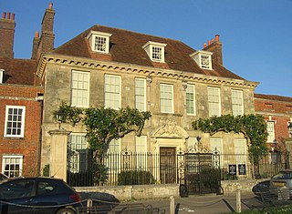
Mompesson House is an 18th-century house in the Cathedral Close, Salisbury, Wiltshire, England. The house is Grade I listed and has been in the ownership of the National Trust since 1975.

Hullavington is a village and civil parish in Wiltshire, England, just to the north of the M4 motorway. The village lies about 4 miles (6 km) southwest of Malmesbury and 5+1⁄2 miles (9 km) north of Chippenham.

Grittleton House is a country house in the village of Grittleton, Wiltshire, England, about 5+1⁄2 miles (9 km) northwest of the town of Chippenham. It is a building of historical significance and is Grade II* listed on the English Heritage Register.
Henry Woodyer (1816–1896) was an English architect, a pupil of William Butterfield and a disciple of A. W. N. Pugin and the Ecclesiologists.

Salisbury Cathedral School is a co-educational private school in Salisbury, Wiltshire, England, which was founded in 1091 by Saint Osmund. The choristers of Salisbury Cathedral are educated at the school.

Malmesbury is a town and civil parish in north Wiltshire, England, which lies approximately 14 miles (23 km) west of Swindon, 25 miles (40 km) northeast of Bristol, and 9 miles (14 km) north of Chippenham. The older part of the town is on a hilltop which is almost surrounded by the upper waters of the Bristol Avon and one of its tributaries.
Clarendon Park is a Grade I listed building, estate and civil parish located a short distance east of the city of Salisbury in Wiltshire, England. According to the 2011 census the population of the parish was 246.
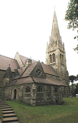
The Church of St Peter, Clyffe Pypard, Wiltshire is a parish church of the Diocese of Salisbury, England. It dates from the 13th and 15th centuries, and was restored by William Butterfield in 1860 and 1873–1874. The churchyard contains the grave of Nikolaus Pevsner and his wife Lola. St Peter's is a Grade I listed building and remains an active parish church.

St Osmund's Church is a Roman Catholic church in Salisbury, Wiltshire, England. It was designed by Augustus Pugin in the Gothic Revival style and built in 1847–1848. It is on Exeter Street, opposite Bishop Wordsworth's School, in the city centre. It is a Grade II listed building.

Myles Place, No. 68 The Close, Salisbury, Wiltshire, England is a former canonry, now a private home in the close of Salisbury Cathedral. The earliest known building on the site was a medieval residence for members of the cathedral clergy. The house was rebuilt in 1720. Considered the "stateliest house in the close", it is a Grade I listed building.

Harnham Gate is a historic gateway in the city of Salisbury in Wiltshire, England. Standing at the southern end of the cathedral close of Salisbury Cathedral, it is also known as the South Gate. It dates back to the fourteenth century and leads to a road connecting the suburb of Harnham on the southern side of the city, across the River Avon. The adjoining gatehouse was rebuilt in the late eighteenth or early nineteenth century. The gateway and gatehouse are now Grade I listed by Historic England.

