Kosovo Polje or Fushë Kosova is a town and municipality located in the Pristina district in central of Kosovo. According to the 2011 census, the town of Kosovo Polje has 12,919 inhabitants, while the municipality has 33,977 inhabitants.

Metohija or Dukagjini ) is a large basin and the name of the region covering the southwestern part of Kosovo. The region covers 35% (3,891 km2) of Kosovo's total area. According to the 2011 census, the population of the region is 700,577.

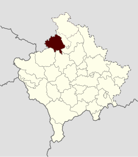
Klina is a town and municipality located in the Peć District of north-western Kosovo. According to the 2011 census, the town of Klina has 5,542 inhabitants, while the municipality has 38,496 inhabitants. It is located at the confluence of the river Klina into the White Drin.

Lipljan or Lipjan is a town and municipality located in the Pristina District of Kosovo. According to the 2011 census, the town of Lipljan has 6,870 inhabitants, while the municipality has 57,605 inhabitants.

The District of Gjilan or the District of Gnjilane is one of the seven districts of Kosovo. Its seat is in the city of Gjilan.

The Republic of Kosova was a self-declared proto-state in 1992. During its peak, it tried to establish its own parallel political institutions in opposition to the institutions of the Autonomous Province of Kosovo and Metohija held by the Republic of Serbia.
Zubin Potok is a town and municipality located in the Mitrovica District in Kosovo. As of 2015, it has an estimated population of 15,200 inhabitants. It covers an area of 335 km2 (129 sq mi), and consists of town and 63 villages.

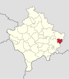
Kamenica or Dardana, or Kosovska Kamenica, is a town and municipality located in the Gjilan District of Kosovo. According to the 2011 census, the town of Kamenica has 7,331 inhabitants, while the municipality has 50,858 inhabitants.

Obilić, or Obiliq or Kastriot, is a town and municipality located in the Pristina District of Kosovo. According to the 2011 census, the town of Obilić has 6,864 inhabitants, while the municipality has 21,549 inhabitants. The municipality includes the town of Obilić and 19 villages.

Mališevo or Malisheva, is a town and municipality located in the Prizren District of Kosovo. According to the 2011 census, the town of Mališevo has 3,395 inhabitants, while the municipality has 54,613 inhabitants.

The Sitnica is a 90 km-long (56 mi) river in Kosovo. It flows into the Ibar at Kosovska Mitrovica, and it is the longest river that flows completely within Kosovo.

The Lab or Llap, is a river in the north-eastern part of Kosovo. The 72 km (45 mi) long right tributary to the Sitnica river, it is the main river in the Malo Kosovo depression. Near its origin are remains of medieval palace of Serbian king Milutin (1282-1321) called Vrhlab.

The Nerodimka, is a river in the Nerodimlje region of Kosovo, a 41 km-long left tributary to the Lepenac river. It represents Europe's only instance of a river bifurcation flowing into two seas, dividing into two irreversible branches. The left branch flows into the Black Sea, and the right branch flows into the Aegean Sea.
Since its declaration of independence from Serbia, enacted on 17 February 2008, international recognition of Kosovo has been mixed, and the international community continues to be divided on the issue.

Kosovo and Metohija, officially the Autonomous Province of Kosovo and Metohija, known as short Kosovo or simply Kosmet, refers to the region of Kosovo as defined in the Constitution of Serbia. The territory of the province is disputed between Serbia and the self-proclaimed Republic of Kosovo, the latter of which has de facto control. The region had functioned as part of Serbia for most of the period between 1912 and 1999.
Ranilug or Ranillug, is a village and municipality located in the Gjilan District of Kosovo. The municipality comprises 12 villages and as of 2015 has a population of 5,800 inhabitants.

The Kosova Academy of Sciences and Arts is the national academy of Kosovo.

The Republic of Central Albania was a short-lived unrecognised state established on October 16, 1913 with its administrative centre in Durrës, today in Albania.
Planjane is a village near Rečane and Brezovica, Prizren Municipality, Kosovo.
Harliaç is a village in municipality of Fushë Kosova, in Kosovo.