Malou Park

Last updated

Malou Park
The Chateau Malou in Park Malou, Brussels (3975302214).jpg
Malou Park and the Château Malou
Malou Park
TypePublic park
Location Woluwe-Saint-Lambert, Brussels-Capital Region, Belgium
Coordinates 50°50′31″N4°26′20″E / 50.84194°N 4.43889°E / 50.84194; 4.43889
Area8 ha (20 acres)

Malou Park (French : Parc Malou; Dutch : Maloupark) is an urban park in the Woluwe-Saint-Lambert municipality of Brussels, Belgium. It is in the valley of the Woluwe stream, to the south-east of the Woluwe Shopping Center. It is the municipality's oldest and biggest park.

Contents

History

A historic view of the park and the Chateau Malou from 1831 Chateau Malou.jpg
A historic view of the park and the Château Malou from 1831

The park was established on the marshy, boggy field surrounding the banks of the Struybeek stream, a tributary of the Woluwe. In 1774 the park featured seven fish ponds, a small hunting lodge called t'Speelgoet and a small reservoir. The gardens of the Speelgoet castle were laid out in the early 17th century by the hunting lodge's first known owners, a local family called Preud'homme. [1]

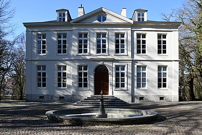
In 1776, the local merchant and banker Lambert de Lamberts built his château residence in the park, which was to be later renamed after Jules Malou, the most famous of its residents. The château's successive owners transformed the formal gardens to the park's present form, a landscape largely covered by trees.

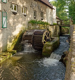
The municipality acquired the park in 1951. The remains of the previously large bogs or marshy areas can still be seen behind the Lindekemale watermill.

Situation

Malou Park lies to the east of the major thoroughfare Boulevard de la Woluwe/Woluwelaan, bordered from the north by the Avenue Debecker/Debeckerlaan, from the south by the Chaussée Stockel/Stokkelsesteenweg and from the east by the Chemin du Struybeken/Struybekenweg.

The park overlooks the valley of the Woluwe, which is a tributary of the large lake on the western side of the park. It covers some 8 hectares (20 acres) in total, including the last remaining pond, home to several ducks and swans. [2]

There are four principal recreation areas within the park: the walk along the banks of the brook and pond, renovated in 2001; the area of relaxation and culture in and around the Château Malou, with its contemporary art exhibitions; the botanical area with vegetable groupings such as alder trees, with ivy and lesser celandine, and a marshy alder plantation with nettles and meadowsweet; and a playground to the east of the château featuring a pirate boat.

Prominent sights

One of the most prominent features of the park is the Château Malou, a neoclassical castle built in 1776. In 1853, the building was occupied by the politician and statesman Jules Malou and both the château and the surrounding parkland bears his name.

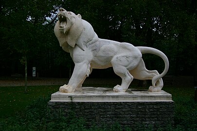
The Lindekemale watermill is a 12th-century structure on the northern side of the park, currently operating as a restaurant. On the same side, there is also an enormous statue of a lion.

See also

Related Research Articles

<span class="mw-page-title-main">Anderlecht</span> Municipality of the Brussels-Capital Region, Belgium

Anderlecht is one of the 19 municipalities of the Brussels-Capital Region, Belgium. Located in the south-western part of the region, it is bordered by the City of Brussels, Forest, Molenbeek-Saint-Jean, and Saint-Gilles, as well as the Flemish municipalities of Dilbeek and Sint-Pieters-Leeuw. In common with all of Brussels' municipalities, it is legally bilingual (French–Dutch).

<span class="mw-page-title-main">Etterbeek</span> Municipality of the Brussels-Capital Region, Belgium

Etterbeek is one of the 19 municipalities of the Brussels-Capital Region, Belgium. Located in the eastern part of the region, it is bordered by the municipalities of Auderghem, the City of Brussels, Ixelles, Schaerbeek, Woluwe-Saint-Lambert and Woluwe-Saint-Pierre. In common with all of Brussels' municipalities, it is legally bilingual (French–Dutch).

<span class="mw-page-title-main">Woluwe-Saint-Pierre</span> Municipality of the Brussels-Capital Region, Belgium

Woluwe-Saint-Pierre or Sint-Pieters-Woluwe is one of the 19 municipalities of the Brussels-Capital Region, Belgium. Located in the eastern part of the region, it is bordered by Etterbeek, Auderghem and Woluwe-Saint-Lambert, as well as the Flemish municipalities of Kraainem and Tervuren. In common with all of Brussels' municipalities, it is legally bilingual (French–Dutch).

<span class="mw-page-title-main">Senne (river)</span> River in Belgium

The Senne or Zenne is a small river that flows through Brussels, Belgium. Its source is in the village of Naast near the municipality of Soignies. It is an indirect tributary of the Scheldt, through the Dyle and the Rupel. It joins the Dyle at Zennegat in Battel, north of the municipality of Mechelen, only a few hundred metres before the Dyle itself joins the Rupel.

<span class="mw-page-title-main">Woluwe</span> Stream in Brussels, Belgium

The Woluwe is a stream that goes through several municipalities in the south-east and east of Brussels, Belgium, and is a right tributary of the Senne in Vilvoorde. The Kleine (little) Maalbeek is a tributary of the Woluwe in Kraainem. Many ponds formed along the stream over time, among which the Mellaerts Ponds still exist. The valley of the Woluwe crosses the municipalities of Auderghem, Watermael-Boitsfort, Woluwe-Saint-Pierre, Woluwe-Saint-Lambert, Kraainem, Zaventem, Machelen and Vilvoorde.

<span class="mw-page-title-main">Brussels Park</span> Park in Brussels, Belgium

Brussels Park is the largest urban public park in central Brussels, Belgium. Formerly known and still sometimes colloquially referred to as the Royal Park, it was the city's first public park, being originally laid out between 1776 and 1783 in a neoclassical style by the French architect Gilles-Barnabé Guimard and the Austrian landscape architect Joachim Zinner, as part of an urban project including the Place Royale/Koningsplein. The area of the rectangular park is 13.1 ha.

<span class="mw-page-title-main">Watermael-Boitsfort</span> Municipality of the Brussels-Capital Region, Belgium

Watermael-Boitsfort or Watermaal-Bosvoorde, often simply called Boitsfort in French or Bosvoorde in Dutch, is one of the 19 municipalities of the Brussels-Capital Region, Belgium. Located in the south-eastern part of the region, it is bordered by Auderghem, the City of Brussels, Ixelles, and Uccle, as well as the Flemish municipalities of Hoeilaart, Overijse and Sint-Genesius-Rode. In common with all of Brussels' municipalities, it is legally bilingual (French–Dutch).

<span class="mw-page-title-main">Merode station</span> Railway and metro station in Brussels, Belgium

Merode is a railway and metro station in Brussels, Belgium. It lies in the municipality of Etterbeek, near the border between Etterbeek, the City of Brussels and Schaerbeek. The metro end is under the Porte de Tervueren/Tervuursepoort, which is the start of the Avenue de Tervueren/Tervurenlaan, a major thoroughfare, while the mainline railway station end is under the Square Princesse Jean de Mérode/Prinses Jean de Mérodeplein. The two stations are connected by a long underground concourse punctuated by ticket barriers. The area is named in honour of the Princess Jean de Mérode.

<span class="mw-page-title-main">Château Malou</span> Neoclassical building in Brussels, Belgium

The Château Malou is a neoclassical building in the municipality of Woluwe-Saint-Lambert in Brussels, Belgium. The Château Malou is situated at an altitude of 52 metres (171 ft).

<span class="mw-page-title-main">Moulin Lindekemale</span> Watermill in Brussels, Belgium

The Lindekemale watermill is a 12th-century watermill located on the northern fringes of Malou Park in the Woluwe-Saint-Lambert municipality of Brussels, Belgium. It was operated by the nearby Woluwe river. The building is currently operating as a restaurant.

<span class="mw-page-title-main">Gribaumont metro station</span> Metro station in Brussels, Belgium

Gribaumont is a Brussels Metro station on line 1. It is located in the municipality of Woluwe-Saint-Lambert/Sint-Lambrechts-Woluwe, in the eastern part of Brussels, Belgium, and opened on 20 January 1976. It is located under the Avenue de Broqueville/De Broquevillelaan and takes its name from the nearby Avenue Louis Gribaumont/Louis Gribaumontlaan, named after the landowner who helped develop the area in the 1900s.

<span class="mw-page-title-main">Forest Park, Brussels</span> Park in Forest, Belgium

Forest Park or Vorst Park is a public park located in and named after the municipality of Forest in Brussels, Belgium. It was designed by Victor Besme and occupies an area of 13 hectares.

<span class="mw-page-title-main">Duden Park</span> Park in Forest, Belgium

Duden Park is a public park located in the municipality of Forest in Brussels, Belgium. It covers 24 hectares and has a level difference of 45 metres (148 ft), with its highest point being at an elevation of 90 metres (300 ft).

<span class="mw-page-title-main">Pierre van Gobbelschroy</span>

Pierre Louis Joseph Servais van Gobbelschroy was a conservative politician of the United Kingdom of the Netherlands in the first half of the 19th century.

<span class="mw-page-title-main">Schaerbeek Cemetery</span> Cemetery in Evere, Belgium

Schaerbeek Cemetery, officially Schaerbeek New Cemetery, is a cemetery belonging to Schaerbeek in Brussels, Belgium, where the municipality's inhabitants have the right to be buried. It is not located in Schaerbeek itself; rather it is partially in the neighbouring municipality of Evere, and partially in the village of Sint-Stevens-Woluwe in Zaventem, Flemish Brabant. The cemetery is adjacent to Brussels Cemetery and Evere Cemetery, but should not be confused with either.

Malou is a feminine given name and a French surname. As a given name, it is a contraction of the compound name Marie-Louise. The name has been well used for girls in Denmark and in the Philippines, where it is considered a contraction of María Lourdes. Malu is a variant spelling.

<span class="mw-page-title-main">Woluwe-Saint-Lambert</span> Municipality of the Brussels-Capital Region, Belgium

Woluwe-Saint-Lambert or Sint-Lambrechts-Woluwe is one of the 19 municipalities of the Brussels-Capital Region, Belgium. In common with all of Brussels' municipalities, it is legally bilingual (French–Dutch). In French, it is often spelt Woluwé-Saint-Lambert to reflect the Frenchified pronunciation of what was originally a Dutch place name, but the official spelling is without an accent. The Woluwe stream, from which it takes its name, flows through the municipality.

Elie Lainé (1829–1911) was a French landscape architect, chiefly remembered for the restoration of the gardens at Vaux-le-Vicomte, the layout of the grounds at Waddesdon Manor and the creation of numerous parks and gardens for King Leopold II of Belgium.

<span class="mw-page-title-main">UCLouvain Brussels Woluwe</span>

UCLouvain Bruxelles Woluwe, also known as Louvain-en-Woluwe or Alma, is a campus of the University of Louvain in Brussels, Belgium. The campus, built in the 1970s following the Leuven crisis, houses the Faculties of Medicine and Dentistry, Pharmacy and Biomedical Sciences and of Public Health, the Cliniques universitaires Saint-Luc, the university's main academic hospital, as well as many other institutions of higher education and a vast sports complex.

References

Citations

Bibliography