List of parks and gardens in Brussels

Last updated

Parc du Cinquantenaire/Jubelpark Parc du Cinquantenaire 30-05-06.JPG
Parc du Cinquantenaire/Jubelpark

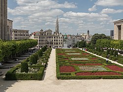
Brussels is one of the greenest capitals in Europe, with over 8,000 hectares of green spaces. [1] Vegetation cover and natural areas are higher in the outskirts, where they have limited the peri-urbanisation of the capital, but they decrease sharply towards the centre of Brussels; 10% in the central Pentagon, 30% of the municipalities in the first ring, and 71% of the municipalities in the second ring are occupied by green spaces.

Contents

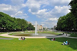
Many parks and gardens, both public and privately owned, are scattered throughout the city. In addition to this, the Sonian Forest is located in its southern part and stretches out over the three Belgian regions. As of 2017, it has been inscribed as a UNESCO World Heritage Site, the only Belgian component to the multinational inscription 'Primeval Beech Forests of the Carpathians and Other Regions of Europe'. [2]

A park or garden located on the territory of several municipalities is listed for each municipality.

Anderlecht

NameDistrictCoordinatesAreaImage
Astrid Park Meir Quarter 50°49′59″N4°17′53″E / 50.83306°N 4.29806°E / 50.83306; 4.29806 3563astridParkLake.jpg
Parc Forestier/Bospark Scheut 50°50′29″N4°18′40″E / 50.84139°N 4.31111°E / 50.84139; 4.31111 Anderlecht2019 32.jpg
Jean Vives ParkPonds Quarter 50°49′34″N4°16′56″E / 50.82611°N 4.28222°E / 50.82611; 4.28222 Parc Jean Vives 2.jpg
Pede ParkNeerpede 50°49′32″N4°16′19″E / 50.82556°N 4.27194°E / 50.82556; 4.27194 RAAGC.jpg
Parc des Étangs/VijversparkPonds Quarter 50°49′28″N4°17′4″E / 50.82444°N 4.28444°E / 50.82444; 4.28444 Parc des Etangs.jpg
Scherdemael ParkScherdemael/Scherdemaal 50°49′54″N4°17′15″E / 50.83167°N 4.28750°E / 50.83167; 4.28750 Scherdemael Park (1).jpg

Auderghem/Oudergem

NameDistrictCoordinatesAreaImage
Jean Massart Botanical Garden 50°48′50″N4°26′17″E / 50.81389°N 4.43806°E / 50.81389; 4.43806 Jardin Massart 01.JPG
Rouge Cloître/Roodklooster 50°48′28″N4°26′38″E / 50.80778°N 4.44389°E / 50.80778; 4.44389 13.61 ha (33.6 acres) Auderghem AB1f.jpg
Seny ParkTransvaal 50°48′34″N4°25′43″E / 50.80944°N 4.42861°E / 50.80944; 4.42861 Parc Seny on a snowy day, entering from Rue Charles Lemaire (Auderghem, Belgium) - grass.jpg
Val Duchesse/Hertoginnedal Val Duchesse/Hertoginnedal 50°49′13″N4°26′01″E / 50.82028°N 4.43361°E / 50.82028; 4.43361 Val Duchesse CH1bJPG.jpg
Woluwe ParkChant d'Oiseau/Vogelzang 50°49′44″N4°25′37″E / 50.829°N 4.427°E / 50.829; 4.427 69.28 ha (171.2 acres) 2286-00020 Parc de Woluwe (11).JPG

Berchem-Sainte-Agathe/Sint-Agatha-Berchem

NameDistrictCoordinatesAreaImage
Wilder WoodPotaarde 50°51′31″N4°17′26″E / 50.85861°N 4.29056°E / 50.85861; 4.29056 BERCHEM-SAINTE-AGATHE, rue Verte - eglise Sainte-Agathe (1) - BADEAUX 1.jpg

City of Brussels

Pentagon

NameDistrictCoordinatesAreaImage
Brussels Park Royal Quarter 50°50′41″N4°21′49″E / 50.8446°N 4.3637°E / 50.8446; 4.3637 13.1 ha (32 acres) [3] Brussels Park in summer 2007 1.JPG
Egmont Park Sablon/Zavel 50°50′19″N4°21′26″E / 50.83861°N 4.35722°E / 50.83861; 4.35722 1.42 ha (3.5 acres) [4] Egmont Park - Brussels, Belgium - DSC08309.jpg
Halle Gate Park Marolles/Marollen 50°49′59″N4°20′41″E / 50.83306°N 4.34472°E / 50.83306; 4.34472 3.2 ha (7.9 acres) [5] Tour de la Porte de Hal dans son jardin 01.jpg
Mont des Arts/Kunstberg Royal Quarter 50°50′38″N04°21′24″E / 50.84389°N 4.35667°E / 50.84389; 4.35667 1.4 ha (3.5 acres) [6] Brussels, Jardin du Mont des Arts foto5 2015-06-07 14.01.jpg
Square of the Small Sablon Sablon/Zavel 50°50′24″N04°21′22″E / 50.84000°N 4.35611°E / 50.84000; 4.35611 0.29 ha (0.72 acres) [7] Bruxelles-SquarePetitSablon.jpg

Eastern districts

NameDistrictCoordinatesAreaImage
Parc du Cinquantenaire/Jubelpark European Quarter 50°50′26″N4°23′34″E / 50.84056°N 4.39278°E / 50.84056; 4.39278 34.22 ha (84.6 acres) [8] Brussels Cinquantenaire R04.jpg
Leopold Park Leopold Quarter 50°50′18″N4°22′48″E / 50.83833°N 4.38000°E / 50.83833; 4.38000 6.43 ha (15.9 acres) [9] Parc Leopold-Bruxelles04.JPG
Maelbeek Valley Garden Leopold Quarter 50°50′38″N4°22′43″E / 50.84389°N 4.37861°E / 50.84389; 4.37861 Jardin du Maelbeek 7-9 B.jpg

Northern districts

NameDistrictCoordinatesAreaImage
Colonial Garden Laeken/Laken 50°53′18″N4°20′43″E / 50.88833°N 4.34528°E / 50.88833; 4.34528 Jardin colonial de Laeken - Brussels, Belgium - DSC07620.jpg
Florist of Stuyvenberg's Garden Laeken/Laken 50°53′07″N4°20′55″E / 50.88528°N 4.34861°E / 50.88528; 4.34861 Tuinen van de bloemist2.jpg
Laeken Park Laeken/Laken 50°53′33″N04°20′55″E / 50.89250°N 4.34861°E / 50.89250; 4.34861 28.79 ha (71.1 acres) [10] 0 Parc de Laeken - JPG1.jpg
Materials Quay Tour & Taxis 50°51′46″N4°20′58″E / 50.86278°N 4.34944°E / 50.86278; 4.34944
Maximilian Park Northern Quarter 50°51′44″N4°21′12″E / 50.86222°N 4.35333°E / 50.86222; 4.35333 Parc Maximilien.png
Osseghem Park Heysel/Heizel 50°53′44″N4°20′47″E / 50.89556°N 4.34639°E / 50.89556; 4.34639 15.9 ha (39 acres) Road in Parc d'Osseghem2.jpg
Sobieski Park Laeken/Laken 50°53′08″N4°20′43″E / 50.88556°N 4.34528°E / 50.88556; 4.34528 Parc Jean Sobieski - Brussels, Belgium - DSC07602.jpg
Tour & Taxis Park Tour & Taxis 50°52′13″N4°20′31″E / 50.87028°N 4.34194°E / 50.87028; 4.34194 Bruxelles - Parc Tour et Taxis 2015 (3).JPG

Southern districts

NameDistrictCoordinatesAreaImage
Bois de la Cambre/Ter Kamerenbos Louise/Louiza Quarter 50°48′11″N4°22′52″E / 50.80306°N 4.38111°E / 50.80306; 4.38111 122.34 ha (302.3 acres) [11] Brusel, Bois de la Cambre, jezero.jpg
King's Garden Louise/Louiza Quarter 50°49′18″N4°22′17″E / 50.82167°N 4.37139°E / 50.82167; 4.37139 Jardin du Roi Bruxelles Jardin du Roi Rue de Belle Vue 0 Rue du Buisson 0 Avenue Louise 0.jpg
La Cambre Abbey Louise/Louiza Quarter 50°49′08″N4°22′27″E / 50.81889°N 4.37417°E / 50.81889; 4.37417 Abb. de la Cambre 05.JPG

Etterbeek

NameDistrictCoordinatesAreaImage
Jean-Félix Hap GardenJourdan Quarter 50°50′04″N4°23′09″E / 50.83444°N 4.38583°E / 50.83444; 4.38583 Jean-Felix Hap Garden (1).jpg

Evere

Forest/Vorst

NameDistrictCoordinatesAreaImage
Duden Park Altitude Cent/Hoogte Honderd 50°49′01″N4°19′52″E / 50.81694°N 4.33111°E / 50.81694; 4.33111 22.76 ha (56.2 acres) DudenparkJustitiepaleis.jpg
Forest Park Altitude Cent/Hoogte Honderd 50°49′21″N4°20′13″E / 50.82250°N 4.33694°E / 50.82250; 4.33694 13 ha (32 acres) Parc de Forest - 20080325.JPG

Ganshoren

NameDistrictCoordinatesAreaImage
King Baudouin Park 50°52′53″N4°19′09″E / 50.88139°N 4.31917°E / 50.88139; 4.31917 Uitgedieptesiervijverwatervogels.jpg

Ixelles/Elsene

NameDistrictCoordinatesAreaImage
La Cambre Abbey Louise/Louiza Quarter 50°49′08″N4°22′27″E / 50.81889°N 4.37417°E / 50.81889; 4.37417 Abb. de la Cambre 05.JPG
Ixelles Ponds Flagey Quarter 50°49′25″N4°22′24″E / 50.82361°N 4.37333°E / 50.82361; 4.37333 5.5 ha (14 acres) Ixelles Ponds.JPG
Tenbosch Park Tenbosch/Tenbos 50°49′12″N4°21′53″E / 50.82000°N 4.36472°E / 50.82000; 4.36472 1.8 ha (4.4 acres) Parc Tenbosch.jpg

Jette

NameDistrictCoordinatesAreaImage
Dieleghem Wood Dieleghem/Dielegem 50°53′14″N4°19′26″E / 50.88722°N 4.32389°E / 50.88722; 4.32389 Dieleghembos.jpg
King Baudouin Park 50°52′53″N4°19′09″E / 50.88139°N 4.31917°E / 50.88139; 4.31917 Uitgedieptesiervijverwatervogels.jpg
Laerbeek Wood 50°53′16″N4°17′56″E / 50.88778°N 4.29889°E / 50.88778; 4.29889 Chalet Laarbeekbos herfst.jpg

Koekelberg

NameDistrictCoordinatesAreaImage
Elisabeth Park Basilica Quarter 50°51′54″N4°19′28″E / 50.86500°N 4.32444°E / 50.86500; 4.32444 21 ha (52 acres) Elisabeth parc Brussels.JPG

Molenbeek-Saint-Jean/Sint-Jans-Molenbeek

NameDistrictCoordinatesAreaImage
Albert ParkMachtens Quarter 50°51′05″N4°18′55″E / 50.85139°N 4.31528°E / 50.85139; 4.31528 Molenbeek - Parc Albert.jpg
Karreveld Park Karreveld Quarter 50°51′37″N4°18′55″E / 50.86028°N 4.31528°E / 50.86028; 4.31528 Chateau du Karreveld - Molenbeek.jpg
Marie-José ParkMachtens Quarter 50°51′5″N4°19′8″E / 50.85139°N 4.31889°E / 50.85139; 4.31889 Marie-Jose Park (2).jpg
Scheutbos ParkMettewie Quarter 50°51′00″N4°17′30″E / 50.85000°N 4.29167°E / 50.85000; 4.29167 Scheutbospark.jpg

Saint-Gilles/Sint-Gillis

NameDistrictCoordinatesAreaImage
Pierre Paulus Park 50°49′44″N4°20′57″E / 50.82889°N 4.34917°E / 50.82889; 4.34917 Brussel-Pierre Pauluspark (3).jpg
Forest Park Altitude Cent/Hoogte Honderd 50°49′21″N4°20′13″E / 50.82250°N 4.33694°E / 50.82250; 4.33694 Parc de Forest - 20080325.JPG
Hélène De Rudder Garden 50°49′46″N4°20′43″E / 50.82935°N 4.34533°E / 50.82935; 4.34533
Joséphine-Hortense Mairesse Park 50°49′42″N4°20′43″E / 50.82843°N 4.34516°E / 50.82843; 4.34516

Saint-Josse-ten-Noode/Sint-Joost-ten-Node

NameDistrictCoordinatesAreaImage
Botanical Garden of Brussels Northern Quarter 50°51′18″N4°21′55″E / 50.85488°N 4.365192°E / 50.85488; 4.365192 5.15 ha (12.7 acres) [12] Botanique 01.JPG

Schaerbeek/Schaarbeek

NameDistrictCoordinatesAreaImage
Josaphat Park Josaphat Quarter 50°51′44″N4°23′06″E / 50.86222°N 4.38500°E / 50.86222; 4.38500 30 ha (74 acres) Parc Josaphat (DSCF1381).jpg

Uccle/Ukkel

NameDistrictCoordinatesAreaImage
Brugmann Park 50°48′35″N4°21′07″E / 50.80972°N 4.35194°E / 50.80972; 4.35194 Parc Brugmann4.jpg
Montjoie Park 50°48′35″N4°21′27″E / 50.80972°N 4.35750°E / 50.80972; 4.35750 Parc Montjoie.jpg
Wolvendael Park 50°48′00″N4°20′38″E / 50.80000°N 4.34389°E / 50.80000; 4.34389 Wolvendael Park 01.jpg

Watermael-Boitsfort/Watermaal-Bosvoorde

NameDistrictCoordinatesAreaImage
Seny ParkTransvaal 50°48′34″N4°25′43″E / 50.80944°N 4.42861°E / 50.80944; 4.42861 Parc Seny on a snowy day, entering from Rue Charles Lemaire (Auderghem, Belgium) - grass.jpg
Tournay-Solvay Park 50°47′36″N4°24′40″E / 50.79333°N 4.41111°E / 50.79333; 4.41111 Tournay-Solvay Park (2).jpg

Woluwe-Saint-Lambert/Sint-Lambrechts-Woluwe

NameDistrictCoordinatesAreaImage
Malou Park 50°50′31″N4°26′20″E / 50.842°N 4.439°E / 50.842; 4.439 The Chateau Malou in Park Malou, Brussels (3975302214).jpg

Woluwe-Saint-Pierre/Sint-Pieters-Woluwe

NameDistrictCoordinatesAreaImage
Mellaerts Ponds 50°49′39″N4°26′02″E / 50.82750°N 4.43389°E / 50.82750; 4.43389 Etangs Mellaerts 02.jpg
Parmentier Park 50°49′47″N4°26′18″E / 50.82972°N 4.43833°E / 50.82972; 4.43833 Parc Parmentier.jpg
Woluwe ParkChant d'Oiseau/Vogelzang 50°49′44″N4°25′37″E / 50.829°N 4.427°E / 50.829; 4.427 69.28 ha (171.2 acres) 2286-00020 Parc de Woluwe (11).JPG

References

Citations

  1. "Parks and green spaces". be.brussels. Archived from the original on 3 February 2017.
  2. "Ancient and Primeval Beech Forests of the Carpathians and Other Regions of Europe". UNESCO World Heritage Centre. United Nations Educational, Scientific, and Cultural Organization. Archived from the original on 2 March 2012. Retrieved 3 September 2022.
  3. "Parc de Bruxelles". Bruxelles Environnement (in French). 31 March 2015. Retrieved 1 November 2019.
  4. "Parc d'Egmont". Bruxelles Environnement (in French). 31 March 2015. Retrieved 1 November 2019.
  5. "Parc de la Porte de Hal". Bruxelles Environnement (in French). 31 March 2015. Retrieved 1 November 2019.
  6. "Jardin du Mont des Arts". Bruxelles Environnement (in French). 31 March 2015. Retrieved 1 November 2019.
  7. "Square du Petit Sablon". Bruxelles Environnement (in French). 31 March 2015. Retrieved 1 November 2019.
  8. "Parc du Cinquantenaire". Bruxelles Environnement (in French). 31 March 2015. Retrieved 1 November 2019.
  9. "Parc Léopold". Bruxelles Environnement (in French). 31 March 2015. Retrieved 1 November 2019.
  10. "Parc de Laeken". Bruxelles Environnement (in French). 31 March 2015. Retrieved 1 November 2019.
  11. "Bois de la Cambre". Bruxelles Environnement (in French). 31 March 2015. Retrieved 1 November 2019.
  12. "Jardin Botanique". Bruxelles Environnement (in French). 31 March 2015. Retrieved 1 November 2019.

Bibliography