
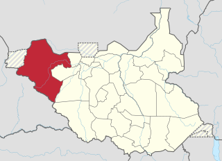
Northern Bahr el Ghazal(Arabic: ولاية شمال بحر الغزال) is a state in South Sudan. It has an area of 30,543 km2 and is part of the Bahr el Ghazal region. It borders East Darfur in Sudan to the north, Western Bahr el Ghazal to the west and south, and Warrap and the disputed region of Abyei to the east. Aweil is the capital of the state.

The Bahr el Ghazal is a region of northwestern South Sudan. Its name came from the river Bahr el Ghazal. The name translates as "sea of gazelles" from Arabic.

Aweil is a city in South Sudan and the capital of the Northern Bahr el Ghazal.
Aweil Airport is an airport serving the town of Aweil, in South Sudan.
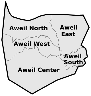
Aweil East County is a county in South Sudan.
The Kuru River, or Chel River is a stream in the South Sudanese states of Western Bahr el Ghazal and Northern Bahr el Ghazal. It is a headwater of the Lol River.
Aweil West County is an administrative area in Northern Bahr el Ghazal, South Sudan.
University of Northern Bahr el Ghazal (UNBEG) is a university in South Sudan.
The Lol River, or Loll River, is a stream in northern South Sudan that feeds the Bahr al-Arab, known locally as the Kiir River.
The Luwo are a Nilotic ethnic group that live in the western parts of South Sudan. They are part of a larger group of ethno-linguistically related Luo peoples of East Africa. They speak the Luwo language which is a Northern Luo language.

Aweil State was a state in South Sudan that existed between 2 October 2015 and 22 February 2020. It was located in the Bahr el Ghazal region and it borders Gogrial to the east, Lol to the west, Aweil East to the north, and Wau to the south. Its capital and largest city was Aweil.

Aweil East also known as Abiem, was a state in South Sudan that existed between 2 October 2015 and 22 February 2020. It had an estimated population of 571,728 people and an area of 6,172.23 KM square. It was located in northern-western South Sudan. Its capital and largest city was Wanyjok. The state is located in the Bahr el Ghazal region and it bordered Twic State and Gogrial State to the east, Aweil State to the south, Lol State to the west, the disputed Abyei State region to the northeast, and Sudan to the north.
The Lol State was a state of South Sudan with the capital in Raga, that existed between 2 October 2015 and 22 February 2020. It was located in the Bahr el Ghazal region, which is in the northwest section of the country. Lol state bordered Haut-Mbomou and Haute-Kotto in the Central African Republic to the west, South Darfur and East Darfur in Sudan to the north, the disputed region of Kafia Kingi to the northwest, Aweil East State to the northeast, Aweil State to the east, Gbudwe State to the south, and Wau State to the southeast. The state was created alongside 27 other states after a decree issuing the creation of 28 states took place. It was dissolved at the conclusion of the South Sudanese Civil War.
The 3rd Division is a division of the Sudan People's Liberation Army (SPLA). It’s based in Wunyiik, Aweil East County, Northern Bahr El Ghazal, and it’s believed to be the strongest group among 9 other military divisions. Mathiang Anyoor based in Pantit, Aweil West, is part of Division 3.

The South Sudan Patriotic Army is a South Sudanese rebel militia that takes part in the South Sudanese Civil War and serves as the military wing of Costello Garang Ring's South Sudan Patriotic Movement. Well armed and relatively numerous, the SSPA mostly operates in Northern Bahr el Ghazal and is considered to be one of the most powerful rebel groups in South Sudan.
The 2014 retreat from Western Bahr el Ghazal, also called the long march north, was an unorganized withdrawal by hundreds of Nuer Sudan People's Liberation Army (SPLA) deserters who sought to flee from Bahr el Ghazal to Sudan during the South Sudanese Civil War. After longstanding tensions between SPLA soldiers belonging to the Dinka and Nuer ethnic groups escalated on 25 April 2014, leading to a massacre of Nuer soldiers at Mapel in Western Bahr el Ghazal, a large number of Nuer SPLA soldiers deserted to escape ethnic prosecution and loyalist SPLA forces. Though some deserters joined SPLM-IO rebels or surrendered to the government, a large number of them marched northward, joined by other SPLA defectors from Northern Bahr el Ghazal. After covering over 400 kilometres (250 mi), this trek eventually arrived in Sudan on 4 August 2014, where they were disarmed.
Aweil South County, sometimes called Paliet, is an administrative area in Northern Bahr el Ghazal, South Sudan bordering Warrap State to the south. It is located in the south eastern part of NBGs. It is also known by the name Paliet, and one of the counties consisting of three major Dinka tribal groups of Ajak, Boncuai and Kongdeer. It was founded in 2000, headquartered in Boncuai in a place called Mangar-Gier. In 2004, the headquarters were shifted to Malek Alel in Ajak. It is boardered to the north by Aweil East and to the west by Aweil Centre, to the south east by Gogrial State, and to the southwest by Western Barh el Ghazal state respectively.
The Magadhik River is a river of South Sudan, a left tributary of the Lol River.
Aroyo is a town in Northern Bahr el Ghazal, South Sudan.
Awoda is a village in Northern Bahr el Ghazal, South Sudan.
