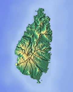
The Roseau River is a river in the Anse-la-Raye Quarter of the island country of Saint Lucia. It flows north and then west from the central highlands in the south of the island, reaching the Caribbean Sea to the north of the town of Anse la Raye. The Roseau river is also the longest in the country and is dammed by the John Compton Dam near Millet.

The Canaries River is a river on the island of Saint Lucia.

The Dennery River is the river on the southern end of the fishing village of Dennery on the island of Saint Lucia. The community of Dennery is built on its flood plain and in recent times has been the cause of serious flooding in the coastal community. It drains into the Atlantic Ocean.

The Dorée River is a river on the island of Saint Lucia.

The Migny River is a river on the island of Saint Lucia.

The Piaye River is a river in Laborie Quarter of the island nation of Saint Lucia.

Anse Mamin is bay on the coast with a small black sand beach in Soufrière District, Saint Lucia. It is located near Anse Chastanet and the two beaches are linked by a rocky path below the cliffs. Anse Mamin offers 12 kilometres (7.5 mi) of wooded trails.

The Anse Cochon River is a river in Saint Lucia.

The Dauphin River is a river in Gros Islet Quarter, Saint Lucia.

The Fond River is a river of Saint Lucia.

The Grande Rivière de l'Anse la Raye is a river of Saint Lucia.

The La Verdure River is a river of Saint Lucia.
The Little Vieux Fort River is a river in Vieux Fort Quarter of the island country of Saint Lucia. It is a tributary of the Vieux Fort River.

The L’Ivrogne River is a river in the Soufrière Quarter of the island nation of Saint Lucia. It flows into the L'Ivrogne Bay, Caribbean Sea.

The Mamiku River is a river of Saint Lucia.

The Marquis River is a river of Saint Lucia.

The Millet River is a river of Saint Lucia.

The Praslin River is a river of Saint Lucia.

The Trou Sallé River is a river of Saint Lucia.


