
Namakkal is a special grade municipality and the headquarters of Namakkal district in the Indian state of Tamil Nadu. It is the first ISO 14001-2004 certified municipality in Asia for environmental management, specifically the provision and maintenance of water supply, solid waste and sewage management, town planning, lighting and other social services. Namakkal is known as the Egg City due to its large egg production and Transport city.
Velagoundampatti is a place in Tamil Nadu, India. It is located on the state highway connecting the district headquarters, Namakkal with the other major town of this area, Thiruchengode. It is located along the State Highways SH-94 stretch, connecting Namakkal with Erode, Tirupur, Coimbatore. Velagoundampatti have two panjayath Aniyar and Marukalampatti.

Namakkal District is one of the 38 districts in the state of Tamil Nadu, India. The district was bifurcated from Salem District with Namakkal town as headquarters on 25 July 1996 and started to function independently from 1 January 1997. The district has seven taluks (subdivisions): Tiruchengode, Namakkal, Rasipuram, Paramathi Velur, Sendamangalam, Kumarapalayam, Kolli Hills and Mohanur. It has two revenue divisions: Tiruchengode and Namakkal. As of 2011 census, Namakkal district had a population of 1,726,601 with a sex-ratio of 986 females for every 1,000 males and Tiruchengode is the largest city in terms of population. Namakkal district is geographically affiliated to Kongu Nadu region. The district is famous for its large poultry industry, egg production and lorry bodybuilding industry, for which it is often referred to as "Egg City" and "Transport Hub of South India".
Rasipuram is a town in the Indian state of Tamil Nadu. It is the headquarters for the Rasipuram taluk. As of 2015, the town had a population of 88,584 and an area of 24 km2 (9.3 sq mi). It has 27 wards and steps have been taken to increase the wards to 33. Rasipuram is known for ghee and tapioca sago.
Kalappanaickenpatti is a panchayat town in Namakkal district in the Indian state of Tamil Nadu
Minjur is a town located in the outskirts of North Chennai, India. It is located in the Thiruvallur district in the Indian state of Tamil Nadu. Minjur is called 'Vada Kanchi' meaning North Kanchipuram. The town has two famous temples for Shiva and Vishnu, similar to Kanchipuram. The neighbourhood is served by Minjur railway station of the Chennai Suburban Railway Network.
Mohanur is a taluk in the Namakkal district of the Indian state of Tamil Nadu. The Mohanur Panchayat Union includes Mohanur Town, Pettapalayam, Manappalli, Rasipalayam, Kumaripalayam, Sengappalli, Ediyar, Peramandampalayam, Ariyur, Aniyapuram, and Valayapatti. It is linked to Tiruchirappalli, Salem, Erode, and Karur districts by road.
Paramathi Velur, a town in Paramathi-Velur taluk, Namakkal District, Tamil Nadu, India is situated just off the Srinagar - Kanyakumari National Highway 44 (India). This town is also called as Paramathi Velur, with STD Code 04268 & Postal code 638182.
Kamakkapalayam is a village in Salem district, Thalaivasal block in the Indian state of Tamil Nadu.
Chinna Veppanatham is a village located in Namakkal district, Tamil Nadu, India. This is one of the villages under Vasanthapuram Panchayat.
Thuthur is a village in the Ariyalur taluk of Ariyalur district, Tamil Nadu, India.
Andapuram is a village on the banks of Uppar river, in the Namakkal district of the Indian state of Tamil Nadu. Andapuram is a Gram Panchayat, falling in the Mohanur Revenue Block, Namakkal Taluk. Andapuram is in the Namakkal Assembly constituency and Namakkal Parliamentary constituency of India.

Pugalur is a municipality in Karur district in Tamil Nadu, India. It is divided into two parts, Nanjai and Punjai. Nanjai refers to land with plenty of water, and Punjai refers to land with few bodies of water. In the Nanjai area it is known as Nanjai Pugalur and in the Punjai area is known as Punjai Pugalur.
Vangal is a village in the Karur district of the Indian state of Tamil Nadu. It is situated 80 km (50 mi) from Tiruchirappalli and 7 miles from Karur city. Vangal is also known as Vangal-Kuppuchipalayam and Vangal Palayur.
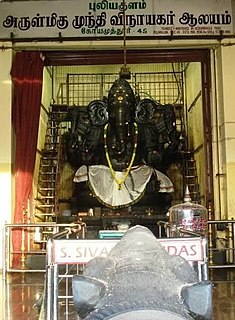
Puliakulam is a residential neighborhood in the city of Coimbatore. Arulmigu Munthi Vinayagar Temple and Abirami Amman Kovil are famous facecets of this place. This place has seen an influx of migrated population in the last decade, due to its accessibility and convenience. The Idol in Puliakulam Vinayagar Temple is one of the biggest single stone statues in Asia.
Mela Ilandaikulam is a village in Sankarankoil, Tirunelveli district, Tamil Nadu state, India. It is situated west of National Highway 7 between Kayathar and Devarkulam, 6 km from Devarkulam and 09 km from Kayathar. There is 1 higher secondary school, 1 middle school and 1 primary school.
Navalur Kuttapattu is a Suburb and Revenue Divisional headquarters of Srirangam taluk in Tiruchirappalli district, Tamil Nadu, India.It is located 12 km to the west of Tiruchirapalli. 4 km from Manikandam Union. 365 km from State capital Chennai.
Nettayampalayam is a village in Namakkal district in the Indian state of Tamil Nadu.
Nanjai Edayar is a village panchayat (council) located in the Namakkal district of Tamil Nadu state, India.

