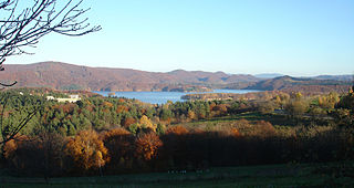
Polańczyk is a village in Lesko County, Subcarpathian Voivodeship, in south-eastern Poland. It lies in, and serves as the seat of, the administrative district of Gmina Solina. Polańczyk lies approximately 4 kilometres (2 mi) south-west of Solina, 14 km (9 mi) south-east of Lesko, and 80 km (50 mi) south of the regional capital Rzeszów. In 2002 the village had a population of 830.

Bachlawa is a village in the administrative district of Gmina Lesko, within Lesko County, Subcarpathian Voivodeship, in south-eastern Poland. It lies approximately 5 kilometres (3 mi) south of Lesko and 72 km (45 mi) south of the regional capital Rzeszów.

Dziurdziów is a village in the administrative district of Gmina Lesko, within Lesko County, Subcarpathian Voivodeship, in south-eastern Poland. It lies approximately 6 kilometres (4 mi) south-west of Lesko and 70 km (43 mi) south of the regional capital Rzeszów. It is not necessarily a large village, but the people that live there live in a spread-out area of single houses.

Hoczew is a village in the administrative district of Gmina Lesko, within Lesko County, Subcarpathian Voivodeship, in south-eastern Poland. It lies approximately 5 kilometres (3 mi) south of Lesko and 71 km (44 mi) south of the regional capital Rzeszów.
Łączki is a village in the administrative district of Gmina Lesko, within Lesko County, Subcarpathian Voivodeship, in south-eastern Poland. It is approximately 4 kilometres (2 mi) southeast of Lesko and 70 km (43 mi) south of the regional capital of Rzeszów.
Weremień is a village in the administrative district of Gmina Lesko, within Lesko County, Subcarpathian Voivodeship, in south-eastern Poland. It lies approximately 3 kilometres (2 mi) south of Lesko and 69 km (43 mi) south of the regional capital Rzeszów.
Mchawa is a village in the administrative district of Gmina Baligród, within Lesko County, Subcarpathian Voivodeship, in south-eastern Poland. It lies approximately 4 kilometres (2 mi) north of Baligród, 13 km (8 mi) south of Lesko, and 77 km (48 mi) south of the regional capital Rzeszów.
Nowosiółki is a village in the administrative district of Gmina Baligród, within Lesko County, Subcarpathian Voivodeship, in south-eastern Poland. It lies approximately 7 kilometres (4 mi) north of Baligród, 9 km (6 mi) south of Lesko, and 73 km (45 mi) south of the regional capital Rzeszów.
Stężnica is a village in the administrative district of Gmina Baligród, within Lesko County, Subcarpathian Voivodeship, in south-eastern Poland. It lies approximately 5 kilometres (3 mi) south-east of Baligród, 16 km (10 mi) south of Lesko, and 82 km (51 mi) south of the regional capital Rzeszów.
Buk is a village in the administrative district of Gmina Cisna, within Lesko County, Subcarpathian Voivodeship, in south-eastern Poland, close to the border with Slovakia. It lies approximately 6 kilometres (4 mi) north-east of Cisna, 26 km (16 mi) south of Lesko, and 92 km (57 mi) south of the regional capital Rzeszów.
Dołżyca is a village in the administrative district of Gmina Cisna, within Lesko County, Subcarpathian Voivodeship, in south-eastern Poland, close to the border with Slovakia. It lies approximately 2 kilometres (1 mi) north-east of Cisna, 29 km (18 mi) south of Lesko, and 94 km (58 mi) south of the regional capital Rzeszów.
Kalnica is a village in the administrative district of Gmina Cisna, within Lesko County, Subcarpathian Voivodeship, in south-eastern Poland, close to the border with Slovakia. It lies approximately 8 kilometres (5 mi) east of Cisna, 33 km (21 mi) south of Lesko, and 99 km (62 mi) south of the regional capital Rzeszów.
Krzywe is a village in the administrative district of Gmina Cisna, within Lesko County, Subcarpathian Voivodeship, in south-eastern Poland, close to the border with Slovakia. It lies approximately 4 kilometres (2 mi) south-east of Cisna, 32 km (20 mi) south of Lesko, and 97 km (60 mi) south of the regional capital Rzeszów.
Liszna is a village in the administrative district of Gmina Cisna, within Lesko County, Subcarpathian Voivodeship, in south-eastern Poland, close to the border with Slovakia. It lies approximately 3 kilometres (2 mi) south-west of Cisna, 31 km (19 mi) south of Lesko, and 96 km (60 mi) south of the regional capital Rzeszów.
Smerek is a village in the administrative district of Gmina Cisna, within Lesko County, Subcarpathian Voivodeship, in south-eastern Poland, close to the border with Slovakia. It lies approximately 9 kilometres (6 mi) south-east of Cisna, 34 km (21 mi) south of Lesko, and 100 km (62 mi) south of the regional capital Rzeszów.
Solinka is a village in the administrative district of Gmina Cisna, within Lesko County, Subcarpathian Voivodeship, in south-eastern Poland, close to the border with Slovakia. It lies approximately 8 kilometres (5 mi) south-west of Cisna, 35 km (22 mi) south of Lesko, and 98 km (61 mi) south of the regional capital Rzeszów.
Rajskie is a village in the administrative district of Gmina Solina, within Lesko County, Subcarpathian Voivodeship, in south-eastern Poland. It lies approximately 8 kilometres (5 mi) south of Solina, 21 km (13 mi) south-east of Lesko, and 87 km (54 mi) south-east of the regional capital Rzeszów.
Terka is a village in the administrative district of Gmina Solina, within Lesko County, Subcarpathian Voivodeship, in south-eastern Poland. It lies approximately 10 kilometres (6 mi) south of Solina, 21 km (13 mi) south of Lesko, and 88 km (55 mi) south of the regional capital Rzeszów.
Werlas is a village in the administrative district of Gmina Solina, within Lesko County, Subcarpathian Voivodeship, in south-eastern Poland. It lies approximately 5 kilometres (3 mi) to the south of Solina, 18 km (11 mi) south-east of Lesko, and 84 km (52 mi) south-east of the regional capital Rzeszów.

Wołkowyja is a village in the administrative district of Gmina Solina, within Lesko County, Subcarpathian Voivodeship, in south-eastern Poland. It lies approximately 7 kilometres (4 mi) south-west of Solina, 17 km (11 mi) south of Lesko, and 84 km (52 mi) south of the regional capital Rzeszów.


