Belize is a small Central American nation, located at 17°15' north of the equator and 88°45' west of the Prime Meridian on the Yucatán Peninsula. It borders the Caribbean Sea to the east, with 386 km of coastline. It has a total of 542 km of land borders—Mexico to the north-northwest (272 km) and Guatemala to the south-southwest (266 km). Belize's total size is 22,966 km², of which 22,806 km² is land and 160 km² is water.

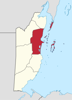
Toledo District is the southernmost district in Belize, and Punta Gorda is the District capital. It is the least developed region in the country, and it features some of the most pristine rainforests, extensive cave networks, coastal lowland plains, and offshore cays. Toledo is home to a wide range of cultures: Mopan and Kekchi Maya, Creole, the Garifuna, East Indians, Mennonites, Mestizos, and descendants of US Confederate settlers.

Ladyville is the largest village in the country of Belize, eight miles northwest of Belize City in the Belize District. The Philip Goldson Highway connects Ladyville to Belize City.
Chunox is an isolated village in the Corozal District of the nation of Belize. Chunox is located on the east bank of Laguna Seca towards the south end of the lagoon at an altitude of 3 meters above sea level. According to the 2000 census, Chunox had a population of 1,143 people.

Chetumal is a city on the east coast of the Yucatán Peninsula in Mexico. It is the capital of the state of Quintana Roo and the municipal seat of the Municipality of Othón P. Blanco. In 2010 it had a population of 151,243 people.

Bacalar is the municipal seat and largest city in Bacalar Municipality in the Mexican state of Quintana Roo, about 40 kilometres (25 mi) north of Chetumal, at 18° 40' 37" N, 88° 23' 43" W. In the 2010 census the city had a population of 11,084 people. At that time it was still a part of Othón P. Blanco, and was its second-largest city (locality), after Chetumal.

Nim Li Punit is a Maya Classic Period site in the Toledo District of the nation of Belize, located 40 kilometres north of the town of Punta Gorda, at 16° 19' N, 88° 47' 60W. Nim Li Punit is sometimes known as Big Hat or Top Hat; the name is Kekchi Maya for "Big Hat", referring to the large elaborate head-dress on a stela sculpture found on site depicting one of the site's ancient kings.

Placencia is a small village located in the Stann Creek District of Belize.

Gales Point is a village in Belize District in the nation of Belize, Central America. The village is on a peninsula in the Southern Lagoon In 2000, Gales Point had a population of about 500 people, most of whom subsist on fishing and farming.

Lamanai is a Mesoamerican archaeological site, and was once a major city of the Maya civilization, located in the north of Belize, in Orange Walk District. The site's name is pre-Columbian, recorded by early Spanish missionaries, and documented over a millennium earlier in Maya inscriptions as Lam'an'ain. Lamanai is renowned for its exceptionally long occupation spanning three millennia, beginning in the Early Preclassic Maya period and continuing through the Spanish and British Colonial periods, into the 20th century. Unlike most Classic-period sites in the southern Maya lowlands, Lamanai was not abandoned at the end of the 10th century AD.

The Gulf or Bay of Honduras is a large inlet of the Caribbean Sea, indenting the coasts of Belize, Guatemala, and Honduras. From north to south, it runs for approximately 200 km from Dangriga, Belize, to La Ceiba, Honduras.
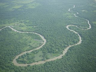
The Belize River runs 290 kilometres (180 mi) through the center of Belize. It drains more than one-quarter of the country as it winds along the northern edge of the Maya Mountains to the sea just north of Belize City. The Belize river valley is largely tropical rain forest.

Monkey River is a coastal watercourse in southern Belize that rises in the Maya Mountains and discharges to the Caribbean Sea near Monkey River Town. One of Belize's major rivers, Monkey River has northern headwaters which originate in the Cockscomb Basin Wildlife Sanctuary, where the Swasey Branch drains the East Basin of that wildlife sanctuary. Further south, the Bladen Branch watercourse drains the eastern slopes of the Maya Mountains including the ancient Mayan settlement areas of Lubaantun and Nim Li Punit. These two watercourses join to form the Monkey River approximately 16 kilometres upstream from the mouth of the Monkey River. The Monkey River is readily navigated throughout the year using small boats, but navigation above the major confluence becomes more difficult due to lack of depth when the dry season starts about February. Habitats in this watershed provide cover for such diverse species as the ocelot, jaguar, Guatemalan black howler, bare-throated tiger heron, Morelet's crocodile, fer-de-lance and manatee.

The New River, also Rio Nuevo, is a river in northern Belize. As the longest river that is entirely confined to Belize, it drains primarily the eastern part of the Orange Walk District during its north-northeasterly course and empties into the Chetumal Bay. The river also forms the New River Lagoon, the largest body of fresh water in Belize, just east of the Maya temples of Lamanai. The New River is a habitat for numerous types of fish, birds, as well as crocodiles.
Gardenia is a village in Belize District, Belize located about 20 miles (32 km) north of Belize City.

Tourism in Belize has grown considerably recently, and it is now the second largest industry in the nation. Belizean Prime Minister Dean Barrow has stated his intention to use tourism to combat poverty throughout the country. The growth in tourism has positively affected the agricultural, commercial, and finance industries, as well as the construction industry. The results for Belize's tourism-driven economy have been significant, with the nation welcoming almost one million tourists in a calendar year for the first time in its history in 2012.

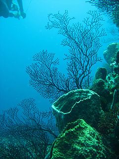
Turneffe Atoll is located southeast of Ambergris Caye and Caye Caulker, off the coast of Belize in Central America, 20 miles from Belize City, is one of three atolls of the Belize Barrier Reef, besides Glover's Reef and Lighthouse Reef. It is approximately 30 miles long and 10 miles wide, making it the largest coral atoll in Belize and in the Mesoamerican Barrier Reef System. The atoll was officially declared a marine reserve on November 22, 2012.

San Antonio is a village in the Toledo District of Belize. It is the largest Maya settlement in Belize, with a population of approximately 1,000 people, predominantly Mopan Maya. About 88% of the inhabitants are Catholic, with 8% belonging to other Christian denominations, and 4% being non-denominational. Along with 29 other mission parishes in the Toledo District, it is pastored by Jesuits from St. Peter Claver church in Punta Gorda.
Community Baboon Sanctuary is a protected area in Belize. It was established in 1985 to help address the threats of agriculture, logging and hunting of the black howler monkey (‘baboon”) and to educate locals and visitors about the importance of biodiversity, sustainability, and to promote the economic development of the Bermudian Landing community.
The Gales Point Wildlife Sanctuary is in the Belize district approximately 23.7 southwest of Belize City and 34 km north of Dangriga. The Sanctuary includes Southern Lagoon, Sapodilla Lagoon, Western Lagoon, Quashie Trap Lagoon and a portion of the Manatee river. It has a shoreline of 66-foot that is along all the lagoons and waterways except for the peninsula. The Wildlife Sanctuary covers a complex matrix of creeks, mangroves, mudflats and brackish lagoons. Both the rivers and creeks drains into the lagoon from the west. The lagoon is also connected to the Caribbean Sea via the Bar River.