Related Research Articles

The Pulwama district is a district in the Indian Union territory of Jammu and Kashmir, located in the south of Srinagar. The district headquarters of Pulwama district are located in Pulwama city.

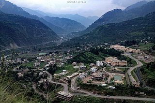
Pulwama is a city and notified area council in the Pulwama district of the Indian-administered territory of Jammu and Kashmir. It is located approximately 25 kilometres (16 mi) south of the summer capital of Srinagar.

Poonch or Punch is a district in Jammu and Kashmir, India. With headquarters the town of Poonch, it is bounded by the Line of Control on three sides. The 1947-48 war between India and Pakistan divided the earlier district into two parts. One went to Pakistan and the other became part of the then Indian state of Jammu and Kashmir.

Awantipora or Avantipur or Aavantipur, known as Woontpor in Kashmiri, is a town on the banks of the river Jhelum in the Pulwama district of the Indian union territory of Jammu and Kashmir. It is on the Jammu-Srinagar National Highway, south of Srinagar and north of Anantnag. Awantipora was named after the Kashmiri king Avantivarman and has the ruins of two 9th century Hindu temples built by him.

Shopian or Shupiyan, known as Shupyan in Kashmiri, is an administrative division of the Shopian district, located in southern part of Kashmir Valley, of Jammu and Kashmir, India. Shopian is also called the apple town of Kashmir, as majority of the population engages in apple growing practices which also provides employment to more than 60% of the population.

Kupwara district is one of the 10 districts located in the Kashmir Valley region of Jammu and Kashmir, India. The river Kishenganga, originating from the Himalayas, flows through the outer areas of the district from east to west.
Ramban is a district in the Indian union territory of Jammu and Kashmir, located in the lap of the Pir Panjal range. It is one the three districts of Chenab Valley, as it was carved out as a district from erstwhile Doda district in 2007.
Botingoo is a village in the Zaingair area of Sopore in Baramulla District in the Indian union territory of Jammu and Kashmir. The famous personalities of the village are Prof. Abdul gani bhat, Junaidbhat photographer Etc
Rafiabad is a tehsil in Baramulla of Jammu and Kashmir, India. The tehsil headquarters are in Rohama town. It is located to the north of Baramulla, about 12 km from the district headquarters, and 70 km from the state capital Srinagar to the west. The headquarters of Rafiabad Assembly Constituency are in Rohama town.
Ladoora is a notified area and village in the Baramulla district, Jammu and Kashmir, India. It is located on the banks of River Jhelum. It is approximately seven kilometers from Sopore and 8 kilometres from Baramulla. Ladoora has a playground known by the name of Nagbal cricket ground. Ladoora Rafiabad is known for fruit business.
Bon Dialgam is a village in the Anantnag district in the Indian union territory of Jammu and Kashmir.
Luk Bawan is a village in Doru Shahabad Tehsil of Anantnag district in Jammu and Kashmir, India.
Sangam is village situated on Jammu-Srinagar National Highway in Bijbehara tehsil of Anantnag district in Jammu and Kashmir, India.
Langate is a tehsil in Kupwara district of Jammu and Kashmir, India. Langate tehsil headquarters is Langate town. It is located 20 km towards south from district headquarters Kupwara. 66 km from State capital Srinagar, Jammu towards East.
Hillar Shahabad is a village in Doru Tehsil in the Anantnag district of Jammu and Kashmir, India.
Surankote Tehsil is a tehsil of the Poonch district in the Indian union territory of Jammu and Kashmir. It is headquartered at the Surankote.

Jammu and Kashmir is a region administered by India as a union territory and consisting of the southern portion of the larger Kashmir region, which has been the subject of a dispute between India and Pakistan since 1947, and between India and China since 1962. The Line of Control separates Jammu and Kashmir from the Pakistani-administered territories of Azad Kashmir and Gilgit-Baltistan in the west and north. It lies to the north of the Indian states of Himachal Pradesh and Punjab and to the west of Ladakh, which is also subject to the dispute as a part of Kashmir, and administered by India as a union territory.
Kralpora is a Tehsil and a village in Kupwara district of the Indian administered union territory of Jammu and Kashmir. The village is located just 15 kilometres from district headquarters Kupwara town.
Wavoora is a village in Kupwara district of the Indian union territory of Jammu and Kashmir. The town is located 13 km (8.1 mi) from district headquarters Kupwara.
Bagati Kani Pora or B.K. Pora is a village and municipality in Budgam district of the Indian union territory of Jammu and Kashmir.
References
- ↑ "The Jammu and Kashmir Official Languages Act, 2020" (PDF). The Gazette of India. 27 September 2020. Retrieved 27 September 2020.
- ↑ "Parliament passes JK Official Languages Bill, 2020". Rising Kashmir. 23 September 2020. Retrieved 30 May 2021.
- ↑ "Census of India: Search Details". censusindia.gov.in. Retrieved 6 November 2021.