Manchester (ancient parish)

Last updated

Manchester
Manchester parish map.svg
History
Status Ecclesiastical parish
   HQ St Mary's, Christ Church
Subdivisions
  Type Townships

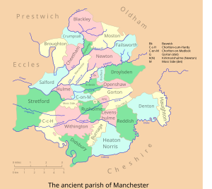
Manchester was an ancient ecclesiastical parish of the hundred of Salford, in Lancashire, England. It encompassed several townships and chapelries, including the then township of Manchester (now Manchester city centre). Other townships are now parts of the Anglican Diocese of Manchester and/or Greater Manchester.

Lancashire County of England

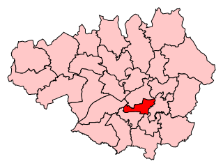
Lancashire is a ceremonial county in North West England. The administrative centre is Preston. The county has a population of 1,449,300 and an area of 1,189 square miles (3,080 km2). People from Lancashire are known as Lancastrians.

In England, a township is a local division or district of a large parish containing a village or small town usually having its own church. A township may or may not be coterminous with a chapelry, manor, or any other minor area of local administration.

Manchester city centre central business district of the City of Manchester, England

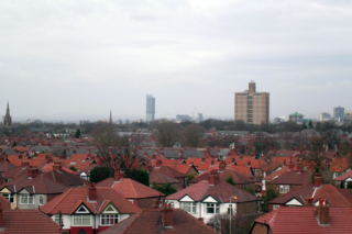
Manchester city centre is the central business district of Manchester, England, within the boundaries of Trinity Way, Great Ancoats Street and Whitworth Street. The City Centre ward had a population of 17,861 at the 2011 census.

Contents

In the Domesday Book the parish of Manchester is recorded as including St Michael's Church in Ashton-under-Lyne as well as the mother church of St Mary's in Manchester. Although by the 13th century Ashton had formed its own separate parish, the advowson was held by Manchester as late as 1458. [1]

Domesday Book 11th-century survey of landholding in England as well as the surviving manuscripts of the survey

Domesday Book is a manuscript record of the "Great Survey" of much of England and parts of Wales completed in 1086 by order of King William the Conqueror. The Anglo-Saxon Chronicle states:

Then, at the midwinter [1085], was the king in Gloucester with his council .... After this had the king a large meeting, and very deep consultation with his council, about this land; how it was occupied, and by what sort of men. Then sent he his men over all England into each shire; commissioning them to find out "How many hundreds of hides were in the shire, what land the king himself had, and what stock upon the land; or, what dues he ought to have by the year from the shire."

St Michael and All Angels Church, Ashton-under-Lyne Grade I listed church in the United Kingdom

St. Michael's Church in Ashton-under-Lyne, Greater Manchester, is a Grade I Listed Building. It is one of 116 surviving medieval parish churches in the North West. The church dates back to at least 1262, and a church on the site was mentioned in the Domesday Book. The church was rebuilt in the fifteenth century; however little of the previous church remains after it was rebuilt again in the nineteenth century.

Ashton-under-Lyne Market town in the Metropolitan Borough of Tameside, Greater Manchester, England

Ashton-under-Lyne is a market town in Tameside, Greater Manchester, England. The population was 45,198 at the 2011 census. Historically in Lancashire, it is on the north bank of the River Tame, in the foothills of the Pennines, 6.2 miles (10.0 km) east of Manchester.

Townships

In 1866 the townships became recognised as separate civil parishes. Part, but not all, of this area was in the municipal borough of Manchester, which expanded with the decades. In 1896 the parishes of the City of Manchester outside the remaining Manchester parish were re-organised as North Manchester and South Manchester parishes, which were themselves re-organised as a single civil parish of Manchester in 1916, while the parishes in the county borough of Salford were united as a single civil parish in 1919. [2]

Civil parish territorial designation and lowest tier of local government in England, UK

In England, a civil parish is a type of administrative parish used for local government, they are a territorial designation which is the lowest tier of local government below districts and counties, or their combined form, the unitary authority. Civil parishes can trace their origin to the ancient system of ecclesiastical parishes which historically played a role in both civil and ecclesiastical administration; civil and religious parishes were formally split into two types in the 19th century and are now entirely separate. The unit was devised and rolled out across England in the 1860s.

Municipal boroughs were a type of local government district which existed in England and Wales between 1835 and 1974, in Northern Ireland from 1840 to 1973 and in the Republic of Ireland from 1840 to 2002. Broadly similar structures existed in Scotland from 1833 to 1975 with the reform of royal burghs and creation of police burghs.

North Manchester was, from 1896 to 1916, a township within the Poor Law Union of Manchester, England. North Manchester was a local government sub-district used for the administration of Poor Law legislation; it was an inter-parish unit for social security. Although abolished in 1916, the name North Manchester endured for the area, and is still applied to the northern parts of the city, for instance as a registration district up until 1974.

Ardwick district of Manchester, England

Ardwick is a district of Manchester in North West England, one mile south east of the city centre. The population of the Ardwick Ward at the 2011 census was 19,250.

Blackley area of the city of Manchester, England

Blackley is a suburban area of Manchester, England. Historically in Lancashire, it is approximately 4.5 miles (7.2 km) north of Manchester city centre, on the River Irk.

County Borough of Salford former district of England

Salford was, from 1844 to 1974, a local government district in the northwest of England, coterminate with Salford. It was granted city status in 1926.

See also

Related Research Articles

Tameside Metropolitan borough in England

The Metropolitan Borough of Tameside is a metropolitan borough of Greater Manchester in North West England. It is named after the River Tame, which flows through the borough and spans the towns of Ashton-under-Lyne, Audenshaw, Denton, Droylsden, Dukinfield, Hyde, Mossley and Stalybridge plus Longdendale. Its western border is approximately 4 miles (6.4 km) east of Manchester city centre. It borders High Peak in Derbyshire to the east, the Metropolitan Borough of Oldham to the north, the Metropolitan Borough of Stockport to the south, and the City of Manchester to the west. As of 2011 the overall population was 219,324.

Denton, Greater Manchester town in Tameside, Greater Manchester, England

Denton is a town in the Metropolitan Borough of Tameside, Manchester, England, five miles (8 km) east of Manchester city centre. Historically part of Lancashire, it had a population of 36,591 at the 2011 Census.

Withington suburb of Manchester, England

Withington is a suburb of south Manchester, England. Historically part of Lancashire, it lies 4 miles (6.4 km) from Manchester city centre, about 0.4 miles (0.6 km) south of Fallowfield, 0.5 miles (0.8 km) north-east of Didsbury and 1 mile (1.6 km) east of Chorlton-cum-Hardy. Withington has a population of just over 14,000 people, reducing at the 2011 census to 13,422.

Audenshaw town in Tameside, Greater Manchester, England

Audenshaw is a town in Tameside, Greater Manchester, England, on the River Tame 1.8 miles (2.9 km) south-west of Ashton-under-Lyne and 4.9 miles (7.9 km) east of Manchester. Historically part of Lancashire, in 2011 it had a population of 11,419.

Salford Hundred

The Salford Hundred is one of the subdivisions of the historic county of Lancashire, in Northern England. Its name alludes to its judicial centre being the township of Salford. It is also known as the Royal Manor of Salford and the Salford wapentake.

Burnage suburb of the city of Manchester in North West England

Burnage is a suburb of the city of Manchester in North West England, about 4 miles (6.4 km) south of Manchester city centre and bisected by the dual carriageway of Kingsway. The population of the Burnage Ward at the 2011 census was 15,227. It lies between Withington to the west, Levenshulme to the north, Heaton Chapel to the east and Didsbury and Heaton Mersey to the south.

Denton and Reddish (UK Parliament constituency) Parliamentary constituency in the United Kingdom

Denton and Reddish is a constituency represented in the House of Commons of the UK Parliament since 2005 by Andrew Gwynne of the Labour Party.

Manchester Gorton (UK Parliament constituency) Parliamentary constituency in the United Kingdom

Manchester Gorton is a constituency represented in the House of Commons of the UK Parliament by Labour's Afzal Khan, who was elected at the 2017 general election.

Haughton Green village in United Kingdom

Haughton Green is a large village in Tameside, Greater Manchester, England. It formed part of the ancient township of Haughton, Lancashire, along with Haughton Dale, Higher Haughton, Lower Haughton, Haughton Hall and Haughton itself.

Haughton, Greater Manchester

Haughton is a township forming the eastern portion of Denton, Tameside in Greater Manchester. The township probably dates from the Anglo-Saxon times, and was first recorded as Halcton or Halghton in the thirteenth century. In Saxon, Haughton means 'settlement' (ton) on 'low-lying land' (Haugh), and probably refers to the ancient township's location in the Tame Valley.

Greater Manchester Built-up Area Conurbation in England

The Greater Manchester Built-up Area is an area of land defined by the Office for National Statistics (ONS), consisting of the large conurbation that encompasses the urban element of the city of Manchester and the continuous metropolitan area that spreads outwards from it, forming much of Greater Manchester in North West England. According to the United Kingdom Census 2011, the Greater Manchester Built-up Area has a population of 2,553,379 making it the second most populous conurbation in the United Kingdom after the Greater London Built-up Area and the thirteenth largest in the European Union. This was an increase of 14% from the population recorded at the United Kingdom Census 2001 of 2,240,230, when it was known as the Greater Manchester Urban Area.

Municipal Borough of Swinton and Pendlebury

Swinton and Pendlebury was a local government district of the administrative county of Lancashire, England. It was created in 1894 as an urban district and enlarged in 1934, gaining the status of a municipal borough.

Great Heaton was a township in the parish of Prestwich-cum-Oldham and hundred of Salford, in Lancashire, England. It was occupied land between Prestwich and Manchester, near Heaton Park.

Stretford was a parliamentary constituency in North West England, which returned one Member of Parliament to the House of Commons of the Parliament of the United Kingdom.

Denton Urban District was a local government district in England from 1894 to 1974.

Prestwich was a constituency in the county of Lancashire of the House of Commons for the Parliament of the United Kingdom. Created by the Redistribution of Seats Act 1885, it was represented by one Member of Parliament. The constituency was abolished in 1918.

Royton Urban District

Royton was, from 1863 to 1974, a local government district in Lancashire, England which covered the modern-day town of Royton, and its suburbs and districts.

Greater Manchester Passenger Transport Executive

Greater Manchester Passenger Transport Executive was the public body responsible for public transport in Greater Manchester between 1974 and 2011, when it became part of Transport for Greater Manchester.

References

  1. Tupling, G. H. (1962). "Medieval and early modern Manchester". In Carter, C. F. Manchester and Its Region. Manchester: Manchester University Press. p. 115. OCLC   16772259 . Retrieved 30 November 2014.
  2. F A Youngs Jr., Guide to the Local Administrative Units of England, Vol.II, Northern England, London, 1991