
Volcanic cones are among the simplest volcanic landforms. They are built by ejecta from a volcanic vent, piling up around the vent in the shape of a cone with a central crater. Volcanic cones are of different types, depending upon the nature and size of the fragments ejected during the eruption. Types of volcanic cones include stratocones, spatter cones, tuff cones, and cinder cones.

Lassen Volcanic National Park is an American national park in northeastern California. The dominant feature of the park is Lassen Peak, the largest plug dome volcano in the world and the southernmost volcano in the Cascade Range. Lassen Volcanic National Park started as two separate national monuments designated by President Theodore Roosevelt in 1907: Cinder Cone National Monument and Lassen Peak National Monument.

Cinder Cone is a cinder cone volcano in Lassen Volcanic National Park, located in Redding, Northern California within the United States. It is located about 10 miles (16 km) northeast of Lassen Peak and provides an excellent view of Brokeoff Mountain, Lassen Peak, and Chaos Crags.
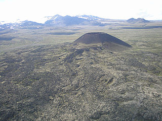
Eve Cone is a well-preserved black cinder cone on the Big Raven Plateau, British Columbia, Canada. It is one of the 30 cinder cones on the flanks of the massive shield volcano of Mount Edziza that formed in the year 700, making it one of the most recent eruptions on the Big Raven Plateau and in Canada. Eve Cone stands by itself in the middle of the Desolation Lava Field and its distinctive shape can be seen from a long distance. Commonly photographed, Eve Cone is covered by light yellow pumice from a close by but unknown vent.
Volcanic Creek Cone is a small cinder cone 20 kilometres northeast of Atlin in northwestern British Columbia. There are two cinder cones and a lava flow at least 3 kilometres long which is present below parts of the tree covered area. The subdued form of Volcanic Creek cone is visible directly below the largest snow patch. The cone has probably suffered through at least one glacial episode. Volcanic Creek cone is part of the Northern Cordilleran Volcanic Province.
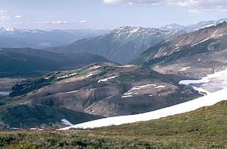
Cinder Cone is a cinder cone with a small crater on the west side of the Helm Glacier in Garibaldi Provincial Park in British Columbia, Canada. Cinder Cone is surrounded by cinder flats and its crater is filled with melt water during the summer. Cinder Cone is eroded easily by melt water during the spring, washing the pyroclastics into the Valley of Desolation. Cinder Cone produced a 9 km (6 mi) long lava flow during the early Holocene.
Sidas Cone is one of the cinder cones located north on the Mount Edziza plateau in British Columbia, Canada. Sidas Cone is visible from almost anywhere around the plateau.

Mousa Ali is a 2,021 metres (6,631 ft) stratovolcano located on the tri-point of Ethiopia, Eritrea and Djibouti. The volcano is the highest point in Djibouti. The volcano's summit is truncated by a caldera, which contains rhyolitic lava domes and lava flows. The last known eruption occurred before the Holocene era.
Cinder Mountain is a partly eroded cinder cone at the head of Snippaker Creek, British Columbia, Canada. It is one of the Iskut-Unuk River Cones and is the source of a basaltic lava flow that extends 4 km (2 mi) north into Copper King Creek. An isolated pile of subaerial basalt flows and associated pillow lava rest on varved clay and till in King Creek. Cinder Mountain last erupted during the Pleistocene.
Gabrielse Cone is a remarkably fresh, clearly postglacial monogenetic cinder cone, located in the Tuya Volcanic Field in British Columbia, Canada. It is about 400 m (1,312 ft) in diameter and has a central crater about 30 m (98 ft) deep. It is Holocene in age and to its northeast appears to be breached with the remnants of a lava flow. The cone is near the headwaters of Iverson Creek.

S P Crater is a cinder cone volcano in the San Francisco volcanic field, 25 miles (40 km) north of Flagstaff, Arizona. It is surrounded by several other cinder cones which are older and more eroded. It is a striking feature on the local landscape, with a well-defined lava flow that extends for 4.3 miles (7 km) to the north.

Vulcan's Throne is a cinder cone volcano and a prominent landmark on the North Rim of the Grand Canyon in Arizona, United States. Vulcan's Throne, about a mile (1.7 km) west of Toroweap overlook, is part of the Uinkaret volcanic field. The journals of traveler George Corning Fraser record a trip to the summit of Vulcan's Throne in 1914. At the time, the surrounding area was used for sheep grazing, and a small reservoir had been constructed at the base of the volcano. Fraser wrote that
Vulcan's Throne is a pure cinder cone covered with scoriae, cinders, clinkers and peperino lying loose on the surface, with a slope, as near as I could measure, from 28° to 31°. A little sage, many cacti and perhaps some other similar low plants grow on it, but otherwise nothing. Climbing it was like ascending a sand-dune. Every step forward involved slipping half way back and boots were soon filled with painful bits of stone.
Kana Cone is a red nested cinder cone in northern British Columbia, Canada, located northeast of Eve Cone in Mount Edziza Provincial Park.
Triplex Cone is a cinder cone in northern British Columbia, Canada. It is thought to have last erupted in the Holocene period.

The Ulysses Fossae are a group of troughs in the Tharsis quadrangle of Mars at 10.06° north latitude and 123.07° west longitude. They were named after an albedo feature name. The area contains pitted cones called Ulysses Colles which were interpreted to be possible Martian equivalents to terrestrial cinder cones.
Keda Cone, sometimes mistakenly spelled Kena Cone, is a cinder cone in northwestern British Columbia, Canada, located in the Snowshoe Lava Field of Mount Edziza Provincial Park. It last erupted during the Holocene epoch.
Snippaker Creek Cone is a cinder cone of the Iskut-Unuk River Cones group in northwestern British Columbia, Canada, located near the western flank of Cinder Mountain. It last erupted during the Holocene epoch.
The Smithsonian Institution's Global Volcanism Program (GVP) documents Earth's volcanoes and their eruptive history over the past 10,000 years. The GVP reports on current eruptions from around the world as well as maintaining a database repository on active volcanoes and their eruptions. In this way, a global context for the planet's active volcanism is presented. Smithsonian reporting on current volcanic activity dates back to 1968, with the Center for Short-Lived Phenomena (CSLP). The GVP is housed in the Department of Mineral Sciences, part of the National Museum of Natural History, on the National Mall in Washington, D.C.

The Smithsonian Institution, founded on August 10, 1846 "for the increase and diffusion of knowledge," is a group of museums and research centers administered by the Government of the United States. The institution is named after its founding donor, British scientist James Smithson. Originally organized as the "United States National Museum," that name ceased to exist as an administrative entity in 1967.


