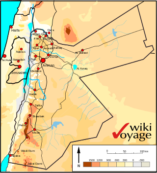
Jordan is situated geographically in Southwest Asia, south of Syria, west of Iraq, northwest of Saudi Arabia, east of Israel. The area is also referred to as the Middle or Near East. The territory of Jordan now covers about 91,880 square kilometres (35,480 sq mi).
Churu is a city in the desert region of Rajasthan state of India. It is known as the gateway to the Thar Desert of Rajasthan. It is the administrative headquarter of Churu District. It lies in the Thar Desert on the National Highway 52 connecting Sangrur to Ankola and is a junction station on the railway line to Bikaner. It is near the shifting sand dunes of the Thar Desert and has grand havelis with marvelous fresco paintings, namely Kanhaiya Lal Bagla Ki Haweli and Surana Haweli, with hundreds of small windows. It also has some fine Chhatris. Near the town is a religious seat of the Nath sect of Sadhus where there are life-size marble statues of their deities and a place for prayers. At the center of the town is a fort built about 500 years ago.

Nagaur is a city and municipal council in Nagaur district of the state of Rajasthan in India. It is the administrative headquarters of Nagaur District. The Nagaur city lies about midway between Jodhpur and Bikaner.
Thathawata is a village located in Churu District of Rajasthan state in India. At the 2001 census, the village had a total population of 2500.

Shekhawati is a semi-arid historical region located in the northeast part of Rajasthan, India. The region was ruled by Shekhawat Rajputs. Shekhawati is located in North Rajasthan, comprising the districts of Jhunjhunu, parts of Sikar that lies to the west of the Aravalis and Churu. It is bounded on the northwest by the Jangladesh region, on the northeast by Haryana, on the east by Mewat, on the southeast by Dhundhar, on the south by Ajmer, and on the southwest by the Marwar region. Its area is 13784 square kilometers.
Fatehpur is a city in the Sikar district of Indian state Rajasthan. It is part of the Shekhawati region. It is midway between Sikar city and Bikaner on National Highway 52. It is also the land to Havelis built by Marwari Seth's. It also has many Kuldevi Temples of the Agarwal community for Bajoria,Bindal, Saraf, Chamadia, Choudhary, Goenka, Singhania, Saraogi, Bhartia Families. It is famous for its extreme weather conditions throughout the year. In winters, the minimum temperature falls below 0° Celsius at night for many days making it the coldest town in India in non mountainous region. In summer the temperature rises to 50° Celsius in the afternoon making it one of the hottest places in India. 1985 Bollywood film Ghulami starting Dharmendra, Naseeruddin Shah, Mithun Chakraborty and Smita Patil was extensively shot here in many of its havelis and the railway station.

Sitapur district is one of the districts which is situated in Uttar Pradesh state of India, with Sitapur town as the district headquarters. Sitapur district is a part of Lucknow division.

Jhang District is a district of Faisalabad division in the Punjab province, Pakistan. Jhang city is the capital of district.
Sikar district is a district of the Indian state Rajasthan in northern India. The city Sikar is the administrative headquarters of the district. Sikar, Laxmangarh, Sri Madhopur, Neem Ka Thana, and Fatehpur Shekahwati are the largest cities and tehsils of the district.
Fadanpura is a village in Fatehpur tehsil of Sikar district in Rajasthan, 5 km away from Fatehpur City by road. There are about 450 houses in the village, with a total population above 1100 people. Five temples in this village and most oldest temple of "THAKUR Ji" made by Shekhawat's situated in middle of this village. Other temples name are Sati Dadi Jamvay Maa Jasnath ji Maharaj and Lord Hanuman. Sati Dadi's temple, made by Khetaram Jangid, is 2km away from this village. Jasnath ji Mharaj's temple made by Jyani is the first temple you can see when you come in this village by road.
Bhuma is a Jat community village in Laxmangarh tehsil in Sikar district in Rajasthan. Bhuma has two habitations : Bhuma Bada and Bhuma Chhota. At the 2001 census the population of the village was 5,743, of which 1,420 are SC people. Bhuma Bara is located 10.9 km dwest of Town Lachhmangarh( also written as Laxmangarh). Bhuma Bara is 30.2 km far from Sikar and 130 km far from Jaipur.
Palsana is a Town located in the Sikar District region of Rajasthan state in India. It is 84 km away from Jaipur, 350 km from Jodhpur 245 km from Bikaner and 250 km from Delhi.
Noor Mang, is a small village situated between Namli Maira and Phalkot in Abbottabad District in the Khyber Pakhtunkhwa province of Pakistan. Noor Mang is located on Murree road in Namli Maira Union Council.

The Culture of Uttar Pradesh is an Indian culture which has its roots in Hindi, Bhojpuri and Urdu literature, music, fine arts, drama and cinema. Lucknow, the capital of Uttar Pradesh, has historical monuments including Bara Imambara and Chhota Imambara, and has preserved the damaged complex of the Oudh-period British Resident's quarters, which are being restored.

Mandela is a town in the Shekhawati region and Jhunjhunu district of Rajasthan state in India.
Nabipura is a village in India located in the Fatehpur tehsil of the Sikar district of the state Rajasthan. It is located 18 km east of Fatehpur. Nearby villages include: Beswa, Balodi, Dhakali, Maroth Pura, Deenwa Ladh Kani, Malta and Bagroda.
Birodi Bari or Birodi Badi or Bidodi Badi or Beerodi Bari is a village in the Laxmangarh administrative region of Sikar district of Indian state Rajasthan. It lies 20 kilometres (12 mi) east of Laxmangarh and 3.5 kilometres (2.2 mi) west of Nawalgarh. It borders Khinwasar, Bidsar, Bidasar, Birodi Chhoti, Jhadhewa, Jogiyon ka bas, Ramsingh Pura and Bhoodha Ka Bas villages.
Chhai Pokhar is a village in the district of Agra in the Indian state of Uttar Pradesh. It is nearby Achhnera or Achnera, connected by road on three sides of the village and by rail. Khera Sandhan is the nearest railway station at about 1 km from the village on Agra- Achnera-Mathura section of NW Railway. It is also known as Three Towers' Village.
Medipally Nakkartha is a village located in Yacharam Mandal, Rangareddy district, Telangana, India, with a population of approximately 5,000 people.
Dildarnagar is a municipality in Kamsaar of Ghazipur District, Uttar Pradesh, India. Dildarnagar is a fast-developing town. It is located 34 km from Ghazipur. It is also known as the heart of the Kamsaar-o-bar region. The total area of Dildarnagar includes Fatehpur Bazar, Dildarnagar Gao, and Nirahukapura. These four neighbourhoods form the town of Dildarnagar. As of the 2011 census, the population of Dildarnagar was 28,913 and the town had an area of 1,995.95 hectares. Dildarnagar is on the road from Varanasi to Buxar. It was also the capital of Dildarnagar Estate.