Cachardistrict is an administrative district in the state of Assam in India. After independence, the pre-existing undivided Cachar district was split into four districts: Dima Hasao, Hailakandi, Karimganj, and the current Cachar district. Silchar is Cachar district's center of government.

Dima Hasao district, is an administrative district in the state of Assam, India. As of 2011, it is the least populous district of Assam.

Haflong is a town and headquarters of Dima Hasao district in the state of Assam in India. It is the only hill station in Assam.
Jatinga, a village on a ridge, is located in Dima Hasao district, Assam, India. It is 330 kilometres (210 mi) south of Guwahati The village is inhabited by about 2,500 Khasi-Pnar people and a few Assamese. It is well-known for being the location of mysterious bird deaths.

The Dimasa people or Dimasa Kachari people are an ethnolinguistic community presently inhabiting in Assam and Nagaland states in Northeastern India. They speak Dimasa, a Tibeto-Burman language. This community is fairly homogeneous and exclusive, with members required to draw from both parents' separate clans. Dimasa kingdom, one of many early states in Assam following the downfall of Kamarupa kingdom, was established by these people. The Dimasas were till recently agricultural, centering on shifting agriculture; but in recent times this has changed with profound changes in the community. Following political problems in the 18th century, the Dimasa ruler moved further south in the plains of Cachar and there took place a division among them–with the hills Dimasa maintaining their traditional living and political exclusiveness, the plains Dimasas have made no attempt to assert themselves.
The Dimasa language is a Tibeto-Burman language spoken by the Dimasa people of the Northeastern Indian states of Assam and Nagaland. The Dimasa language is known to Dimasas as "Grao-Dima" and it is similar to Boro, Kokborok and Garo languages.

Umrangso is an industrial town and a town area committee in Dima Hasao district in the state of Assam, India. It is located at the border of Assam and Meghalaya states some 112 km from Haflong, the district headquarters of Dima Hasao district of Assam.
Mahur is a town and a town area committee in Dima Hasao district in the Indian state of Assam.

Assam is the main and oldest state in the North-East Region of India and as the gateway to the rest of the Seven Sister States. The land of red river and blue hills, Assam comprises three main geographical areas: the Brahmaputra Valley which stretching along the length of the Brahmaputra river, the Barak Valley extending like a tail, and the intervening Karbi Plateau and North Cachar Hills. Assam shares its border with Meghalaya, Arunachal Pradesh, Nagaland, Manipur, Tripura, Mizoram and West Bengal; and there are National Highways leading to their capital cities. It also shares international borders with Bhutan and Bangladesh and is very close to Myanmar. In ancient times Assam was known as Pragjyotisha or Pragjyotishpura, and Kamarupa.
Dima Halam Daogah was an Indian extremist group operating mainly in Assam and Nagaland. The group laid down their arms in January 2013, and claimed to represent the Dimasa and their goal to create a Dimaland or Dimaraji in the two states.
The Zeliangrong people are one of the major indigenous Naga communities living in the tri-junction of Assam, Manipur and Nagaland in India. They are the descendants of Nguiba. The term "Zeliangrong" refers to the Zeme, Liangmai and Rongmei Kindred tribes combined. Earlier, the term also covered the Inpui tribe. The descendants of Hoi of Makuilongdi (Makhel) were divided and were made peripheral appendages to three political entities - Nagaland, Manipur and the Dima Hasao of Assam. The Zeliangrong may be classified as an ethno-cultural entity. The Zeliangrong belong to the larger Southern Mongoloid population and their language belongs to the Sino-Tibetan family of languages.
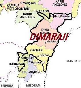
Some Dimasa-Cachar people of northeast India have been demanding a separate state called Dimaraji or "Dimaland" for several decades. It would comprise the Dimasa-inhabited areas, namely Dima Hasao district, parts of Cachar district, parts of Nagaon district, Hojai district and Karbi Anglong district in Assam together with part of Dimapur district in Nagaland.

Kopili River is an interstate river in Northeast India that flows through the states of Meghalaya and Assam and is the largest south bank tributary of the Brahmaputra in Assam.

Busu Dima is an annual cultural festival celebrated by the Dimasa Kachari tribe of India. It is the biggest harvesting festival. It is celebrated after the completion of grain harvest in different villages. The festival is usually organized in January.
Retzawl is a village in Dima Hasao District of Assam State, India. Haflong, the district headquarters as well as its nearest town, is 17 kilometers away to the east, and Harangajao lies to the west.

The West Karbi Anglong district is an administrative unit in the Indian state of Assam. It is a relatively new district formed out of the existing Karbi Anglong district in 2016. The administrative headquarters of the district is located at Hamren. The district is a part of the Karbi Anglong Autonomous Council and is administered according to the provisions of the Sixth Schedule of the Indian Constitution.

Central Assam is an administrative division of Assam under the jurisdiction of a Division Commissioner, who is officially stationed at Nagaon. It consists of the following districts: Dima Hasao, Karbi Anglong, West Karbi Anglong, Hojai, Nagaon and Marigaon.

The North Cachar Hills Autonomous Council (NCHAC), also known as known as the Dima Hasao Autonomous Council, is an autonomous district council in the state of Assam in India. It was constituted under the provisions of the Sixth Schedule of the Constitution of India to administer the Dima Hasao district and to develop the hill people in the area. Its headquarters is in Haflong, Dima Hasao district.
Manderdisa railway station is an Indian railway station of the Lumding–Sabroom section in the Northeast Frontier Railway zone of Indian Railways. The station is situated at Manderdisa in Dima Hasao district in the Indian state of Assam. It serves Manderdisa and surroundings areas. Distance between Lumding Junction and Manderdisa is 10 km (144 mi).

Panimur is a scenic destination in the Dima Hasao district of Assam, India. It is most famous for the Panimur Waterfall, also known as Niagara of Northeast, which forms from the Kopili River as it flows over rocky terrain, creating a wide, cascading waterfall that is a major attraction for tourists and photographers.

