
Scotland Yard is the headquarters of the Metropolitan Police, the territorial police force responsible for policing Greater London's 32 boroughs. Its name derives from the location of the original Metropolitan Police headquarters at 4 Whitehall Place, which had its main public entrance on the Westminster street called Great Scotland Yard. The Scotland Yard entrance became the public entrance, and over time "Scotland Yard" came to be used not only as the common name of the headquarters building, but also as a metonym for the Metropolitan Police Service (MPS) itself and police officers, especially detectives, who serve in it. The New York Times wrote in 1964 that, just as Wall Street gave its name to New York's financial district, Scotland Yard became the name for police activity in London.

Soho is an area of the City of Westminster in the West End of London. Originally a fashionable district for the aristocracy, it has been one of the main entertainment districts in the capital since the 19th century.

The West End of London is a district of Central London, London, England, west of the City of London and north of the River Thames, in which many of the city's major tourist attractions, shops, businesses, government buildings and entertainment venues, including West End theatres, are concentrated.

St Giles Circus is a road junction in the St Giles district of the West End of London at the eastern end of Oxford Street, where it connects with New Oxford Street, Charing Cross Road and Tottenham Court Road, which it is more often referred to owing to the location of Tottenham Court Road Underground station directly under the junction. It is near to Soho, Covent Garden, Bloomsbury and Fitzrovia.
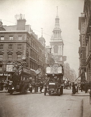
Cheapside is a street in the City of London, the historic and modern financial centre of London, England, which forms part of the A40 London to Fishguard road. It links St Martin's Le Grand with Poultry. Near its eastern end at Bank junction, where it becomes Poultry, is Mansion House, the Bank of England, and Bank station. To the west is St Paul's Cathedral, St Paul's tube station and square.

Old Compton Street is a road that runs east–west through Soho in the West End of London, named after Henry Compton who raised funds for St Anne's Church in 1686. The area, particularly this street, became home to French Protestant refugees in 1681. Known for its diverse and artistic traditions, the street housed businesses, artists, philosophers, and was frequented by communists and proto-beatniks. The Algerian Coffee Stores, one of the oldest shops on the street, was established in 1887. Post World War II, the street became a center for modern and trad jazz. Since the 1970s, Old Compton Street has been a focal point for London's gay community, with numerous gay bars, restaurants, and specialty shops. The Admiral Duncan pub, a notable gay venue, was bombed in 1999 in a hate crime attack. The street is also home to the Prince Edward Theatre.

Soho Square is a garden square in Soho, London, hosting since 1954 a de facto public park let by the Soho Square Garden Committee to Westminster City Council. It was originally called King Square after Charles II, and a much weathered statue of the monarch has stood in the square, with an extended interruption, since 1661, one year after the restoration of the monarchy.
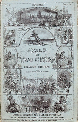
A Tale of Two Cities is a historical novel published in 1859 by English author Charles Dickens, set in London and Paris before and during the French Revolution. The novel tells the story of the French Doctor Manette, his 18-year-long imprisonment in the Bastille in Paris, and his release to live in London with his daughter Lucie whom he had never met. The story is set against the conditions that led up to the French Revolution and the Reign of Terror.

Dean Street is a street in Soho, central London, running from Oxford Street south to Shaftesbury Avenue. It crosses Old Compton Street and is linked to Frith Street by Bateman Street.
Greek Street is a street in Soho, London, leading south from Soho Square to Shaftesbury Avenue. The street is famous for its restaurants and cosmopolitan nature.

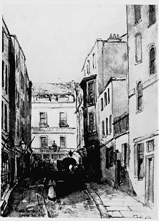
Bar Hercules, historically the Pillars of Hercules, was a pub in Greek Street, Soho, London, originally named for the Pillars of Hercules of antiquity. Most of what exists was built around 1910, but the pub dates back to 1733. The road at the side of the pub through the arch is named Manette Street, after Dr Manette, one of the characters from A Tale of Two Cities, who is described in the book as living near Soho Square.
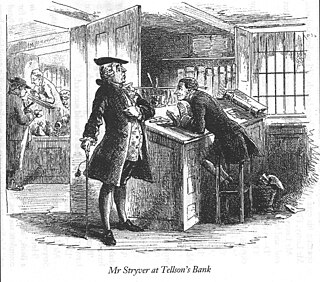
C.J. Stryver is a character in Charles Dickens's 1859 novel A Tale of Two Cities and in the television and film adaptations of the story. He is a barrister in London, with the character Sydney Carton working under him.

The House of St Barnabas, at 1 Greek Street, Soho, is a Grade I Listed Georgian building in London notable for its rococo plasterwork interiors and for other architectural features.
Carlisle House was the name of two late seventeenth-century mansions in Soho, London, on opposite sides of Soho Square. One, at the end of Carlisle Street, is sometimes incorrectly said to have been designed by Christopher Wren; it was destroyed in the Blitz. The other was the location of Madame Cornelys' entertainments in the eighteenth century and was demolished in 1791; part of the site was cleared in 1891 for the building of St. Patrick's church.

The Lamb and Flag is a Grade II listed public house at Rose Street, Covent Garden, London, WC2.

The Foyles Building at 111–119 Charing Cross Road and 1–12 Manette Street, London, was the flagship store of the Foyles bookshop chain from 1929 to 2014, and at one time, the world's largest bookshop. The business moved next door to 107–109 Charing Cross Road in 2014, in a redevelopment of the old Saint Martin's School of Art building. The building was demolished in 2017.

The arm and hammer is a symbol consisting of a muscular arm holding a hammer. Used in ancient times as a symbol of the god Vulcan, it came to be known as a symbol of industry, for example blacksmithing and gold-beating. It has been used as a symbol by many different kinds of organizations, including banks, local government, and socialist political parties.

The Intrepid Fox was a pub at 97–99 Wardour Street, Soho, London, established in 1784 by the publican Samuel House, who named it after the prominent British Whig statesman Charles James Fox. The pub was located on the corner of Wardour Street and Peter Street.
The Rose Street Club was a far-left, anarchist organisation based in what is now Manette Street, London. Originally centred around London's German community, and acting as a meeting point for new immigrants, it became one of the leading radical clubs of Victorian London in the late-nineteenth century. Although its roots went back to the 1840s, it was properly formed in 1877 by members of a German émigré workers' education group, which soon became frequented by London radicals, and within a few years had led to the formation of similar clubs, sometimes in support and sometimes in rivalry. The Rose Street Club provided a platform for the radical speakers and agitators of the day and produced its own paper, Freiheit—which was distributed over Europe, and especially Germany—and pamphlets for other groups and individuals. Although radical, the club initially focused as much on providing a social service to its members as on activism. With the arrival of the anarchist Johann Most in London in the early 1880s, and his increasing influence within the club, it became increasingly aligned with anarchism.

Kensington New Town is an area of housing in Kensington, London, which was developed in the early 19th century. It lies to the south of Kensington High Street and to the southwest of Kensington Gardens.

