Albert Bridge is a heritage-listed railway bridge of steel truss design crossing the Brisbane River between Indooroopilly and Chelmer in the City of Brisbane, Queensland, Australia. It was designed by Henry Charles Stanley and built from 1894 to 1895 by John McCormick & Son as a replacement for an earlier bridge lost to flooding in 1893. Both bridges were named in honour of the Prince of Wales, Prince Albert. It was added to the Queensland Heritage Register on 21 October 1992.

Fritz Todt was a German construction engineer and senior Nazi who rose from the position of Inspector General for German Roadways, in which he directed the construction of the German autobahns (Reichsautobahnen), to become the Reich Minister for Armaments and Ammunition. From that position, he directed the entire German wartime military economy.

Eugène Freyssinet was a French structural and civil engineer. He was the major pioneer of prestressed concrete.
A cantilever bridge is a bridge built using structures that project horizontally into space, supported on only one end. For small footbridges, the cantilevers may be simple beams; however, large cantilever bridges designed to handle road or rail traffic use trusses built from structural steel, or box girders built from prestressed concrete.
The Autobahn is the federal controlled-access highway system in Germany. The official German term is Bundesautobahn, which translates as 'federal motorway'. The literal meaning of the word Bundesautobahn is 'Federal Auto(mobile) Track'.

Bangabandhu Bridge, also known as the Jamuna Multi-purpose Bridge is a bridge opened in Bangladesh in June 1998. It connects Bhuapur on the Jamuna River's east bank to Sirajganj on its west bank. It was the 11th longest bridge in the world when constructed in 1998 and at present is the 6th longest bridge in South Asia. The Jamuna River, which it spans, is one of the three major rivers of Bangladesh, and is fifth largest in the world in discharge volume.
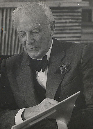
Paul Bonatz was a German architect, member of the Stuttgart School and professor at the technical university in that city during part of World War II, and from 1954 until his death. He worked in many styles, but most often in a simplified neo-Romanesque, and designed important public buildings both in the Weimar Republic and under the Third Reich, including major bridges for the new autobahns. In 1943 he designed several buildings in Turkey, returning to Stuttgart in 1954.

German Bestelmeyer was a German architect, university lecturer, and proponent of Nazi architecture. Most of his work was in South Germany.
Josef Thorak was an Austrian-German sculptor. He became known for oversize monumental sculptures, particularly of male figures, and was one of the most prominent sculptors of the Third Reich.

Bundesautobahn 5 is a 445 km (277 mi) long Autobahn in Germany. Its northern end is the Hattenbach triangle intersection (with the A 7. The southern end is at the Swiss border near Basel. It runs through the German states of Hessen and Baden-Württemberg and connects on its southern ending to the Swiss A 2.

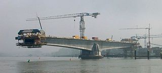
An extradosed bridge employs a structure that combines the main elements of both a prestressed box girder bridge and a cable-stayed bridge. The name comes from the word extrados, the exterior or upper curve of an arch, and refers to how the "stay cables" on an extradosed bridge are not considered as such in the design, but are instead treated as external prestressing tendons deviating upward from the deck. In this concept, they remain part of the main bridge superstructure.

Bundesautobahn 9 is an autobahn in Germany, connecting Berlin and Munich via Leipzig and Nuremberg. It is the fifth longest autobahn spanning 529 km (328.71 mi).

The Hawkesbury River railway bridge is a heritage-listed railway bridge in New South Wales, Australia that carries the Main North railway line across the Hawkesbury River. It is located just north of the town of Brooklyn on the northern outskirts of Sydney. The railway bridge was to be the last link in a railway network that linked the state capitals Adelaide, Melbourne, Sydney and Brisbane and was a major engineering feat at the time. The original railway bridge was built in 1889 and replaced by the current bridge in 1946. The 1946 bridge was added to the New South Wales State Heritage Register on 2 April 1999.
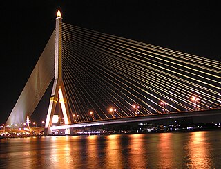
The Rama VIII Bridge is a cable-stayed bridge crossing the Chao Phraya River in Bangkok, Thailand. It was built to alleviate traffic congestion on the nearby Phra Pinklao Bridge. Construction of the bridge took place from 1999 to 2002. The bridge was opened on 7 May 2002 and inaugurated on 20 September, the birth anniversary of the late King Ananda Mahidol, after whom it is named. The bridge has an asymmetrical design, with a single pylon in an inverted Y shape on the west bank of the river. Its eighty-four cables are arranged in pairs on the side of the main span and in a single row on the other. The bridge has a main span of 300 metres (980 ft), and was one of the world's largest asymmetrical cable-stayed bridges at the time of its completion.

Berlinka is the informal Polish and Russian name given to sections of the unfinished Reichsautobahn Berlin-Königsberg, which was a pre-World War II German Reichsautobahn project to connect Berlin with Königsberg in East Prussia. In the late 1930s, the sections near these two cities were finished, but not the larger section in between. The German demand in 1939 to run this road across the Polish Corridor with extraterritorial status and Poland's refusal to allow this was an important element in the tensions that led to the start of World War II. After the war, the German Democratic Republic, the People's Republic of Poland and the Soviet Union's Kaliningrad Oblast inherited the remnants.

Langkawi Sky Bridge is a 125-metre (410 ft) curved pedestrian cable-stayed bridge in Malaysia, completed in 2005. The bridge deck is 660 metres (2,170 ft) above sea level at the peak of Gunung Mat Cincang on Pulau Langkawi, the main island of the Langkawi archipelago in Kedah. The Langkawi Sky Bridge can be reached by first taking the Langkawi Cable Car to the Top Station, where an inclined lift called SkyGlide takes visitors from the Top Station down to the bridge.
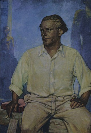
Erna Lendvai-Dircksen was a German photographer known for a series of volumes of portraits of rural individuals from throughout Germany. During the Third Reich, she also photographed for eugenicist publications and was commissioned to document the new Autobahn and the workers constructing it.
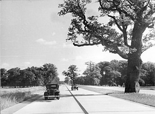
The Reichsautobahn system was the beginning of the German autobahns under Nazi Germany. There had been previous plans for controlled-access highways in Germany under the Weimar Republic, and two had been constructed, but work had yet to start on long-distance highways. After previously opposing plans for a highway network, the Nazis embraced them after coming to power and presented the project as Hitler's own idea. They were termed "Adolf Hitler's roads" and presented as a major contribution to the reduction of unemployment. Other reasons for the project included enabling Germans to explore and appreciate their country, and there was a strong aesthetic element to the execution of the project under the Third Reich; military applications, although to a lesser extent than has often been thought; a permanent monument to the Third Reich, often compared to the pyramids; and general promotion of motoring as a modernization that in itself had military applications.

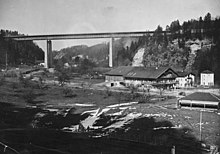
The Drackensteiner Hang is a mountainside in the Swabian Alps at Kirchheim unter Teck in Baden-Württemberg, Germany. Bundesautobahn 8 between Stuttgart and Ulm divides into separate northbound and southbound routes on either side of the peak. The two halves of the autobahn each traverse one tunnel and a series of two or three viaducts that were designed by Paul Bonatz and built for the Reichsautobahn; the bridges were all destroyed in World War II and had to be rebuilt, and the route in one direction was only completed in the 1950s. A project to reroute the autobahn with new tunnels and bridges has been postponed indefinitely.

The George Chaffey Bridge is a road bridge in Australia that carries the Sturt Highway across the Murray River from Buronga to Mildura.