Related Research Articles

The Appalachian Mountains, often called the Appalachians, are a mountain range in eastern to northeastern North America. Here, the term "Appalachian" refers to several different regions associated with the mountain range, and its surrounding terrain. The general definition used is one followed by the United States Geological Survey and the Geological Survey of Canada to describe the respective countries' physiographic regions. The U.S. uses the term Appalachian Highlands and Canada uses the term Appalachian Uplands; the Appalachian Mountains are not synonymous with the Appalachian Plateau, which is one of the provinces of the Appalachian Highlands.

The geology of the Appalachians dates back more than 1.2 billion years to the Mesoproterozoic era when two continental cratons collided to form the supercontinent Rodinia, 500 million years prior to the development of the range during the formation of Pangea. The rocks exposed in today's Appalachian Mountains reveal elongate belts of folded and thrust faulted marine sedimentary rocks, volcanic rocks, and slivers of ancient ocean floor—strong evidences that these rocks were deformed during plate collision. The birth of the Appalachian ranges marks the first of several mountain building plate collisions that culminated in the construction of Pangea with the Appalachians and neighboring Anti-Atlas mountains near the center. These mountain ranges likely once reached elevations similar to those of the Alps and the Rocky Mountains before they were eroded.

The richly textured landscape of the United States is a product of the dueling forces of plate tectonics, weathering and erosion. Over the 4.5 billion-year history of the Earth, tectonic upheavals and colliding plates have raised great mountain ranges while the forces of erosion and weathering worked to tear them down. Even after many millions of years, records of Earth's great upheavals remain imprinted as textural variations and surface patterns that define distinctive landscapes or provinces.

The Watchung Mountains are a group of three long low ridges of volcanic origin, between 400 and 500 feet high, lying parallel to each other in northern New Jersey in the United States. The name is derived from the American Native Lenape name for them, Wach Unks. In the 18th century, the Euro-American settlers also called them the Blue Mountains or Blue Hills. The Watchung Mountains are known for their numerous scenic vistas overlooking the skylines of New York City and Newark, New Jersey, as well as their isolated ecosystems containing rare plants, endangered wildlife, rich minerals, and globally imperiled trap rock glade communities. The ridges traditionally contained the westward spread of urbanization, forming a significant geologic barrier beyond the piedmont west of the Hudson River; the town of Newark, for example, once included lands from the Hudson to the base of the mountains. Later treaties moved the boundary to the top of the mountain, to include the springs.
The Palisades, also called the New Jersey Palisades or the Hudson River Palisades, are a line of steep cliffs along the west side of the lower Hudson River in Northeastern New Jersey and Southeastern New York in the United States. The cliffs stretch north from Jersey City about 20 miles (32 km) to near Nyack, New York, and are visible at Haverstraw, New York. They rise nearly vertically from near the edge of the river, and are about 300 feet (90 m) high at Weehawken, increasing gradually to 540 feet (160 m) high near their northern terminus. North of Fort Lee, the Palisades are part of Palisades Interstate Park and are a National Natural Landmark.

The Taconic orogeny was a mountain building period that ended 440 million years ago (Ma) and affected most of modern-day New England. A great mountain chain formed from eastern Canada down through what is now the Piedmont of the east coast of the United States. As the mountain chain eroded in the Silurian and Devonian periods, sediment spread throughout the present-day Appalachians and midcontinental North America.

The geography of New York City is characterized by its coastal position at the meeting of the Hudson River and the Atlantic Ocean in a naturally sheltered harbor. The city's geography, with its scarce availability of land, is a contributing factor in making New York the most densely populated major city in the United States. Environmental issues are chiefly concerned with managing this density, which also explains why New York is among the most energy-efficient and least automobile-dependent cities in the United States. The city's climate is temperate.
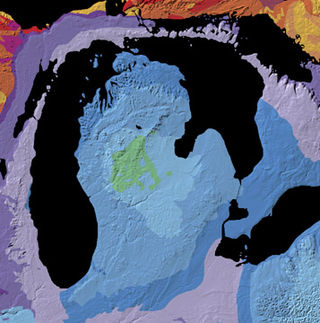
The Michigan Basin is a geologic basin centered on the Lower Peninsula of the U.S. state of Michigan. The feature is represented by a nearly circular pattern of geologic sedimentary strata in the area with a nearly uniform structural dip toward the center of the peninsula.

Sourland Mountain is a 17 miles (27 km) long ridge in central New Jersey, U.S., extending from the Delaware River at Lambertville to the western end of Hillsborough Township near the community of Neshanic, through Montgomery Township and into Hopewell Township in Mercer County. It comprises the largest contiguous forest in Central Jersey, nearly 90 square miles (233 km2) in area. The highest point is only 568 feet (173 m) above sea level, but the way it rises steeply from the surrounding farmland has earned it the title of 'mountain'. The ridge itself sits within a larger area of rough terrain called The Sourlands.

Cushetunk Mountain is a ring shaped mountain in the U.S. state of New Jersey, located in Readington and Clinton Township in Hunterdon County. The Lenape Native Americans called the mountain "Cushetunk" meaning "place of hogs" after the wild hogs found there. In the 1960s, the valley at the heart of the mountain was dammed and filled with water to create Round Valley Reservoir. Today, the mountain and its accompanying lake act as a vital water supply to Central New Jersey, while at the same time providing numerous recreational opportunities to the region.

Campgaw Mountain is the northernmost ridge of the volcanically formed Watchung Mountains, along the border of Franklin Lakes, Oakland, and Mahwah in Bergen County, New Jersey, United States. Located almost entirely within the bounds of Campgaw Mountain Reservation, the mountain offers numerous outdoor recreational opportunities, including the only ski slope in the Watchungs. Campgaw Mountain is commonly considered to be part of the greater Ramapo Mountains region, but the flora and geology of the mountain is quite different from the surrounding area and more closely resembles the nearby Preakness Range to the south.

The Geology of Pennsylvania consists of six distinct physiographic provinces, three of which are subdivided into different sections. Each province has its own economic advantages and geologic hazards and plays an important role in shaping everyday life in the state. From the southeast corner to the northwest corner of the state, the include: the Atlantic Plain Province province, the Piedmont Province, the New England Province, the Ridge and Valley Province, the Appalachain Province, and the Central Lowlands Province.
New Jersey is a very geologically and geographically diverse region in the United States' Middle Atlantic region, offering variety from the Appalachian Mountains and the Highlands in the state's northwest, to the Atlantic Coastal Plain region that encompasses both the Pine Barrens and the Jersey Shore. The state's geological features have impacted the course of settlement, development, commerce and industry over the past four centuries.
The Reading Prong is a physiographic subprovince of the New England Uplands section of the New England province of the Appalachian Highlands. The prong consists of mountains made up of crystalline metamorphic rock.

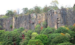
Goffle Hill, also referred to as Goffle Mountain and historically known as Totoway Mountain and Wagaraw Mountain, is a range of the trap rock Watchung Mountains on the western edge of the Newark Basin in northern New Jersey. The hill straddles part of the border of Bergen County and Passaic County, underlying a mostly suburban setting. While hosting patches of woodlands, perched wetlands, and traprock glades, the hill is largely unprotected from development. Extensive quarrying for trap rock has obliterated large tracts of the hill in North Haledon, and Prospect Park. Conservation efforts seeking to preserve undeveloped land, such as the local Save the Woods initiative (2007–present), are ongoing.

The Ramapo Fault zone is a system of faults between the northern Appalachian Mountains and Piedmont areas to the east. Spanning more than 185 miles (298 km) in New York, New Jersey, and Pennsylvania, it is perhaps the best known fault zone in the Mid-Atlantic region, and some small earthquakes have been known to occur in its vicinity. Recently, public knowledge about the fault has increased, especially after the 1970s, when the fault's proximity to the Indian Point nuclear plant in New York was noted.
The Watchung Outliers include six areas of isolated low hills and rock outcrops of volcanic and sedimentary origin in the U.S. states of New York, New Jersey, and Pennsylvania. These geologic outliers are primarily diminutive and detached remnants of the Triassic/Jurassic age Watchung Mountain basalt flows with intervening layers of sedimentary rock. All six of the outliers are found along the western edge of the Newark Basin, occupying small synclines adjacent to the Ramapo fault system. The outliers, from north to south, are known as: Ladentown, Union Hill, New Germantown/Oldwick, Prospect Hill, Sand Brook, and Jacksonwald.
The Trenton Prong is a physiographic subprovince of the Piedmont Uplands section of the Piedmont province of the Appalachian Mountains. The prong consists of crystalline metamorphic rock.
The topography of the New England Uplands section is that of a maturely-dissected plateau with narrow valleys, and the entire area is greatly modified by glaciation. It is the most widespread of the geomorphic sections in the New England Province, extending from Canada through New England down to the Seaboard section and extending southwestward through New York and New Jersey as two narrow upland projections, the Reading Prong and the Manhattan Prong. Numerous hills and mountains rise above the general level of the upland; except in the presence of mountains, the horizon of the regional landscape is fairly level. Glaciation has resulted in the erosion and rounding off of the bedrock topography and numerous rock basin lakes. Glacial drift is thin, patchy, and stony, and ice-contact features such as kames, kame terraces, and eskers are abundant. The surface of the New England Uplands slopes southeast from maximum inland altitudes around 670 meters, excluding the other mountainous sections of the province, to about 122 to 152 meters along its seaward edge at the narrow coastal Seaboard section, which goes down to sea level.

The geology of the State of New York is made up of ancient Precambrian crystalline basement rock, forming the Adirondack Mountains and the bedrock of much of the state. These rocks experienced numerous deformations during mountain building events and much of the region was flooded by shallow seas depositing thick sequences of sedimentary rock during the Paleozoic. Fewer rocks have deposited since the Mesozoic as several kilometers of rock have eroded into the continental shelf and Atlantic coastal plain, although volcanic and sedimentary rocks in the Newark Basin are a prominent fossil-bearing feature near New York City from the Mesozoic rifting of the supercontinent Pangea.
References
- ↑ Sarah Bradford Landau; Carl W. Condit (1996). Rise of the New York Skyscraper, 1865–1913. Yale University Press. p. 24.
![]() This article incorporates public domain material from The Highlands Province. United States Geological Survey.
This article incorporates public domain material from The Highlands Province. United States Geological Survey.