
Leyte is an island in the Visayas group of islands in the Philippines. It is eighth-largest and sixth-most populous island in the Philippines, with a total population of 2,626,970 as of 2020 census.

Leyte Gulf is a gulf in the Eastern Visayan region in the Philippines. The bay is part of the Philippine Sea of the Pacific Ocean, and is bounded by two islands; Samar in the north and Leyte in the west. On the south of the bay is Mindanao Island, separated from Leyte by the Surigao Strait. Dinagat Island partly encloses the gulf to the southeast, and the small Homonhon Island and Suluan Island, sit astride the eastern entrance to the Gulf. It is approximately 130 km (81 mi) north-south, and 60 km (37 mi) east-west.

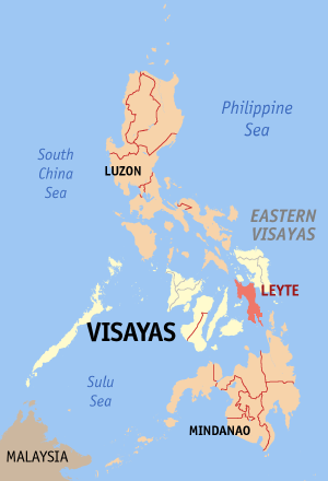
Leyte, officially the Province of Leyte, is a province in the Philippines located in the Eastern Visayas region, occupying the northern three-quarters of Leyte Island. Its capital is the city of Tacloban, administered independently from the province. Leyte is situated west of Samar Island, north of Southern Leyte and south of Biliran. To the west across the Camotes Sea is the province of Cebu.

Samar, officially the Province of Samar, formerly named Western Samar, is a province in the Philippines located in the Eastern Visayas region. Its capital is the city of Catbalogan. It is bordered by Northern Samar, Eastern Samar, Leyte and the Leyte Gulf, and includes several islands in the Samar Sea. Samar is connected to the island of Leyte via the San Juanico Bridge.

Tacloban, officially the City of Tacloban, is a 1st class highly urbanized city in the Eastern Visayas region of the Philippines. The city is autonomous from the province of Leyte, although it serves as its provincial capital. According to the 2020 census, Tacloban has a population of 251,881, making it the most populous city in the Eastern Visayas. The city is located 360 miles (580 km) southeast from Manila.

Guiuan, officially the Municipality of Guiuan, is a 2nd class municipality in the province of Eastern Samar, Philippines. It constitutes the southeastern extremity of Samar Island and some adjacent islands, surrounded by major bodies of water including Leyte Gulf and the Philippine Sea. According to the 2020 census, it has a population of 53,361 people, making it the most populous municipality in Eastern Samar and the second most populous administrative division in the entire province after the capital city Borongan.

Suluan is an island barangay in the Philippines, in the municipality of Guiuan, Eastern Samar. It lies east of Leyte Gulf and west of Emden Deep. The inhabitants of the island were the first Filipinos to trade and interact with Ferdinand Magellan's expedition which anchored on the nearby island of Homonhon on March 16, 1521.

USS Artisan (ABSD-1), later redesignated as (AFDB-1), was a ten-section, non-self-propelled, large auxiliary floating drydock of the United States Navy. The only U.S. warship with this name, Artisan was constructed in sections during 1942 and 1943 by the Everett-Pacific Shipbuilding & Dry Dock Company, in Everett, Washington; the Chicago Bridge & Iron Company, in Eureka, California; the Pollock-Stockton Shipbuilding Company, in Stockton, California; and the Chicago Bridge & Iron Company, in Morgan City, Louisiana. This ship was commissioned at Everett, Washington, on 10 May 1943, Captain Andrew R. Mack in command. With all ten sections joined, she was 927 feet long, 28 feet tall, and with an inside clear width of 133 feet 7 inches.

USS Scrimmage (AM-297) was an Admirable-class minesweeper built for the United States Navy during World War II. She was built to clear minefields in offshore waters. She served in the Pacific Ocean and, because of her valiant efforts in combat, her crew returned home with six battle stars.
USS Portunus (AGP-4) was an LST-1-class tank landing ship acquired by the U.S. Navy for use during World War II as a motor torpedo boat (MTB) tender. She was named after a Roman god of the sea, who had jurisdiction over ports and the shores.

Rodne Galicha y Rodiño is a Filipino environmentalist and human rights activist currently involved in climate justice, biodiversity conservation and natural resources conflict management. He is the author of a pocket-sized book on emerging environment issues: We Are Nature. On 5 December 2013, he received the 2013 Hero for the Environment national individual award from the Center for Environmental Concerns in collaboration with the Department of Environment and Natural Resources of the Republic of the Philippines. He was Philippine Manager for The Climate Reality Project and currently doing his voluntary work for ecological and cultural organization called Bayay Sibuyanon in his home-island of Sibuyan. In 2018, the Philippine Tatler included him in the Generation T list as one of the 50 brightest connectors, creative visionaries, influential innovators and disruptive talents in the Philippines. He is also one of the recipients of the 2018 The Outstanding Young Men (TOYM) of the Philippines. Stepping-up climate and environmental action, he heads Living Laudato Si movement in the Philippines; and national convener of Aksyon Klima Pilipinas. He co-founded OeconoMedia, a faith-based news platform that produces and distributes original reporting about the environment, the climate crisis, and the global Laudato si' campaign of the Catholic Church.

Typhoon Haiyan, known in the Philippines as Super Typhoon Yolanda, was one of the most powerful tropical cyclones ever recorded. On making landfall, Haiyan devastated portions of Southeast Asia, particularly the Philippines. It is one of the deadliest Philippine typhoons on record, killing at least 6,300 people in that country alone. In terms of JTWC-estimated 1-minute sustained winds, Haiyan is tied with Meranti in 2016 for being the second strongest landfalling tropical cyclone on record, only behind Goni of 2020. As of January 2014, bodies were still being found. Haiyan was also the most intense tropical cyclone worldwide in 2013.
Eastern Visayas is an administrative region in the Philippines, designated as Region VIII. It consists of three main islands, Samar, Leyte and Biliran. The region has six provinces, one independent city and one highly urbanized city namely, Biliran, Leyte, Northern Samar, Samar, Eastern Samar, Southern Leyte, Ormoc and Tacloban. The highly urbanized city of Tacloban is the sole regional center. These provinces and cities occupy the easternmost islands of the Visayas group of islands.

Climate change in the Philippines is having serious impacts such as increased frequency and severity of natural disasters, sea level rise, extreme rainfall, resource shortages, and environmental degradation. All of these impacts together have greatly affected the Philippines' agriculture, water, infrastructure, human health, and coastal ecosystems and they are projected to continue having devastating damages to the economy and society of the Philippines.

USS ABSD-5, later redesignated as AFDB-5, was a nine-section, non-self-propelled, large auxiliary floating drydock of the US Navy. Advance Base Sectional Dock-5 was constructed in sections during 1943 and 1944 by the Chicago Bridge & Iron Company in Morgan City, Louisiana for World War II. With all nine sections joined, she was 825 feet long, 28 feet tall, and with an inside clear width of 133 feet 7 inches. ABSD-5 had two traveling 15-ton capacity crane with an 85-foot radius and two or more support barges. The two side walls were folded down under tow to reduce wind resistance and lower the center of gravity. ABSD-5 had 6 capstans for pulling, each rated at 24,000 lbf (110,000 N) at 30 ft/min (0.15 m/s), 4 of the capstans were reversible. There were also 4 ballast compartments in each section.

Typhoon Phanfone, known in the Philippines as Typhoon Ursula, was a strong and deadly tropical cyclone which traversed the Philippines on Christmas Eve and Christmas Day in 2019, the first typhoon to do so since Nock-ten in 2016.
Marinel Sumook Ubaldo (1997) is a Filipinos climate activist from the Philippines who helped to organise the first youth climate strike in her country. She testified as a community witness for the Philippines Commission on Human Rights as part of their investigation into corporate responsibility and whether the effects of climate change can be considered violations of Filipinos’ human rights.
Leyte–Samar Naval Base was a large United States Navy base in the Philippines on the Islands of Leyte, Samar and the San Pedro Bay. The base was built during World War II to support the many naval ships fighting and patrolling in the South West Pacific theatre of war as part of the Pacific War. A number of naval facilities were built on the east coast of Leyte island starting October 20, 1944. The first base was built at between the city of Tacloban and Anibong Point, a mile north of the city. Headquarters for the Seventh Fleet was built at Tolosa, 10 miles south of Tacloban on Leyte. The bases were on the large San Pedro Bay in Leyte Gulf which provided safe anchorage for many ships. Due to the lack of dry ground in Tacloban a second base was built on the east side of Leyte Gulf, on the south tip of Samar, on Calicoan Island and Tubabao Island. At Samar, a large Naval Depot was built to support the Pacific War. Samar was about 50 miles across Leyte Gulf from Tacloban. All construction was done by the Navy's Seabees.
Victory Island is a small island off the coast of Samar, Philippines, situated in the Leyte Gulf. It is locally administered by the barangay with the same name and is controlled by the municipality of Guiuan, Eastern Samar. According to the 2020 census, Victory Island has an estimated population of 598.

US Naval Base Philippines was number of United States Navy bases in the Philippines Islands in the Pacific Ocean. Most were built by the US Navy Seabees, Naval Construction Battalions, during World War II. The US Naval Bases in Philippines were lost to the Empire of Japan in December 1941 during the Philippines campaign of 1941–1942. In February 1945 the United States Armed Forces retook the Philippines in the Battle of Manila in 1945. Before the captured US bases on Luzon were retaken the US Navy Seabees built a new large base, Leyte-Samar Naval Base, on the Philippine Island of Leyte, starting in October 1944.

