
The Canadian Shield, also called the Laurentian Plateau, is a geologic shield, a large area of exposed Precambrian igneous and high-grade metamorphic rocks. It forms the North American Craton, the ancient geologic core of the North American continent. Glaciation has left the area with only a thin layer of soil, through which exposures of igneous bedrock resulting from its long volcanic history are frequently visible. As a deep, common, joined bedrock region in eastern and central Canada, the Shield stretches north from the Great Lakes to the Arctic Ocean, covering over half of Canada and most of Greenland; it also extends south into the northern reaches of the United States.
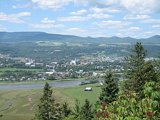
Charlevoix is a cultural and natural region in Quebec, on the north shore of the Saint Lawrence River as well as in the Laurentian Mountains area of the Canadian Shield. This dramatic landscape includes rolling terrain, fjords, headlands, and bays; the region was designated a World Biosphere Reserve by UNESCO in 1989. Administratively, it comprises the Charlevoix and Charlevoix-Est regional county municipalities within the larger Capitale-Nationale administrative region.

Manicouagan Reservoir is an annular lake in central Quebec, Canada, covering an area of 1,942 km2 (750 sq mi). The lake island in its centre is known as René-Levasseur Island, and its highest point is Mount Babel. The structure was created 214 (±1) million years ago, in the Late Triassic, by the impact of a meteorite 5 km (3 mi) in diameter. The lake and island are clearly seen from space and are sometimes called the "eye of Quebec". The lake has a volume of 137.9 km3 (33.1 cu mi).

Rochechouart impact structure or Rochechouart astrobleme is an impact structure in France. Erosion has over the millions of years has mostly destroyed its impact crater, the initial surface expression of the asteroid impact leaving highly deformed bedrock and fragments of the crater's floor as evidence of it.

The Slate Islands are a small archipelago in Lake Superior, Ontario, Canada, about 12 kilometres (7.5 mi) south of the town of Terrace Bay. The island group, consisting of 15 islands in total, was created by a meteorite impact which formed a crater about 32 km (20 mi) wide. In 1985, the Ontario government established the Slate Islands as a natural environment provincial park. The islands are notable for having Ontario's largest herd of boreal woodland caribou.

René-Levasseur Island is a large island in the centre of Lake Manicouagan in Quebec, Canada. Its highest peak is Mount Babel, at 952 m, which is contained in the Louis-Babel Ecological Reserve. With a total area of 2,020 km2, the island is larger in area than the annular lake in which it is situated. René-Levasseur Island is the world's second largest lake island.
The Wuling Mountains are a mountain range located in Central China, running from Chongqing Municipality and East Guizhou to West Hunan. They are home to many ethnic groups, including as the Tujia, Han, Miao, Dong, and Bai.

Northern Alberta is a geographic region located in the Canadian province of Alberta.

The Long Point Biosphere Reserve is located in southern Canada on the shores of Lake Erie in Norfolk County. The area encompasses a rich mosaic of ecological systems associated with erosion deposit sand spit formations around the Laurentian Great Lakes, as well as some of the largest remaining forest tracts in "Carolinian Canada". The variety of habitats supports a rich flora and fauna, including a waterfowl staging area and a migration stopover area for land birds of continental importance. Long Point Biosphere Reserve has been recognized as a Ramsar site and as a globally significant Important Bird Area by Bird Life International. Established in 1960, the bird observatory is the oldest, continuously operated, in North America.

Grands-Jardins National Park is a provincial park, located in the Unorganized Territory of Lac-Pikauba, in the Charlevoix Regional County Municipality, an administrative region of Capitale-Nationale, in Quebec, Canada.
Louis-Babel Ecological Reserve is an ecological reserve on René-Levasseur Island in Quebec, Canada. It is named after Canadian priest Louis Babel. It was established on January 30, 1991.
Biosphere reserves are areas comprising terrestrial, marine and coastal ecosystems. The biosphere reserve title is handed over by UNESCO. Each reserve promotes solutions reconciling the conservation of biodiversity with its sustainable use. Biosphere reserves are 'Science for Sustainability support sites' – special places for testing interdisciplinary approaches to understanding and managing changes and interactions between social and ecological systems, including conflict prevention and management of biodiversity. Biosphere reserves are nominated by national governments and remain under the sovereign jurisdiction of the states where they are located. Their status is internationally recognized.

Riding Mountain Biosphere Reserve (RMBR) is a UNESCO World Biosphere Reserve designated by the United Nations Educational, Scientific and Cultural Organization (UNESCO) in 1986 as part of its Man and the Biosphere Programme. The RMBR, which encompasses Riding Mountain National Park and twelve surrounding municipalities in the province of Manitoba, is one of 16 Biosphere Reserves in Canada. Ecologically sensitive ecosystems include the grasslands, deciduous forest and boreal forest. Although grasslands occupy only 7,400 of the total 1,331,800 hectares, they are considered of national importance since they exist as discrete units and the rare climax rough fescue community represents the eastern extent of its range. The Biosphere Reserve extends the protection of these ecosystems outside of park boundaries. Municipalities in the Riding Mountain Biosphere Reserve include Clanwilliam – Erickson, Dauphin, Gilbert Plains, Grandview, Harrison Park, Lakeshore, McCreary, Rosedale, St. Rose, Riding Mountain West, Rossburn, and Yellowhead. First Nations in the Biosphere Reserve include Rolling River First Nation, Keeseekoowenin First Nation, Waywayseecappo First Nation, and Tootinaowaziibeeng First Nation. Asessippi Provincial Park and Duck Mountain Provincial Forest also border the Biosphere Reserve.
The Komodo Biosphere Reserve and National Park is situated between Flores and Sumbawa in Indonesia. It is renowned for its population of about 5,000 giant lizards, called 'Komodo dragons'. They exist nowhere else in the world and are of significant interest to scientists studying the theory of evolution.
The Dyfi Biosphere is situated at the coast of south-central Wales in the estuary of the River Dyfi, and is a biosphere reserve representative of salt marshes and estuarine systems in the west of the United Kingdom. The estuary forms one of the most important wildfowl and shorebird centres in Wales and also comprises a Ramsar site.
The Hanma Biosphere Reserve is located in Inner Mongolia and encompasses a significant part of the boreal forest (Taiga) found in China. The reserve covers a range of forest and wetland ecosystems rich in biological diversity, including many types of endangered and rare species. Ecological interference by humans is minimal, resulting in abundant natural resources and the high quality of local vegetation and ecology. The cold temperate coniferous forest represents the most well-preserved forest system in China and is of significant scientific value.
Clayoquot Sound Biosphere Reserve is a UNESCO Biosphere Reserve situated in Clayoquot Sound on the west coast of Vancouver Island in British Columbia, Canada. A diverse range of ecosystems exist within the biosphere reserve boundaries, including temperate coastal rainforest, ocean and rocky coastal shores.
UNESCO Biosphere Reserves are environment-protected scientific-research institutions of international status that are created with the intent for conservation in a natural state the most typical natural complexes of biosphere, conducting background ecological monitoring, studying of the surrounding natural environment, its changes under the activity of anthropogenic factors.

The Uapishka Biodiversity Reserve is a protected area in the Côte-Nord region of Quebec. It is one of five biodiversity reserves in the province. It is to the east of the Manicouagan Reservoir and includes a large part of the Monts Groulx. It is also part of the central area of the Manicouagan Uapishka Biosphere Reserve.
The Petit lac Manicouagan is a lake in the Côte-Nord region of Quebec, Canada. It is impounded by the Hart-Jaune Dam at its outlet to the Hart Jaune River.


