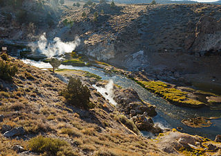
Long Valley Caldera is a depression in eastern California that is adjacent to Mammoth Mountain. The valley is one of the Earth's largest calderas, measuring about 20 mi (32 km) long (east-west), 11 mi (18 km) wide (north-south), and up to 3,000 ft (910 m) deep.

A hot spring, hydrothermal spring, or geothermal spring is a spring produced by the emergence of geothermally heated groundwater onto the surface of the Earth. The groundwater is heated either by shallow bodies of magma or by circulation through faults to hot rock deep in the Earth's crust.

Geothermal energy is thermal energy extracted from the Earth's crust. It combines energy from the formation of the planet and from radioactive decay. Geothermal energy has been exploited as a source of heat and/or electric power for millennia.
Hydrothermal circulation in its most general sense is the circulation of hot water. Hydrothermal circulation occurs most often in the vicinity of sources of heat within the Earth's crust. In general, this occurs near volcanic activity, but can occur in the shallow to mid crust along deeply penetrating fault irregularities or in the deep crust related to the intrusion of granite, or as the result of orogeny or metamorphism. Hydrothermal circulation often results in hydrothermal mineral deposits.

Geysir, sometimes known as The Great Geysir, is a geyser in south-western Iceland, that geological studies suggest started forming about 1150 CE. The English word geyser derives from Geysir. The name Geysir itself is derived from the Icelandic verb geysa. Geysir lies in the Haukadalur valley on the slopes of Laugarfjall lava dome, which is also the home to Strokkur geyser about 50 metres (160 ft) to the south. The Strokkur geyser may be confused with it, and the geothermal field it is in is known usually as either, Geysir or Haukadalur.

Kullu is a district in Himachal Pradesh, India. It borders Shimla district to the south, Mandi and Kangra districts to the west, Kinnaur to the east and the Lahaul and Spiti district to the north and east. The largest valley in this mountainous district is the Kullu Valley. The Kullu valley follows the course of the Beas River, and ranges from an elevation of 833 m above sea level at Aut to 3330 m above sea level at the Atal Tunnel South Portal, below the Rohtang Pass. The town of Kullu, located on the right side of the Beas River, serves as the administrative headquarters of the Kullu district. The Kullu district also incorporates several riverine tributary valleys of the Beas, including those of the Parvati, Sainj, and Tirthan rivers, and thus some regions somewhat distant from the Kullu valley. The economy of the district relies mainly on horticulture, agriculture, tourism, and traditional handicrafts.

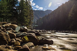
Parvati Valley is a Himalayan valley situated in the northern Indian state of Himachal Pradesh. From the confluence of the Parvati River with the River Beas, the valley runs eastwards, through a steep-sided valley from the town of Bhuntar, in the Kullu district of Himachal Pradesh in Northern India.

Parvati River is a river in the Parvati Valley in Himachal Pradesh, northern India that flows into the Beas River at Bhuntar, some 10 km south of Kullu. It rises from the Man Talai Glacier below the Pin Parbati Pass and flows in a gradual curve from north-northwest to west-southwest past the important temple town of Manikaran.

Kullu is a municipal council town that serves as the administrative headquarters of the Kullu district of the Indian state of Himachal Pradesh. It is located on the banks of the Beas River in the Kullu Valley about 10 kilometres (6.2 mi) north of the airport at Bhuntar, Kullu.

Alvord Hot Springs is a geothermal spring located in Harney County in southeastern Oregon in the United States.
Paonta Sahib is an industrial town of Himachal Pradesh in India. It is located in the south of Sirmaur district, on National Highway 72. Paonta Sahib is an important place of worship for Sikhs, hosting a large Gurdwara named Gurudwara Paonta Sahib, on the banks of the river Yamuna. The river is the boundary between the states of Himachal Pradesh and Uttarakhand.

Vasant Panchami, also rendered Vasanta Panchami and Saraswati Puja in honour of the Hindu goddess Saraswati, is a festival that marks the preparation for the arrival of spring. The festival is celebrated in Indian religions in different ways depending on the region. Vasant Panchami also marks the start of preparation for Holika and Holi, which take place forty days later. The Vasant Utsava (festival) on Panchami is celebrated forty days before spring, because any season's transition period is 40 days, and after that, the season comes into full bloom.

Bhuntar is a town and a nagar panchayat in Kullu district in the state of Himachal Pradesh, India. It is just 11 km from Kullu town, and lies along National Highway 3. The Kullu-Manali Airport is located in Bhuntar. Bhuntar is located on the right bank of the Beas River. Directly opposite Bhuntar, near the left bank of the Beas River, there is the confluence of the Parvati River with the River Beas. The Parvati Valley begins at this confluence and runs eastward, through a steep-sided valley towards Kasol and Manikaran.

Tira Sujanpur, also known as Sujanpur Tira or Sujanpur Tihra, is a town and municipal council in the Hamirpur district of Himachal Pradesh. Founded in the 18th century by the Katoch dynasty, the town is located midst the Himalayan foothills on the southern bank of the Beas River. It was one of the centers of Kangra-style miniature paintings and Hindu temples built in an unusual blend of conventional Nagara architecture shrines with Mughal architecture palace, the latter decorated with floral murals of legends from the Ramayana and the Mahabharata.

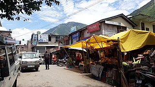
Manikaran is a town located in the Parvati Valley on river Parvati, northeast of Bhuntar in the Kullu District of Himachal Pradesh, India. It is at an altitude of 1760 m and is located 4 km from Kasol, about 45 km from Kullu and about 35 km from Bhuntar. The small town is known for its hot springs and pilgrim centres of Manali and Kullu. An experimental geothermal energy plant has also been set up here.

Manimahesh Lake is a high altitude lake situated close to the Manimahesh Kailash Peak in the Pir Panjal Range of the Himalayas, in the Bharmour subdivision of Chamba district of the Indian state of Himachal Pradesh. The religious significance of this lake is next to that of the Lake Manasarovar in Tibet.

Hot Creek, starting as Mammoth Creek, is a stream in Mono County of eastern California, in the Western United States. It is within the Inyo National Forest.

The Shree Vajreshwari Yogini Devi Mandir is a Hindu temple dedicated to the goddess Vajreshwari, located in the town Vajreshwari, 75 km away from Mumbai. The town, earlier known as Vadvali, was renamed Vajreshwari in honour of the presiding deity of the temple.

Kalyanasundara, also spelt as Kalyansundar and Kalyana Sundara, and known as Kalyanasundara-murti, Vaivahika-murti and Panigrahana-murti ( पाणिंग्रहण-मूर्ति), is the iconographical depiction of the wedding of the Hindu deities Shiva and Parvati. The couple are often depicted performing the panigrahana ritual of a Hindu wedding, where the groom accepts the bride by taking her right hand in his.

Tourism in Himachal Pradesh relates to tourism in the Indian state of Himachal Pradesh. This is popularly renowned for its Himalayan landscapes and popular hill-stations. Many outdoor activities such as rock climbing, mountain biking, paragliding, ice-skating, trekking, rafting, and heli-skiing are popular tourist attractions in Himachal Pradesh.


