
The Krishna River is a river in the Deccan plateau and is the third-longest river in India, after the Ganges and Godavari. It is also the fourth-largest in terms of water inflows and river basin area in India, after the Ganges, Indus and Godavari. The river, also called Krishnaveni, is 1,400 kilometres (870 mi) long and its length in Maharashtra is 282 kilometres. It is a major source of irrigation in the Indian states of Maharashtra, Karnataka, Telangana and Andhra Pradesh.

The Godavari is India's second longest river after the Ganga river and drains into the third largest basin in India, covering about 10% of India's total geographical area. Its source is in Trimbakeshwar, Nashik, Maharashtra. It flows east for 1,465 kilometres (910 mi), draining the states of Maharashtra (48.6%), Telangana (18.8%), Andhra Pradesh (4.5%), Chhattisgarh (10.9%) and Odisha (5.7%). The river ultimately empties into the Bay of Bengal through an extensive network of distributaries. Measuring up to 312,812 km2 (120,777 sq mi), it forms one of the largest river basins in the Indian subcontinent, with only the Ganga and Indus rivers having a larger drainage basin. In terms of length, catchment area and discharge, the Godavari is the largest in peninsular India, and had been dubbed as the Dakshina Ganga.

Mettur is an industrial and tourist town located in the Salem district in the state of Tamil Nadu, India. It is best known for the Mettur Dam which is the largest dam in south India.

Bhavani is an interstate Indian river which flows through Indian states of Kerala and Tamil Nadu, India. It originates from the Western Ghats and is one among the three rivers of Kerala which flows in eastward direction.

Damodar River is a river flowing across the Indian states of Jharkhand and West Bengal. The valley is rich in mineral resources and is home to large-scale mining and industrial activity. It was also known as the Sorrow of Bengal because of its ravaging floods in the plains of West Bengal. The construction of several dams on the Damodar and its tributaries has helped control some of the flooding.
The Cooum river, or simply Koovam, is one of the shortest classified rivers draining into the Bay of Bengal. This river is about 72 km (45 mi) in length, flowing 32 km (20 mi) in the city of Chennai and the rest in rural part. The river is highly polluted in the urban area (Chennai). Along with the Adyar River running parallel to the south and the Kosasthalaiyar River, the river trifurcates the city of Chennai and separates Northern Chennai from Central Chennai. It is also sometimes known as Thiruvallikenni river

Periyar, IPA:[peɾijɐːr], is the longest river and the river with the largest discharge potential in the Indian state of Kerala. It is one of the few perennial rivers in the region and provides drinking water for several major towns. The Periyar is of utmost significance to the economy of Kerala. It generates a significant proportion of Kerala's electrical power via the Idukki Dam and flows along a region of industrial and commercial activity. The river also provides water for irrigation and domestic use throughout its course besides supporting a rich fishery. Due to these reasons, the river has been named the "Lifeline of Kerala". Kochi city, in the vicinity of the river mouth draws its water supply from Aluva, an upstream site sufficiently free of seawater intrusion. Twenty five percent of Kerala's industries are along the banks of river Periyar. These are mostly crowded within a stretch of 5 kilometres (3 mi) in the Eloor-Edayar region (Udhyogamandal), about 10 kilometres (6 mi) north of Kochi harbor.

The Subarnarekha River flows through the Indian states of Jharkhand, West Bengal and Odisha.
Pothundi Dam is an irrigation dam near Pothundi village in the Palakkad district of Kerala state, India. Constructed in the 19th century, it is considered one of the oldest dams in India. It provides irrigation to an area of 5,470 hectares in the Palakkad district and drinking water supply to the Nemmara, Ayalur, Melarcode Panchayat. An unusual feature of the earth dam is the core wall, which is built with a mixture of jaggery and quick lime.

Thalaiyar Falls"prohibited Water falls by Theni forest division", also known as Rat Tail Falls is a waterfall Located in the Theni District,which flows as Manjalar River, one of the tributaries of Vaigai river which flows in the south of Tamil Nadu State, South India. It is 297 m (974 ft) tall and is the highest waterfall in Tamil Nadu, the Sixth highest waterfall in India and the 267th highest in the world.
Vadugapatti is a village in Periyakulam Taluk, Theni district, Madurai Region in the Indian state of Tamil Nadu.

The River Nagavali also known as Langulya is one of the main rivers of Southern Odisha and Andhra States in India, between Rushikulya and Godavari basins.
Gurupura, Karnataka, India is a small town situated on the Phalguni, or Gurupura River. It is located about 345 kilometres west of Bangalore, the state capital, and 13 kilometres east of Mangalore, Karnataka's chief port city.

Panchet Dam was the last of the four multi-purpose dams included in the first phase of the Damodar Valley Corporation (DVC). It was constructed across the Damodar River at Panchet in Dhanbad district in the Indian state of Jharkhand, and opened in 1959.

The Amaravathi Dam is a dam constructed across the Amaravathi River. It is located at Amaravathinagar, 25 kilometres (16 mi) south of Udumalpet on SH 17 in the Indira Gandhi Wildlife Sanctuary, Tirupur district in the Indian state of Tamil Nadu. The associated Amaravathi Reservoir is 9.31 square kilometres (3.59 sq mi) in area and 33.53 metres (110.0 ft) deep. The dam was built primarily for irrigation and flood control and now also has four megawatts of electrical generating capacity installed. It is notable for the significant population of mugger crocodiles living in its reservoir and catchment basin.

The Adyar River, originating near the Chembarambakkam Lake in Kanchipuram district, is one of the three rivers which winds through Chennai (Madras), Tamil Nadu, India, and joins the Bay of Bengal at the Adyar estuary. The 42.5-kilometre (26.4 mi) long river contributes to the estuarine ecosystem of Chennai. Despite the high pollution levels, boating and fishing take place in this river. The river collects surplus water from about 200 tanks and lakes, small streams and the rainwater drains in the city, with a combined catchment area of 860 square kilometres (331 sq mi). Most of the waste from the city is drained into this river and the Cooum.

Tilaiya Dam was the first of the four multi-purpose dams included in the first phase of the Damodar Valley Corporation. It was constructed across the Barakar River, at Tilaiya in Koderma district in the Indian state of Jharkhand and opened in 1953.
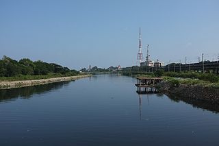
Kosasthalaiyar River, also known as Kortalaiyar, is one of the three rivers that flow in the Chennai metropolitan area.

Manjalar originates from Palani Hills, Tamil Nadu and runs towards east and joins the Vaigai River near Koottathu. There are nine anicuts and nine tanks in this sub-basin. It receives an annual rainfall of 775 millimetres (30.5 in). The total sub-basin area is 470 square kilometres (180 sq mi). The total ayacut of the sub-basin is 2,155.53 hectares.

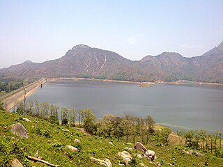
The Pazhassi Dam also called Kulur Barrage is a stone masonry diversion structure in Kannur district, Kerala, India. It is named after king Pazhassi Raja, a patriot who died a heroic death in the war. The dam is constructed across the west flowing Bavali river near Veliyambra. It was commissioned by Prime Minister Morarji Desai in 1979. It mainly functions as an irrigation dam, serving a command area of 11,525 hectares in Iritty taluk of the Kannur District. The water from this dam also meets the drinking water requirement of Kannur district. The dam site and the reservoir are known for their scenery.

