
Guiuan, officially the Municipality of Guiuan, is a 2nd class municipality in the province of Eastern Samar, Philippines. It constitutes the southeastern extremity of Samar Island and some adjacent islands, surrounded by major bodies of water including Leyte Gulf and the Philippine Sea. According to the 2020 census, it has a population of 53,361 people, making it the most populous municipality in Eastern Samar and the second most populous administrative division in the entire province after the capital city Borongan.
Carles, officially the Municipality of Carles, is a 2nd class municipality in the province of Iloilo, Philippines. According to the 2020 census, it has a population of 72,637 people.

Estancia, officially the Municipality of Estancia, is a 2nd class municipality in the province of Iloilo, Philippines. According to the 2020 census, it has a population of 53,200 people.

San Rafael, officially the Municipality of San Rafael, is a 5th class municipality in the province of Iloilo, Philippines. According to the 2020 census, it has a population of 17,795 people.

Igbon Island is an island and barangay in northeastern Iloilo, Philippines. It is part of the municipality of Concepcion. According to the 2010 census, it has a population of 2,547. The island is moderately known in the Philippines for its scuba diving.

Sicogón is an island in northern Iloilo, which is part of the municipality of Carles, Iloilo, Philippines. It is named after cogon, a type of grass found in abundance on the island. According to the 2010 census, it has a population of 5,238.

Pan de Azucar, variously known as Tampisaw Island or Tambaliza, is a populated island in the Visayan Sea in the Philippines. The island is known for MountPan de Azucar a steep volcanic cone and a prominent landmark at the northern entrance of Guimaras Strait.

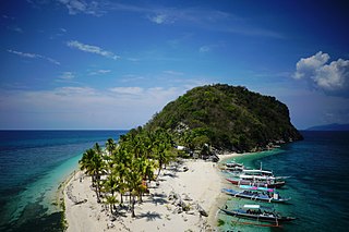
Islas de Gigantes is an island chain within the larger Western Visayas archipelago in the Visayan Sea. It is part of the municipality of Carles, Iloilo, Philippines, and the northernmost part of Iloilo province. The Gigantes islands consist of about ten islands; the two largest are Gigantes Norte and Gigantes Sur. According to the 2010 census, it has a population of 12,224. There is also a lighthouse on Gigantes Norte.
Bayas Island is a small island and barangay in northeastern Iloilo, Philippines. It is part of the municipality of Estancia. According to the 2010 census, it has a population of 2,316. The Island was titled to Filomena Reyes Aclaro and is now shared to the locals.
Loguingot is a small island-barangay in northeastern Iloilo, Philippines. It is part of the municipality of Estancia. According to the 2010 census, it has a population of 796. Fishing is the main source of income for the island's residents.
Botlog Island is an island and barangay in northeastern Iloilo, Philippines. It is part of the municipality of Concepcion. According to the 2010 census, it has a population of 441.
Malangabang is an island and barangay in northeastern Iloilo, Philippines. It is part of the municipality of Concepcion. According to the 2010 census, it has a population of 2,925. Fishing is the main source of income for the island's residents.The Owner is Honorato Ciriaco.
Danao-Danao Island is a small, low-lying island in northeastern Iloilo, Philippines. It is part of the municipality of Concepcion.
Baliguian Island is an inhabited island in northeastern Iloilo, Philippines. It is the westernmost of the Concepcion Islands and politically administered by the municipality of Concepcion. A virtually flat island, Baliguian features a lighthouse to aid in ship navigation.
Magalumbi is an island in northeastern Iloilo, Philippines. It is part of the municipality of Batad, although the official provincial government website lists it as an offshore island of Estancia. Magalumbi is part of barangay Tanao, which has a population of 1,903 according to the 2010 census.
Nabunot is an island in northeastern Iloilo, Philippines. It is one of fourteen islands politically administered by the municipality of Carles.
Himamylan is an uninhabited island in northeastern Iloilo, Philippines. It is one of fourteen islands politically administered by the municipality of Carles.
Calagnaan is an island in northeastern Iloilo, Philippines. It is one of fourteen islands politically administered by the municipality of Carles. The population of the island is 5,017 as of 2020 census.
Binuluangan is an inhabited island-barangay in northeastern Iloilo, Philippines. It is one of fourteen islands politically administered by the municipality of Carles. In 2010 it had a population of 1,682. There is an elementary school on the island.
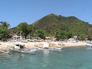
Balbagon is a teardrop-shaped island in northeastern Iloilo, Philippines. It is one of fourteen islands politically administered by the municipality of Carles. There is a small beach resort on the island.
