
Georgian architecture is the name given in most English-speaking countries to the set of architectural styles current between 1714 and 1830. It is named after the first four British monarchs of the House of Hanover—George I, George II, George III, and George IV—who reigned in continuous succession from August 1714 to June 1830. The so-called great Georgian cities of the British Isles were Edinburgh, Bath, pre-independence Dublin, and London, and to a lesser extent York and Bristol. The style was revived in the late 19th century in the United States as Colonial Revival architecture and in the early 20th century in Great Britain as Neo-Georgian architecture; in both it is also called Georgian Revival architecture. In the United States the term "Georgian" is generally used to describe all buildings from the period, regardless of style; in Britain it is generally restricted to buildings that are "architectural in intention", and have stylistic characteristics that are typical of the period, though that covers a wide range.

Oxfordshire is a ceremonial and non-metropolitan county in South East England. It is locally governed by Oxfordshire County Council and the lower-tier authorities of its five non-metropolitan districts: City of Oxford, Cherwell, South Oxfordshire, Vale of White Horse, and West Oxfordshire. The county is landlocked and bordered by Northamptonshire to the north-east, Warwickshire to the north-west, Buckinghamshire to the east, Berkshire to the south, Wiltshire to the south-west, and Gloucestershire to the west. The areas of Oxfordshire south of the River Thames were part of the historic county of Berkshire, including the county's highest point, the 261-metre (856 ft) White Horse Hill. The largest settlement in the county is Oxford, its only city, with an estimated population of 151,584.
Sutton Courtenay is a village and civil parish on the River Thames 2 miles (3 km) south of Abingdon-on-Thames and 3 miles (5 km) northwest of Didcot. Historically part of Berkshire, it has been administered as part of Oxfordshire since the 1974 boundary changes. The 2011 census recorded the parish's population as 2,421. Sutton Courtenay is home to some important structures, such as The Abbey, the Manor House, All Saints' Church, a twelfth-century Norman hall, the Sutton Bridge, and Didcot power station.
Renaud de Courtenay, anglicised to Reginald I de Courtenay, of Sutton, Berkshire, was a French nobleman of the House of Courtenay who took up residence in England and founded the English Courtenay family, who became Earls of Devon in 1335. The title is still held today, by his direct male descendant.

Abingdon Abbey was a Benedictine monastery located in the centre of Abingdon-on-Thames beside the River Thames.

Appleford-on-Thames is a village and civil parish on the south bank of the River Thames about 2 miles (3 km) north of Didcot, Oxfordshire. It was part of Berkshire until the 1974 local government boundary changes. The 2011 Census recorded the parish's population as 350.
Boconnoc is a civil parish in Cornwall, England, United Kingdom, approximately four miles east of the town of Lostwithiel. According to the 2011 census the parish had a population of 96.

Drayton is a village and civil parish about 2 miles (3 km) south of Abingdon, Oxfordshire. It was part of Berkshire until the 1974 boundary changes transferred it to Oxfordshire. The parish includes the hamlet of Sutton Wick. The 2011 Census recorded the parish population as 2,353.

Horton Court is a stone-built 16th century manor house in Horton, near Chipping Sodbury, South Gloucestershire, England. It is a grade I listed building.
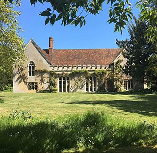
The Abbey in Sutton Courtenay is a medieval courtyard house in the English county of Oxfordshire. It is located in the Vale of White Horse near the River Thames, across the road from the twelfth-century Norman Hall and the Manor House. The Abbey has been recognised as a building of outstanding historic and architectural interest and is considered to be a ‘textbook’ example of an English medieval manor house. It has been a Grade I-listed building since 1952.

East Hendred is a village and civil parish about 4 miles (6.4 km) east of Wantage in the Vale of White Horse and a similar distance west of Didcot. The village is on East Hendred Brook, which flows from the Berkshire Downs to join the River Thames at Sutton Courtenay. Historically in Berkshire, it has been administered as part of Oxfordshire, England, since the 1974 boundary changes. The westernmost parts of the Harwell Science and Innovation Campus are in the parish. The Ridgeway and Icknield Way pass through the parish. It was called "the most well connected village in Britain" because of its connections with the railway station in Didcot and the M4 motorway. Champs Chapel Museum of East Hendred is a small museum in a former 15th century wayside chapel.

Hanbury Manor, centred on the multi-wing Hanbury Manor Hotel, is a converted late-Victorian country house and adjoining golf course in Thundridge, north of Ware, Hertfordshire, some 10 miles (16 km) north of Greater London. It is part of a leisure retreat and country club owned by Marriott Hotels. The house is Grade II* listed on the National Heritage List for England.

Benham Park is a mansion in the English ceremonial county of Berkshire and district of West Berkshire. It is 2 miles (3.2 km) west of Newbury within 500m of a junction of the A34 trunk road Newbury by-pass outside the town side, in the Marsh Benham locality of Speen, a village within and outside the Newbury by-pass. The house is a Grade II* listed building and park is Grade II.

Norah Mary Madeleine Lindsay was a socialite garden designer who between the World wars became a major influence on garden design and planting in the United Kingdom and on the Continent.
West Ginge is a hamlet within the civil parish of Ardington in the English county of Oxfordshire, 3.9 miles (6.3 km) by road to the southeast of Wantage. West Ginge is immediately next to the hamlet of East Ginge, which is contained within the parish of West Hendred. West Ginge is more populous than East Ginge, which is dominated by farm buildings, and the two hamlets are often simply referred to as Ginge.

Marks Hall was a Jacobean country house some 2 miles (3.2 km) north of Coggeshall in Essex, England. Previously a timber manor house, the 17th-century brick building was demolished in 1950.
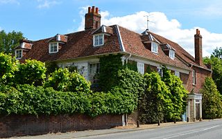
The Wharf, Walton House and Mill House are three houses in Church Street, Sutton Courtenay, Oxfordshire, England. They are part of a complex of buildings bought and expanded by Margot Asquith, wife of the then Prime Minister H. H. Asquith, from 1911 and which formed their country home until his death in 1928. Renovations and expansions were undertaken by the architect Walter Cave and were funded by a number of Margot Asquith's friends and admirers. Margot sold the complex in 1932, and the houses have subsequently been in separate ownership. In 2006, Helena Bonham Carter, Asquith's great-granddaughter bought back Mill House. All three properties are Grade II listed buildings.
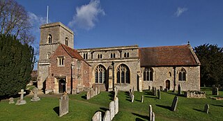
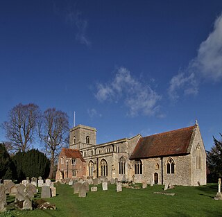
The Church of All Saints, Sutton Courtenay is the Church of England parish church of Sutton Courtenay, England. Extant since at least the 12th century, the church has been Grade I listed since 1966. It is in the centre of the village, near the northeast corner of the village green.
Ockenden International is an English international development non-governmental organisation that helps displaced persons become self-sufficient. They work in Afghanistan, Cambodia, Iran, Lebanon, Pakistan, South Sudan, Sudan and Uganda.
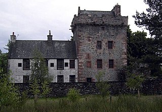
Hills Tower is a sixteenth-century square tower house, with an adjoining eighteenth-century wing, near Dumfries in Scotland. Originally built around 1527 for Edward Maxwell, who had purchased the estate from James Douglas of Drumlanrig, it was improved in the later sixteenth century by his grandson, also Edward Maxwell. In 1721, another Edward Maxwell had a two-storey Georgian wing added to the tower's east side, using stone taken from older buildings nearby, and incorporating armorial panels celebrating members of the Maxwell family.

