
Gadchiroli district is an administrative district in Maharashtra, India. The city of Gadchiroli is the administrative headquarters of the district.
Umaria district is a district of Madhya Pradesh. The town of Umaria is the district headquarters. The district is part of Shahdol Division.

Rajnandgaon is a district of the state of Chhattisgarh in central India. The administrative headquarters the district is Rajnandgaon town.
Ambagarah Chowki is a town in the Chhattisgarh state of India. It is now a district in collaboration with Mohla and Manpur, naming the district Mohla-Manpur-Chowki.

Gurmitkal, or Gurumithakal, is a panchayat town in the northeast of Yadgir district in the Indian state of Karnataka. Administratively, it is under Gurumitkal Taluka.
Kherwara Chhaoni is a census town in the Udaipur district in the Indian state of Rajasthan. It is part of the Vagad region, which includes the districts of Dungarpur, Banswara and parts of Udaipur district. It is in close proximity to two major highways, National Highway 8 and Rajasthan State Highway 76 and National Highway 927A passes through it. Its name derives from the large number of Kher (Khair) trees in the region in the past.

Udumalai, also known as Udumalaipettai and Udumalpet, is a town in Tiruppur district in the Indian state of Tamil Nadu. It is located 535 km south west from the state capital, Chennai and 72 km from Coimbatore. It is the headquarters of Udumalaipettai taluk and had a population of 61,133 as per 2011 Census of India. The town comes under the Udumalaipettai Assembly constituency.
Kabirdham district is one of the 33 administrative districts of Chhattisgarh state in central India. The district was earlier known as Kawardha district. The district is located between 21.32' to 22.28' north latitude and 80.48' to 81.48' east longitude. The district covers an area of 4,447.5 km2 (1,717.2 sq mi). The city of Kawardha is its administrative headquarters. This district is known for the Bhoramdeo temple located at a distance of 18 km from the district headquarters, Kawardha.

Kapsi is a large marketplace village in the Kanker district of Chhattisgarh, India. It holds significance as a model village under two ambitious schemes of the Government of India, namely the Sansad Adarsh Gram Yojana and the Shyama Prasad Mukherjee National Rurban Mission. It is also the headquarters of the Kapsi forest range, the East Kapsi forest subdivision and the Kapsi water resource subdivision. Owing to its sizeable tribal population, it is defined as a Scheduled Area under the Fifth Schedule of the Constitution of India.

Narayanpur district is one of the 33 districts of Chhattisgarh State in Central India. It is one of the two districts created on May 11, 2007. It was carved out from the erstwhile Bastar district. This district occupies an area of 6640 km2 and it had a population of 110,800 in 2001. Narayanpur town is the administrative headquarters of this district. This district comprises 366 villages. It is currently a part of the Red Corridor.
Manpur is a block and the biggest tehsil of Umaria district in Madhya Pradesh. It is situated at a distance of 45 km from its district headquarters Umaria and about 12 km from Bandhavgarh National Park, and The Tala-Jaisinghnagar road passes through it.
Chowki Choura, Akhnoor, is a Sub-Division in Jammu district in Jammu and Kashmir, India.
Adbhar is a historical town and a nagar panchayat in Sakti district in the state of Chhattisgarh in India.
Pakhanjur, also known as Pakhanjore, is a town, nagar panchayat, and the headquarters of the eponymous tehsil in the Kanker District of Chhattisgarh State in India. According to the 2011 Census of India, it is the second largest town in the district by population, only second to the district headquarters Kanker. It is located 120 km (75 mi) south-west of Kanker and 47 km (29 mi) west of the block headquarters Koyalibeda.

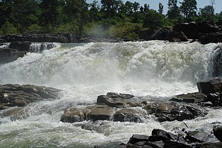
Kherkatta Dam is a medium irrigation project built across the Kotri River, about 10 km (6.2 mi) northwest of Kapsi in the Kanker district of Chhattisgarh, India. It is the largest dam of the district and gets its name from the neighbouring village of Kherkatta. The lake that the dam forms behind it is officially known as the Paralkot Reservoir, which extends in a northwest direction and partially into the Mohla-Manpur-Ambagarh Chowki district. The distance of the dam is approximately 20 km (12 mi) from Pakhanjur, 35 km (22 mi) from Manpur and 110 km (68 mi) from Kanker.
Durgukondal is a village in the Kanker district of Chhattisgarh state, central India. It is the administrative headquarters of its eponymous development block, tehsil and forest range. The 2011 Census of India recorded 1,609 inhabitants in this village.

Mohla-Manpur-Ambagarh Chowki district is one of the four new district in the state of Chhattisgarh, India announced by Bhupesh Baghel on 15 August 2021. It is carved out from existing Rajnandgaon district.
Mohla is a census town in the Indian state of Chhattisgarh. It serves as the district headquarter of the newly created Mohla-Manpur-Ambagarh Chowki district.
Bande, also known as Bande Colony, is a village and the headquarters of the eponymous tehsil in the Kanker District of Chhattisgarh in India. It is also the headquarters of the West Kapsi forest subdivision and two forest ranges, namely East Paralkot and West Paralkot.

