
The Permian Basin is a large sedimentary basin in the southwestern part of the United States. It is the highest producing oil field in the United States, producing an average of 4.2 million barrels of crude oil per day in 2019. This sedimentary basin is located in western Texas and southeastern New Mexico.
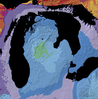
The Michigan Basin is a geologic basin centered on the Lower Peninsula of the U.S. state of Michigan. The feature is represented by a nearly circular pattern of geologic sedimentary strata in the area with a nearly uniform structural dip toward the center of the peninsula.

The San Juan Basin is a geologic structural basin located near the Four Corners region of the Southwestern United States. The basin covers 7,500 square miles and resides in northwestern New Mexico, southwestern Colorado, and parts of Utah and Arizona. Specifically, the basin occupies space in the San Juan, Rio Arriba, Sandoval, and McKinley counties in New Mexico, and La Plata and Archuleta counties in Colorado. The basin extends roughly 100 miles (160 km) N-S and 90 miles (140 km) E-W.

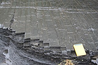
The Ordovician Reedsville Formation is a mapped surficial bedrock unit in Pennsylvania, Maryland, Virginia, West Virginia, and Tennessee, that extends into the subsurface of Ohio. This rock is a slope-former adjacent to the prominent ridge-forming Bald Eagle sandstone unit in the Appalachian Mountains. It is often abbreviated Or on geologic maps.

The Clinton Group is a mapped unit of sedimentary rock found throughout eastern North America. The interval was first defined by the geologist Lardner Vanuxem, who derived the name from the village of Clinton in Oneida County, New York where several well exposed outcrops of these strata can be found. The Clinton Group and its lateral equivalents extend throughout much of the Appalachian Foreland Basin, a major structural and depositional province extending from New York to Alabama. The term has been employed in Kentucky, Maryland, Michigan, New York, Ohio, Pennsylvania, Tennessee, Virginia, and West Virginia, though in many of these areas the same interval is referred to as the Rose Hill, Rockwood, or Red Mountain Formations. Historically the term "Clinton" has also been assigned to several lower Silurian stratigraphic units in Ohio and Kentucky which are now known to be significantly older than the Clinton Group as it was originally defined. Many parts of this succession are richly fossiliferous, making the Clinton Group an important record of marine life during the early Silurian. Several economically valuable rock-types are found within this interval, though it is perhaps best known as a significant source of iron ore

The Bend Arch–Fort Worth Basin Province is a major petroleum producing geological system which is primarily located in North Central Texas and southwestern Oklahoma. It is officially designated by the United States Geological Survey (USGS) as Province 045 and classified as the Barnett-Paleozoic Total Petroleum System (TPS).

The Marcellus Formation or the Marcellus Shale is a Middle Devonian age unit of sedimentary rock found in eastern North America. Named for a distinctive outcrop near the village of Marcellus, New York, in the United States, it extends throughout much of the Appalachian Basin.

The petroleum industry in Ohio dates from 1859. Ohio continues to produce significant quantities of oil and gas, having produced more than 1 billion barrels of oil and 9 trillion cubic feet of natural gas since 1860. Unconventional resources, primarily in eastern Ohio, are likely to increase production in Ohio.
The Utica Shale is a stratigraphical unit of Upper Ordovician age in the Appalachian Basin. It underlies much of the northeastern United States and adjacent parts of Canada.

Tight gas is commonly used to refer to natural gas produced from reservoir rocks with such low permeability that massive hydraulic fracturing is necessary to produce the well at economic rates. The gas is sealed in very impermeable and hard rocks, making their formation "tight". These impermeable reservoirs which produce dry natural gas are also called "Tight Sand".

The Queenston Formation is a geological formation of Upper Ordovician age, which outcrops in Ontario, Canada and New York, United States. A typical outcrop of the formation is exposed at Bronte Creek just south of the Queen Elizabeth Way. The formation is a part of the Queenston Delta clastic wedge, formed as an erosional response to the Taconic Orogeny. Lithologically, the formation is dominated by red and grey shales with thin siltstone, limestone and sandstone interlayers. As materials, comprising the clastic wedge, become coarser in close proximity to the Taconic source rocks, siltstone and sandstone layers are predominant in New York.
The Shadow Lake formation is a geological unit that crops out in Southern Ontario, Canada and northern Pennsylvania, United States. The shaly sections act as a caprock to petroleum reservoirs.

The Jordan Formation is a siliciclastic sedimentary rock unit identified in Illinois, Michigan, Wisconsin, Minnesota, and Iowa. Named for distinctive outcrops in the Minnesota River Valley near the town of Jordan, it extends throughout the Iowa Shelf and eastward over the Wisconsin Arch and Lincoln anticline into the Michigan Basin.
The Black River Group is a geologic group that covers three sedimentary basins in the Eastern and Midwestern United States. These include the Appalachian Basin, Illinois Basin and the Michigan Basin. It dates back to the Late Ordovician period. It is roughly equivalent to the Platteville Group in Illinois. In Kentucky and Tennessee it is also known as the High Bridge Group. In areas where this Geologic Unit thins it is also called the Black River Formation (undifferentiated). One example of this is over the Cincinnati Arch & Findley Arch. Large parts of the Black River have been dolomized (where the parent limestone CaCO3 has been turned into dolomite CaMg(CO3)2.) This happed when there was interaction of hot saline brine and the limestone. This created hydrothermal dolomites that in some areas serve as petroleum reservoirs.

Fracking in Canada was first used in Alberta in 1953 to extract hydrocarbons from the giant Pembina oil field, the biggest conventional oil field in Alberta, which would have produced very little oil without fracturing. Since then, over 170,000 oil and gas wells have been fractured in Western Canada. Fracking is a process that stimulates natural gas or oil in wellbores to flow more easily by subjecting hydrocarbon reservoirs to pressure through the injection of fluids or gas at depth causing the rock to fracture or to widen existing cracks.
The Halibut Field is an oil field, within the Gippsland Basin offshore of the Australian state of Victoria. The oil field is located approximately 64 km offshore of southeastern Australia. The total area of this field is 26.9 km2 and is composed of 10 mappable units.
The geology of Ohio formed beginning more than one billion years ago in the Proterozoic eon of the Precambrian. The igneous and metamorphic crystalline basement rock is poorly understood except through deep boreholes and does not outcrop at the surface. The basement rock is divided between the Grenville Province and Superior Province. When the Grenville Province crust collided with Proto-North America, it launched the Grenville orogeny, a major mountain building event. The Grenville mountains eroded, filling in rift basins and Ohio was flooded and periodically exposed as dry land throughout the Paleozoic. In addition to marine carbonates such as limestone and dolomite, large deposits of shale and sandstone formed as subsequent mountain building events such as the Taconic orogeny and Acadian orogeny led to additional sediment deposition. Ohio transitioned to dryland conditions in the Pennsylvanian, forming large coal swamps and the region has been dryland ever since. Until the Pleistocene glaciations erased these features, the landscape was cut with deep stream valleys, which scoured away hundreds of meters of rock leaving little trace of geologic history in the Mesozoic and Cenozoic.

The geology of Afghanistan includes nearly one billion year old rocks from the Precambrian. The region experienced widespread marine transgressions and deposition during the Paleozoic and Mesozoic, that continued into the Cenozoic with the uplift of the Hindu Kush mountains.
The Coronado Sandstone is a geologic formation that is exposed in eastern Arizona and western New Mexico. It is Cambrian in age based on its position in the stratigraphic column.

The Knox Supergroup, also known as the Knox Group and the Knox Formation, is a widespread geologic group in the Southeastern United States. The age is from the Late Cambrian to the Early Ordovician. Predominantly, it is composed of carbonates, chiefly dolomite, with some limestone. There are also cherty inclusions as well as thin beds of sandstone.


