
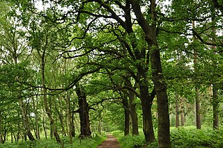
Sherwood Forest is a royal forest in Nottinghamshire, England. Its peculiar fame arises from its historic association with the legend of Robin Hood.
Nottinghamshire is a ceremonial and non-metropolitan county in the East Midlands, England. A landlocked county, it is bordered by South Yorkshire to the north-west, Lincolnshire to the east, Leicestershire to the south, and Derbyshire to the west. The most-populated settlement is the City of Nottingham, which is administered as a unitary authority area. Nottinghamshire County Council, which administers the rest of the county, is based at West Bridgford in Rushcliffe. In 2017, the population was estimated to be 785,800.
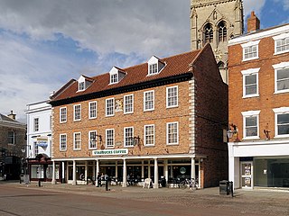
Newark-on-Trent (ˈnjuːəkɒnˈtrɛnt) or Newark is a market town and civil parish in the Newark and Sherwood district in Nottinghamshire, England. It is on the River Trent, and was historically a major inland port. The A1 road bypasses the town on the line of the ancient Great North Road. The town's origins are likely to be Roman, as it lies on a major Roman road, the Fosse Way. It grew up round Newark Castle, St Mary Magdalene church and later developed as a centre for the wool and cloth trades.

Mansfield District is a local government district in Nottinghamshire, England. Its council is based in the town of Mansfield. The district is bounded by the districts of Ashfield, Newark and Sherwood and Gedling, as well as the Derbyshire districts of Bolsover and North East Derbyshire. It is also part of the Mansfield urban area.

Sutton-in-Ashfield is a market town in Nottinghamshire, England, with a population of 48,527 in 2019. It is the largest town in the district of Ashfield, four miles west of Mansfield, two miles from the Derbyshire border and 12 miles north of Nottingham.

The Robin Hood Line is a railway line running from Nottingham to Worksop, Nottinghamshire, in England. The stations between Shirebrook and Whitwell (inclusive) are in the county of Derbyshire.

Mansfield Woodhouse is a settlement about 1.2 miles (2 km) north of Mansfield in Nottinghamshire, England, along the main A60 road in a wide, low valley between the Rivers Maun and Meden. Founded before the Roman Empire, it is noteworthy for its stone-built centre.
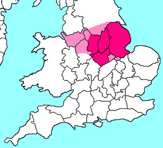
The North Midlands is a loosely defined area covering the northern parts of the Midlands in England. It is not one of the ITL regions like the East Midlands or the West Midlands.

King's Mill Hospital is an acute general district hospital serving the population of north Nottinghamshire and parts of Derbyshire and Lincolnshire. It is managed by the Sherwood Forest Hospitals NHS Foundation Trust. The majority of the hospital buildings are inside Ashfield District Council area with some peripheral buildings falling under Mansfield District Council planning controls.

Southwell is a minster and market town in the district of Newark and Sherwood in Nottinghamshire, England. It is home to the grade-I listed Southwell Minster, the cathedral of the Anglican Diocese of Southwell and Nottingham. The population of the town was recorded at 7,558 in the 2021 Census. The town is on the River Greet and is located geographically 9 miles (14 km) west of Newark on Trent, 15 miles (24 km) north-east of Nottingham, 13 miles (21 km) south-east of Mansfield and 22 miles (35 km) south-east of Worksop.

Clipstone in north Nottinghamshire is a small ex-coal mining village built on the site of an old army base and close to the site of a medieval royal palace. The population of the civil parish was 3,469 at the 2001 census, increasing to 4,665 at the 2011 census.
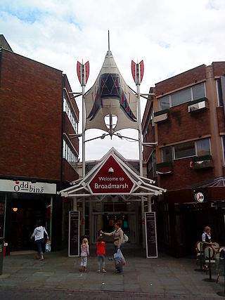
Broadmarsh is a historic area of Nottingham, England. The area was subjected to large scale slum clearance, creating large spaces used for regeneration. A shopping centre, car park, bus station and road complex created in the early 1970s cut-through the traditional thoroughfares from the city centre to the rail and canalside area. A large courts building was opened in 1981.
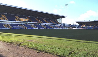
Field Mill, currently known as One Call Stadium for sponsorship reasons, is a football ground in Mansfield, Nottinghamshire, England, and the home of Mansfield Town Football Club.

Mansfield railway station is a railway station which serves the town of Mansfield in Nottinghamshire, England. Alternatively it is named Mansfield Town, to distinguish itself from the GCR's former Mansfield Central and Mansfield Woodhouse's station. The station is 17 miles (27 km) north of Nottingham on the Robin Hood Line, and is managed by East Midlands Railway. The station building is Grade II listed.

Vision West Nottinghamshire College is the trading name of West Nottinghamshire College, a further education college having two main campuses in Mansfield, with smaller sites at nearby Sutton in Ashfield and Kirkby in Ashfield, Nottinghamshire, England.
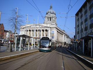
Nottingham is the seventh largest conurbation in the United Kingdom. Despite this, the city had a poor transport system in the 1980s. The government has in the early twenty-first century invested heavily in the transport network of Nottingham, which has led to the re-opening of the Robin Hood Line and the construction of a light rail network, Nottingham Express Transit.

Retford bus station serves the town of Retford, Nottinghamshire, England. It is managed by Nottinghamshire County Council.

Mansfield is a market town and the administrative centre of the Mansfield District in Nottinghamshire, England. It is the largest town in the wider Mansfield Urban Area and the second largest settlement in Nottinghamshire. It gained the Royal Charter of a market town in 1227. The town lies in the Maun Valley, 12 miles (19 km) north of Nottingham. It had a population of 110,500 at the 2021 census, according to the Office for National Statistics. Mansfield is the one local authority in Nottinghamshire with a publicly elected mayor.
Sandhill Lake is a small lake and park, west of the centre of Worksop, Nottinghamshire, England. It is passed by the Chesterfield Canal and the National Cycle Route 6. The lake is 7.6 hectares in area and the path around it has a circumference of 1.21 miles (1.95 km). The River Ryton passes just to the southwest of the canal. The lake, formerly known as Godfrey's Pond, is popular with local anglers, and the area is also used for other leisure activities.
